Argeş River
The Argeș River is a 203-mile (327-km) river located in southern Romania. It originates in the Făgăraș Range of the Southern Carpathians, specifically on the…
What is Argeş River?
The Argeș River is a 203-mile (327-km) river located in southern Romania. It originates in the Făgăraș Range of the Southern Carpathians, specifically on the southern slopes of the Moldoveanu and Negoiu peaks.1
The river flows southward through Curtea de Argeș and Pitești before turning southeast across the Danube Plain to join the Danube near Oltenița. Its basin covers approximately 4,850 square miles (12,550 square km), and its primary tributary is the Dâmbovița.1
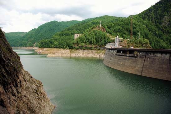
The Argeș is a significant source of hydroelectric power for Romania. A dam located at Căpățâneni creates Lake Vidraru, which serves as a reservoir for the Gheorghe Gheorghiu-Dej hydroelectric station. Development of the river’s hydroelectric potential has been a major focus of the country’s infrastructure efforts since the 1940s.12
How does the Danube River shape Romania’s geography?
The Danube River is a fundamental element of Romania’s physical and economic geography, serving as both a natural boundary and a vital resource.
Boundary and Drainage
The Danube forms the southern frontier of Romania from Moldova Nouă to Călărași. It acts as the primary drainage artery for the country; nearly all Romanian rivers are its tributaries, and they contribute approximately two-fifths of the total Danubian discharge into the Black Sea.3
Topographic Influence
- The Iron Gate: At the Iron Gate gorge, the river cuts through the Southern Carpathians, facilitating transport and providing significant hydroelectric power through a joint project with Serbia.32
- Plains and Floodplains: The river flows along the Romanian Plain, where its floodplain has been historically diked and drained to expand agricultural land. This region supports major river ports such as Drobeta–Turnu Severin, Giurgiu, Brăila, and Galați.2
- The Delta: Near Tulcea, the river forms the Danube delta, a unique, UNESCO-protected ecosystem covering about 2,000 square miles. This region is a major center for fishing and biodiversity.42
What are the main features of the Carpathian Mountains?
The Carpathian Mountains form a vast, arc-shaped mountain system in Central and Eastern Europe, characterized by diverse geological structures and distinct regional divisions.
Major Divisions
The system is generally divided into three primary sections:
- Western Carpathians: Known for clearly marked zoning, these include the Central Western Carpathians, home to the Tatras—the highest massif in the range—which features high-mountain glacial relief, cirque lakes, and waterfalls.6
- Eastern Carpathians: These run in a northwest-southeast direction and are characterized by a compact, banded structure. They include both crystalline and volcanic rock formations, with the Rodna Massif reaching the highest elevations in this section.67
- Southern Carpathians: Also known as the Transylvanian Alps, these mountains consist mainly of hard crystalline and metamorphic rocks. They contain the highest peaks in the entire system, including Moldoveanu and Negoiu in the Făgăraș Mountains.67
Geological and Physical Features
- Geology: The range is a complex system of parallel structural ranges formed by ancient crystalline cores and younger Mesozoic sedimentary rocks. A distinct inner arc of volcanic mountains runs through the eastern section.4
- Karst and Erosion: The mountains feature significant karst landscapes, including extensive cave systems like the Domica-Aggtelek Cave, and deep, scenic gorges carved by rivers.67
- Climate: The region experiences a continental climate, with temperature inversions common in intermontane depressions during winter.8
- Biodiversity: The mountains support distinct altitudinal vegetation zones, ranging from oak and elm forests in the foreland to spruce and subalpine dwarf pine. The region remains a vital habitat for large mammals, including bears, wolves, and lynx.9
How do hydroelectric dams impact local ecosystems?
Hydroelectric dams significantly alter local ecosystems by transforming river environments to serve human needs for power and water management. While they provide renewable energy, their construction and operation often result in profound environmental consequences.1011
Impacts on Aquatic Life
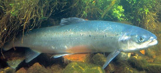
Dams act as physical barriers that impede the movement of migratory fish, such as salmon, preventing them from reaching their spawning grounds. While fish passes—such as ladders and locks—are often installed to mitigate these effects, they have not always been successful in preventing population declines or potential extinction in some river systems.101112
Habitat Alteration and Sedimentation
- Inundation: The creation of large reservoirs leads to the permanent submergence of vast landscapes, destroying terrestrial habitats and displacing both flora and fauna.1011
- Sediment Trapping: Dams disrupt the natural flow of sediment, trapping it within reservoirs. This reduces the sediment supply downstream, which can lead to erosion of the stream channel below the dam.1314
- Water Quality: Reservoirs can become sites for the decomposition of submerged vegetation, which may produce methane, a potent greenhouse gas.11
Human and Cultural Impact
Large-scale dam projects frequently require the displacement of human communities, sometimes involving the relocation of hundreds of thousands of people and the loss of cultural heritage sites.1014
Sources
- Argeş River — Encyclopædia Britannica
- Romania - Drainage of Romania — Encyclopædia Britannica
- Danube River - Physiography — Encyclopædia Britannica
- Romania - Relief — Encyclopædia Britannica
- Romania - Land of Romania — Encyclopædia Britannica
- Carpathian Mountains - Physiography of the Carpathian Mountains — Encyclopædia Britannica
- Carpathian Mountains - Geology — Encyclopædia Britannica
- Carpathian Mountains - Climate — Encyclopædia Britannica
- Carpathian Mountains - Plant and animal life — Encyclopædia Britannica
- dam - Rise of environmental and economic concerns — Encyclopædia Britannica
- dam - Fish passes — Encyclopædia Britannica
- river - Environments of deposition — Encyclopædia Britannica
- reservoir — Encyclopædia Britannica
- Alternative energy - Hydroelectric — Encyclopædia Britannica
- hydroelectric power — Encyclopædia Britannica
- Did you know? — Merriam-Webster
Published on · 4 min read