Aran Islands
The Aran Islands are a group of three limestone islands—Inishmore, Inishmaan, and Inisheer—situated across the mouth of Galway Bay off the west coast of…
What is Aran Islands?
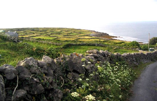
The Aran Islands are a group of three limestone islands—Inishmore, Inishmaan, and Inisheer—situated across the mouth of Galway Bay off the west coast of Ireland1. Administratively part of County Galway, these islands cover approximately 18 square miles (47 square km) and are characterized by their bleak, rocky terrain and sheer cliffs facing the Atlantic Ocean1.1
Because the islands consist of horizontal sheets of Carboniferous limestone lacking natural topsoil, inhabitants historically created soil using seaweed, sand, and manure to farm crops like oats and potatoes. The local population, which maintains the Irish language, also engages in subsistence fishing and cattle raising. Today, tourism is a vital economic contributor, drawing visitors to the islands’ austere landscapes and significant prehistoric and early Christian hill forts. The islands have also served as a cultural touchstone, inspiring works by figures such as John Millington Synge and filmmaker Robert Flaherty.2
What is a currach and how was it used?
A currach (also spelled curragh) is a traditional type of boat, typically described as a large coracle, that has been used for centuries along the west coast of Ireland.4
Historically, these vessels were constructed with a light wooden frame covered in animal hides or, in more modern times, tarred canvas. Their lightweight design and shallow draft made them exceptionally well-suited for the rugged, rocky coastline and unpredictable waters of the Atlantic, allowing them to be easily carried by a single person. They were primarily used by local communities for fishing and for transporting goods and livestock between the islands and the mainland.
How do islanders create soil on limestone?
The Aran Islands are composed of horizontal sheets of Carboniferous limestone and lack naturally occurring topsoil. To overcome this, the islanders historically created their own soil to support the cultivation of crops such as oats and potatoes.
This process involved layering a mixture of seaweed, sand, and manure directly onto the rocky surface. By combining these organic materials and minerals, the inhabitants were able to develop a viable growing medium, allowing them to farm under otherwise difficult environmental conditions.5
What are the famous prehistoric hill forts found there?
The Aran Islands are home to several notable prehistoric stone forts, the most famous of which is Dún Aonghasa. Located on the edge of a 100-meter-high cliff on Inishmore, this massive dry-stone fortification is renowned for its dramatic setting and complex defensive structure, which includes a chevaux-de-frise—a defensive field of upright jagged stones designed to impede attackers.
Other significant prehistoric sites on the islands include:
- Dún Dúchathair (The Black Fort): Situated on a cliff edge, this fort features impressive dry-stone walls and is considered one of the oldest on the island.
- Dún Eochla: Located at the highest point of Inishmore, this circular fort consists of two concentric stone walls and offers panoramic views of the surrounding landscape.
- Dún Eoghanachta: A large, circular stone fort known for its well-preserved walls and internal stone huts.
These structures are significant examples of prehistoric engineering, demonstrating the sophisticated use of local limestone to create defensive strongholds.
Sources
- Aran Islands — Encyclopædia Britannica
- Aran Islands — Merriam-Webster
- list of islands - Ireland — Encyclopædia Britannica
- curragh — Merriam-Webster
- Ireland - Soils — Encyclopædia Britannica
- Cook Islands - Soils — Encyclopædia Britannica
- coral island — Encyclopædia Britannica
Published on · 2 min read