Argun River
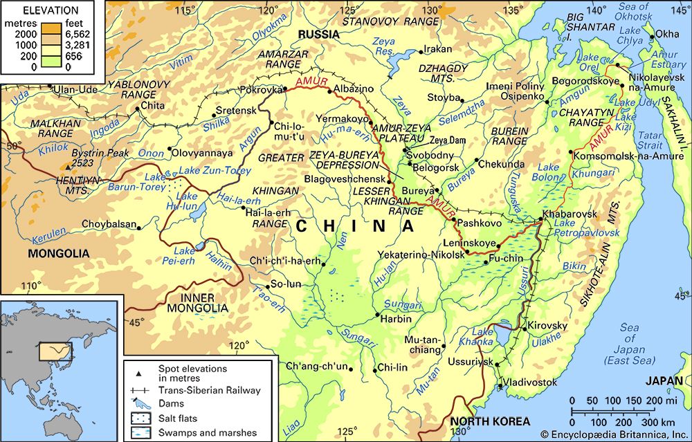
The Argun River is a 1,007-mile (1,620-km) waterway that originates in the Inner Mongolia Autonomous Region of China on the western slope of the Greater…
What is Argun River?
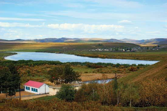
The Argun River is a 1,007-mile (1,620-km) waterway that originates in the Inner Mongolia Autonomous Region of China on the western slope of the Greater Khingan Range. In its upper reaches, it is known as the Hailar River.1
Approximately 600 miles (965 km) of the river’s course serves as the international boundary between China and Russia. Near the village of Luoguhe, the Argun joins the Shilka River to form the Amur River.1
The river flows primarily through a wide valley and maintains a drainage basin of about 63,000 square miles (163,000 square km). During periods of heavy rainfall, the river may overflow into the basin of Hulun Lake. Due to its nature, navigation on the Argun is considered irregular.1
What is the significance of the Amur River?
The Amur River is a vital waterway in East Asia, serving as a significant geographical, economic, and historical landmark. As the longest river in the Russian Far East and one of China’s longest, it forms a major portion of the international border between China and Russia.2
Historical and Geopolitical Significance
The river basin has long been a site of cultural and political interaction. Historically, it was home to various nomadic groups, including the Manchu, whose rise to power led to the establishment of the Qing dynasty. The region became a focal point of territorial disputes between Russia and China, notably following the 17th-century Treaty of Nerchinsk and later 19th-century border adjustments. In the 20th century, the river was a theater for Sino-Soviet tensions, though recent decades have seen increased cooperation regarding navigation and resource development.345
Economic Importance
The Amur is essential to the regional economy:
- Navigation: It serves as a major transport artery, connecting inland ports to the Pacific Ocean.35
- Resources: Fishing remains a primary activity, and the basin holds significant hydroelectric potential, with major dams like those on the Zeya and Bureya rivers supporting regional energy needs.54
- Agriculture: The fertile lowlands, such as the Zeya-Bureya Plain, are critical for crop production, including wheat and soybeans.4
How does the Greater Khingan Range affect the region’s climate?
The Da Hinggan (Greater Khingan) Range acts as a significant topographical barrier that influences the regional climate by affecting the movement of air masses and moisture.
Topography is a primary determinant of climatic conditions across Asia, and mountain ranges like the Greater Khingan play a crucial role in creating distinct climatic zones. By acting as a physical barrier, such ranges isolate leeward areas from moisture-laden winds, often creating a “rain shadow” effect where the leeward side becomes significantly drier than the windward side.7
In the context of the region, the Greater Khingan Range helps define the transition between the inland plateau of Inner Mongolia and the surrounding areas. While the range is characterized by thick larch forests on its slopes, its presence contributes to the broader pattern of climatic contrasts observed in East Asia, where mountain barriers dictate the distribution of precipitation and the movement of monsoon-related winds.875
What are the main characteristics of the Inner Mongolia landscape?
The landscape of Inner Mongolia is primarily defined as an inland plateau, characterized by a flat surface averaging about 3,300 feet (1,000 meters) above sea level.8
Key features of the region include:
- Topography: The plateau is fringed by mountains and valleys, with high ridges along the southern boundary reaching 4,500 to 6,000 feet (1,400 to 1,800 meters). The eastern third is dominated by the Da Hinggan (Greater Khingan) Range, which features U-shaped valleys carved by historical glaciation.8
- Arid Zones: To the northwest, the land descends toward the Gobi, an arid desert environment marked by strong winds, perpetual sunshine, and low rainfall.8
- Drainage: The Huang He (Yellow River) creates a significant loop through the south-central region, delineating the Ordos Plateau and providing essential irrigation. In the east, tributaries flow through the Greater Khingan Range toward the Argun River, which forms part of the border with Russia and feeds into the Amur River.8
- Land Use: The region contains vast grasslands and pasture areas, which have traditionally supported livestock herding. While the harsh climate limits intensive agriculture, grains and oil-bearing crops are cultivated in irrigated zones.910
Sources
- Argun River — Encyclopædia Britannica
- Amur River — Encyclopædia Britannica
- Amur River - History — Encyclopædia Britannica
- Amur River - Economy — Encyclopædia Britannica
- Amur River - Physiography — Encyclopædia Britannica
- Amur — Encyclopædia Britannica
- Asia - The influence of topography — Encyclopædia Britannica
- Inner Mongolia - Relief and drainage — Encyclopædia Britannica
- Mongolia - Vegetation zones — Encyclopædia Britannica
- Inner Mongolia - Agriculture — Encyclopædia Britannica
- Mongolian Plateau — Encyclopædia Britannica
- Mongolia - The mountains — Encyclopædia Britannica
Published on · 3 min read