Big Black River
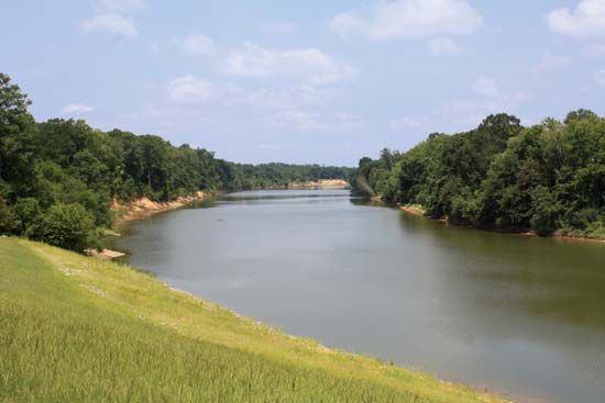
The Big Black River is a waterway that originates in north-central Mississippi, United States. It flows along a southwesterly path for approximately 330…
What is Big Black River?
The Big Black River is a waterway that originates in north-central Mississippi, United States. It flows along a southwesterly path for approximately 330 miles (530 km) before emptying into the Mississippi River at a point 23 miles (37 km) southwest of Vicksburg.1
Please note that this river is distinct from the Black River, which is located in Missouri and Arkansas.2
What is the significance of the Mississippi River to the region?
The Mississippi River is of profound significance to the North American continent, serving as a vital commercial artery, a central geographic feature, and a cultural icon.
Economic and Commercial Importance
As the central river artery of a highly industrialized nation, the Mississippi is one of the world’s busiest commercial waterways. It facilitates the transport of essential bulk goods, including petroleum, coal, iron, steel, and agricultural products. Historically, the river revolutionized trade in the 19th century, becoming the economic “overlord” of the region before the rise of railroads. Today, it remains a critical transport route for cargo ranging from industrial materials to specialized equipment like space research booster rockets.345
Geographic and Hydrological Role
The Mississippi system drains approximately 1.2 million square miles—about one-eighth of North America—uniting the Central and Gulf lowlands. Its massive drainage basin, fed by major tributaries like the Missouri and Ohio rivers, makes it the largest river in North America by volume of discharge. The river’s alluvial plain is a product of its own geological work, illustrating the interdependence of the entire drainage system.637
Cultural and Historical Legacy
The river is deeply woven into the national consciousness of the United States, appearing frequently in literature and folklore. It is famously linked to the works of Mark Twain and the history of the American Civil War, where control of the waterway was a decisive strategic objective.35
Environmental and Flood Management
The river’s power necessitates extensive human modification, including a complex system of levees, dams, and spillways managed by the Mississippi River Commission. While these structures provide flood protection, major events like the floods of 1927, 1993, and 2011 have highlighted the limitations of total control, leading to a modern shift toward “living with the river” and sustainable floodplain management.4389
How do rivers shape the geography of Mississippi?
Rivers have played a fundamental role in shaping the geography of Mississippi, primarily through the processes of erosion, sedimentation, and the creation of distinct landforms.
The Delta and Alluvial Plains
The most prominent geographic feature shaped by rivers is “the Delta,” a fertile crescent in northwestern Mississippi. This region is the ancient floodplain of the Yazoo and Mississippi rivers. Over time, these rivers deposited deep layers of black alluvial soil, creating some of the most productive agricultural land in the state.8
Geological Influence
The physical landscape of the state is heavily influenced by the drainage networks of major river systems, including the Tombigbee, Pearl, and Pascagoula rivers, alongside the Mississippi. These rivers have carved the terrain, creating features such as the loess bluffs that mark the transition from the Delta to the highlands.98
Human Modification
While rivers naturally shaped the region, human intervention has significantly altered these processes. Extensive systems of levees and reservoirs have been constructed to manage flooding and stabilize the landscape. These structures have fundamentally changed the riverine environment, trapping silt that would otherwise naturally replenish the soil and maintain the deltaic landscape.10118
What are the main differences between a river and a tributary?
The primary difference between a river and a tributary lies in their relationship within a drainage basin. A river is a large natural stream of water flowing in a channel to the sea, a lake, or another such stream, while a tributary is a smaller stream or river that flows into a larger one.131415
Key distinctions include:
- Hierarchy: A river acts as the main trunk of a drainage system, whereas a tributary serves as a feeder or branch that contributes its water to that main trunk.1315
- Scale: While a tributary is often smaller than the river it joins, this is not always the case. Some tributaries, such as the Missouri River, are immense in their own right and possess their own network of smaller tributaries.15
- Function: Tributaries collect water from a specific portion of a drainage basin and deliver it to the primary river, which then carries the combined volume of water toward its ultimate destination.1615
Sources
- Big Black River — Encyclopædia Britannica
- Black River — Encyclopædia Britannica
- North America - Drainage — Encyclopædia Britannica
- Mississippi River - Modern commercial activity — Encyclopædia Britannica
- Mississippi River — Encyclopædia Britannica
- Mississippi River - Development of the river’s commerce — Encyclopædia Britannica
- Mississippi River - Hydrology — Encyclopædia Britannica
- Mississippi River - Physiography — Encyclopædia Britannica
- Mississippi River - Flood control — Encyclopædia Britannica
- Mississippi: Top Questions — Encyclopædia Britannica
- Mississippi - Drainage — Encyclopædia Britannica
- Mississippi - Relief and soils — Encyclopædia Britannica
- tributary — Merriam-Webster
- river — Merriam-Webster
- drainage basin — Encyclopædia Britannica
- drainage basin — Merriam-Webster
- tributaries — Merriam-Webster
- Did you know? — Merriam-Webster
- river - Types of waterfalls — Encyclopædia Britannica
Published on · 3 min read