Doubs River
The Doubs River has a total length of 267 miles (430 km). While it is primarily a river in eastern France, it also makes a short incursion into Switzerland…
What is the length of the Doubs River and which countries does it flow through?
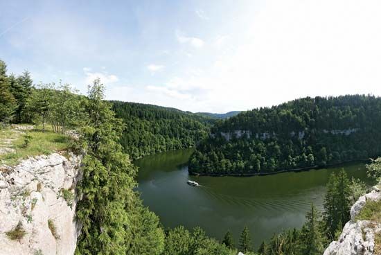
The Doubs River has a total length of 267 miles (430 km). While it is primarily a river in eastern France, it also makes a short incursion into Switzerland during its course incursion into Switzerland during its course.1
What is the historical significance of the Doubs River in the region?
The historical significance of the Doubs River is primarily tied to its role in regional infrastructure and water management.
- Water Supply: Due to the geological nature of the Jura Mountains—where limestone formations often lead to a deficiency of surface water—the deep gorges of the Doubs have historically served as a vital source of water for the region, with modern supply networks now drawing from the river to support local communities.1
- Canalization and Connectivity: The river is linked to the Rhine-Rhône Canal, a waterway constructed between 1810 and 1833. This connection was part of broader historical efforts to improve inland navigation and link major European river systems, facilitating trade and transport across eastern France.23
- Urban Development: The river has shaped the geography of key regional centers. Notably, it loops around the center of Besançon, the capital of the Doubs département, serving as a defining feature of the city’s layout and historical development.2
How is the Doubs River used for transportation, industry, or recreation?
The Doubs River plays a specialized role in the region’s infrastructure and economy, though its utility for large-scale transportation is limited by its geography.
Transportation and Navigation
The river is not a major commercial waterway. Because much of its course is characterized by a torrent-like upper section, waterfalls, and deep gorges, it is navigable for only a few miles above its mouth at the Saône. However, the river is connected to the Rhine-Rhône Canal, which was constructed between 1810 and 1833 to facilitate inland navigation and link major European river systems. This canal remains in use, though it carries only moderate traffic and is limited to smaller, 300-ton craft.
Industry and Water Management
The Doubs is essential for regional water supply. Due to the permeable limestone formations of the Jura Mountains, surface water is often scarce in the surrounding areas. Modern supply networks draw water from the river’s deep gorges to support local communities and agricultural needs.
Recreation
While the provided information does not detail specific recreational activities on the Doubs itself, the broader Jura region—where the river flows—supports a thriving tourist industry. This includes summer tourism and winter sports, which have driven the development of extensive road and rail networks throughout the area.
What are some of the major cities or towns along the Doubs River?
Several notable cities and towns are situated along the course of the Doubs River as it winds through eastern France and briefly into Switzerland:
- Pontarlier: Located in the upper course of the river, this town sits near the Lac de Saint-Point.
- Saint-Ursanne: A picturesque town in Swiss territory, known for the river’s hairpin bend at this location.
- Saint-Hippolyte: A town situated along the river’s westward path.
- Montbéliard: A significant industrial center where the river bends sharply and is joined by the Rhine-Rhône Canal.
- Besançon: The capital of the Doubs département, this city is famously encircled by a horseshoe meander of the river, which serves as a defining feature of its urban layout and history.
- Dole: A historic town that served as the capital of Franche-Comté until 1674; it remains a key commercial and administrative center along the river.
- Verdun-sur-le-Doubs: Located at the confluence where the Doubs flows into the Saône River.
Sources
- Doubs River — Encyclopædia Britannica
- Jura Mountains — Encyclopædia Britannica
- Rhine River - Navigational improvements — Encyclopædia Britannica
- Grand Canal d’Alsace — Encyclopædia Britannica
- Besançon — Encyclopædia Britannica
- Switzerland - Relief and drainage — Encyclopædia Britannica
- Franche-Comté — Encyclopædia Britannica
- Dole — Encyclopædia Britannica
Published on · 3 min read