Kachin Hills
The Kachin Hills are a rugged, forested region in northeastern Myanmar that has historically occupied a unique position in the nation's political landscape.…
How have the Kachin Hills played a role in Myanmar’s history and conflicts?
The Kachin Hills are a rugged, forested region in northeastern Myanmar that has historically occupied a unique position in the nation’s political landscape. Never under the control of traditional Burmese kings, the area was administered directly by the British until independence. Following 1948, the region was established as a semiautonomous unit, though it was later integrated more fully into the state.12
The region is central to Myanmar’s long-standing internal conflicts. Since independence, ethnic armed organizations (EAOs) have fought the central government to secure greater autonomy for minority groups, including the Kachin secure greater autonomy for minority groups, including the Kachin. The Kachin Independence Army (KIA) is a prominent actor in this struggle and currently serves as a formal ally to the National Unity Government (NUG) in the ongoing civil war triggered by the 2021 coup.534
Beyond internal strife, the hills have been a site of geopolitical tension. For centuries, Chinese governments laid claim to parts of the region, a boundary dispute that was not resolved until the early 1960s.1
How do the Kachin Hills influence the water systems and river networks in northern Myanmar?
The Kachin Hills serve as a vital hydrological source for northern Myanmar, acting as the primary drainage area for the headstreams of the Irrawaddy River. Specifically, the region is drained by the Mali and Nmai rivers, which converge to form the main stem of the Irrawaddy.1
To the west of these highlands lies the upper basin of the Chindwin River, another major waterway in the region. These river networks are essential to the area, as they are utilized for transportation throughout the rugged, forested landscape. The drainage basin created by these systems supports diverse populations, with the Kachin people inhabiting the upper reaches where these rivers originate.16
What is the geographical location and extent of the Kachin Hills in Myanmar?
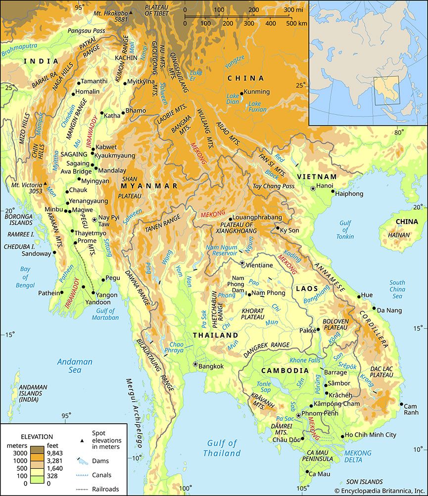
The Kachin Hills are a heavily forested group of highlands located in the northeasternmost section of Myanmar. These mountains follow a north-south orientation and are defined by the following borders:1
- North: The Tibet autonomous region of China.
- East: Yunnan province, China.
- Northwest: Arunachal Pradesh state, India.
- West: The hills blend into the Kumon Range.1
The region is characterized by steep river valleys and serves as the drainage area for the Mali and Nmai rivers, which are headstreams of the Irrawaddy River. The upper basin of the Chindwin River is situated to the west of the highlands. Major population centers within this rugged landscape include the towns of Myitkyina, Mogaung, and Putao.1
What is the highest peak in the Kachin Hills, and how does it compare to other mountains in Myanmar?
The highest peak in Myanmar is Mount Hkakabo, which reaches an elevation of 19,296 feet (5,881 meters). While the Kachin Hills are a distinct highland region in the northeast, Mount Hkakabo serves as the central “knot” where the northern mountain ranges converge.71
Compared to other mountainous regions in Myanmar, the northern mountains—including the area around Mount Hkakabo—are significantly higher than the western ranges and the eastern plateaus:
- Western Ranges: These include the Patkai Range, Naga Hills, and Chin Hills, which have an average elevation of about 6,000 feet (1,800 meters), with some peaks rising to 10,000 feet (3,000 meters) or more.7
- Eastern Plateau: The Shan Plateau has an average elevation of approximately 3,000 feet (900 meters), with longitudinal ranges rising to between 6,000 and 8,600 feet (1,800 to 2,600 meters).7
Mount Hkakabo stands as the country’s most prominent peak, towering well above the elevations found in the southern and central mountain systems.7
Sources
- Kachin Hills — Encyclopædia Britannica
- Myanmar - The unsettled early years, 1948–62 — Encyclopædia Britannica
- Myanmar Civil War - 2022 — Encyclopædia Britannica
- Kachin — Encyclopædia Britannica
- Myanmar Civil War — Encyclopædia Britannica
- Irrawaddy River - People of the Irrawaddy River — Encyclopædia Britannica
- Myanmar - Relief — Encyclopædia Britannica
Published on · 3 min read