Paraguaná Peninsula
The Paraguaná Peninsula, located in the Falcón state of northwestern Venezuela, was historically inhabited by the Caquetío people at the time of the Spanish…
What indigenous cultures have inhabited the Paraguaná Peninsula, and how have they influenced the area?
The Paraguaná Peninsula, located in the Falcón state of northwestern Venezuela, was historically inhabited by the Caquetío people at the time of the Spanish conquest. It is important to clarify that while the peninsula shares a similar name to the country of Paraguay, they are distinct geographic entities; the Guaraní people mentioned in your search results are associated with the history of Paraguay, not the Paraguaná Peninsula.
The Caquetío were intensive farmers who cultivated staples such as corn, sweet potatoes, and manioc in irrigated fields. They lived in villages of thatched huts and were known for their pottery craft. To avoid enslavement by the Spanish, many moved inland, though they were eventually destroyed as a distinct culture.
Today, the peninsula is characterized by its industrial development, particularly the large oil refineries at Amuay and Punta Cardón, rather than the preservation of its original indigenous cultural influence.
What is the historical significance of the Paraguaná Peninsula in Venezuela’s development?
The Paraguaná Peninsula has played a pivotal role in Venezuela’s economic development, transitioning from a colonial-era outpost to a cornerstone of the nation’s industrial infrastructure.
Historical and Economic Significance
During the colonial period, the peninsula’s geography—characterized by its remote, low-lying terrain—served primarily as a haven for pirates and smugglers. However, its significance shifted dramatically in the mid-20th century with the rise of the petroleum industry.1
- Petroleum Hub: Beginning in the 1950s and 1960s, the peninsula became the site of massive oil refinery operations at Amuay and Punta Cardón. These facilities are strategically located on the western shore, where coastal indentations allow for easy access by deep-draft tankers.172
- Industrial Integration: The region functions as a critical node in Venezuela’s energy sector, receiving crude oil and natural gas via pipelines from the fields at Lake Maracaibo from the fields at Lake Maracaibo. Today, this refining complex handles more than two-thirds of the country’s domestic oil refining capacity.18
- Urban Growth: The industrial boom facilitated the emergence of Punto Fijo in the 1960s, which developed into the peninsula’s major urban and industrial center.12
What are the main economic activities on the Paraguaná Peninsula, and how do they impact the region?
The economic landscape of the Paraguaná Peninsula is defined by a mix of traditional agriculture, large-scale industrial activity, and tourism.
Primary Economic Activities
- Petroleum Industry: The most significant economic driver is the oil sector. Since the 1950s and 1960s, the peninsula has served as a major refining hub. Crude oil is transported via pipelines from the Lake Maracaibo fields to massive refineries at Amuay and Punta Cardón. This infrastructure supports a major urban-industrial complex centered around Punto Fijo.18
- Agriculture: Due to the region’s infertile soil and limited fresh water, traditional farming is restricted. Goat raising is a key activity, providing meat, milk, and cheese. Additionally, the region exports goatskins and fertilizer derived from goat excrement.1
- Commerce and Tourism: Punto Fijo benefits from its status as a duty-free zone, attracting shoppers. Furthermore, the peninsula’s scenic beaches are a popular destination for Venezuelan tourists.18
Regional Impact
These activities have transformed the peninsula from a sparsely populated, remote area into a vital industrial center. The development of the oil complex spurred the growth of Punto Fijo as a major urban hub, which is now well-connected by highway to Coro and other mainland cities.18
Where is the Paraguaná Peninsula located in Venezuela, and what are its main geographical features?
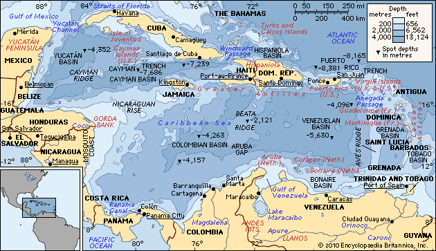
The Paraguaná Peninsula is located in the state of Falcón in northwestern Venezuela. It is the country’s largest peninsula, extending into the Caribbean Sea to the east and the Gulf of Venezuela to the west.21
Geographical Features
- Dimensions: The peninsula spans approximately 40 miles (60 km) from north to south and features about 200 miles (300 km) of coastline.1
- Terrain and Climate: It is characterized by a low elevation and generally infertile soil. The region suffers from a lack of sufficient fresh water, which limits traditional agriculture.1
- Connectivity: The peninsula is linked to the Venezuelan mainland by an isthmus, at the base of which lies the state capital, Coro. The area is well-served by highways that connect its industrial centers to the rest of the country.21
- Coastal Geography: The western shore features coastal indentations that provide deep-water access, which has been essential for the development of large-scale oil refining facilities.110
Sources
- Paraguaná Peninsula — Encyclopædia Britannica
- Falcón — Encyclopædia Britannica
- Caquetío — Encyclopædia Britannica
- Paraguay - Cultural milieu — Encyclopædia Britannica
- history of Paraguay - Early history of Paraguay — Encyclopædia Britannica
- Paraguay - Ethnic groups — Encyclopædia Britannica
- Venezuela - Industry — Encyclopædia Britannica
- Punto Fijo — Encyclopædia Britannica
- Paraguay - Services — Encyclopædia Britannica
- Gulf of Venezuela — Encyclopædia Britannica
Published on · 3 min read