Sunset Crater Volcano National Monument
Visitors to Sunset Crater Volcano National Monument in north-central Arizona can observe several distinct geological features formed by volcanic activity…
What unique geological features can visitors observe at Sunset Crater Volcano National Monument?
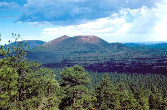
Visitors to Sunset Crater Volcano National Monument in north-central Arizona can observe several distinct geological features formed by volcanic activity that began in 1064–65:
- Cinder Cone: The monument is centered on a truncated cinder cone that rises 1,000 feet above the surrounding landscape.
- Summit Crater: The volcano features a deep, brilliantly hued crater measuring 400 feet deep and approximately 1,280 feet in diameter.
- Lava Formations: The area contains extensive lava flows and lava beds, which include unique ice caves.
These features provide a fascinating look at the region’s volcanic history, situated within the Coconino National Forest near Flagstaff. The site is also connected to the nearby Wupatki National Monument via a scenic loop road.1
How does Sunset Crater Volcano National Monument contribute to our understanding of volcanic processes and ecology?
Sunset Crater Volcano National Monument serves as a vital site for understanding volcanic processes and ecological succession.
Regarding volcanic processes, the monument provides a clear record of a cinder cone formation. By analyzing tree rings from nearby buried Native American pit houses, researchers have precisely dated the initial eruption to the winter of 1064–65, with activity continuing intermittently for approximately 150 years. This allows scientists to study the life cycle of a volcanic event and the resulting geological structures, such as the 400-foot-deep summit crater and extensive lava beds.1
Ecologically, the monument demonstrates how life recolonizes a landscape following a volcanic disturbance. The area now supports distinct vegetation zones, with ponderosa pine forests on higher slopes and piñon pine and juniper at lower elevations. Furthermore, the presence of diverse wildlife, including pronghorn, jackrabbits, and Steller’s jays, highlights the ongoing biological adaptation within this volcanic environment.1
When did the Sunset Crater volcano last erupt, and how did it affect the surrounding landscape?
The Sunset Crater volcano began its formation during an eruption in the winter of 1064–65, with volcanic activity continuing intermittently for approximately 150 years thereafter.1
The eruption significantly transformed the surrounding landscape, creating a cinder cone that rises 1,000 feet above the area. The event left behind a summit crater measuring 400 feet deep and 1,280 feet in diameter, as well as extensive lava flows and lava beds containing ice caves. Over time, the area has undergone ecological succession, now supporting forests of ponderosa pine on higher slopes and piñon pine and juniper at lower elevations, while providing a habitat for wildlife such as pronghorn, jackrabbits, and Steller’s jays.1
How does the ecosystem around Sunset Crater differ from other areas in Arizona due to the volcanic activity?
The ecosystem around Sunset Crater Volcano National Monument is distinct from other areas in Arizona primarily due to the dramatic impact of its volcanic history on the landscape. While much of the surrounding region features established biological communities, the monument is defined by its relatively recent geological disturbance, which necessitated a process of ecological succession to return life to the area.13
Because the volcanic eruptions covered the land in lava and ash, the environment was effectively reset, requiring primary succession to build a new biological community from a barren state. This process involves a predictable sequence where pioneer species colonize the rock, eventually creating soil that allows for more complex vegetation.34
Today, this unique history has resulted in a landscape characterized by:
- Distinct Vegetation Zones: The area features a transition from piñon pine and juniper at lower elevations to ponderosa pine forests on the higher slopes of the cinder cone.1
- Geological Features: The presence of extensive lava beds and ice caves creates microclimates that differ from the typical arid Arizona terrain.1
- Wildlife Adaptation: The evolving habitat supports specific species, including pronghorn, jackrabbits, and Steller’s jays, which have adapted to this volcanic environment.1
Sources
- Sunset Crater Volcano National Monument — Encyclopædia Britannica
- Sunset Crater — Merriam-Webster
- What Is the Difference Between Primary and Secondary Ecological Succession? — Encyclopædia Britannica
- ecological succession: Top Questions — Encyclopædia Britannica
Published on · 3 min read