Abakan River
The Abakan River is a waterway that originates in the Altai Mountains within the republic of Khakassia, Russia. It flows in a northeastward direction for…
What is Abakan River?
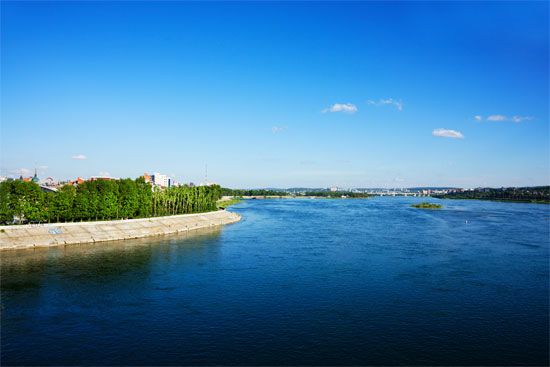
The Abakan River is a waterway that originates in the Altai Mountains within the republic of Khakassia, Russia. It flows in a northeastward direction for approximately 319 miles (514 km) before joining the Yenisey River.1
As a significant tributary of the upper and middle Yenisey, the Abakan is fed primarily by melting snow and rainwater, contributing to high water levels during the spring and summer months. The city of Abakan, which serves as the administrative center of Khakassia, is situated on the left bank of the river near its confluence with the Yenisey. The area surrounding the river’s lower course, known as the Minusinsk Basin, features a broad valley that expands significantly just below the Abakan’s confluence with the Yenisey.23
What is the significance of the Yenisey River system in Russia?
The Yenisey River system is a vital geographical and economic artery in Russia, serving as one of the longest rivers in Asia and the largest in Russia by runoff, discharging approximately 150 cubic miles of water annually into the Kara Sea.45
Economic and Industrial Significance
The system is a cornerstone of Siberian infrastructure:
- Hydroelectric Power: The Yenisey and its major tributary, the Angara River, possess the greatest hydroelectric potential of any river system in Russia. Major power stations at Krasnoyarsk, Irkutsk, Bratsk, and Sayan provide a combined generating capacity exceeding 25 million kilowatts.6
- Navigation and Trade: The river is a key transport route for lumber, coal, petroleum products, and machinery. It is navigable from Oznachennoye to the sea, with major ports including Igarka and Krasnoyarsk.6
- Resource Extraction: The basin supports traditional livelihoods like reindeer breeding and fishing, alongside significant mining operations for coal and nonferrous ores near Norilsk.6
Hydrological Scale
Draining a basin of 996,000 square miles, the system includes roughly 20,000 tributaries. Its hydrological regime is defined by violent spring floods and significant ice activity, which necessitates careful management of its vast water resources.74
What are the main characteristics of the Altai Mountains?
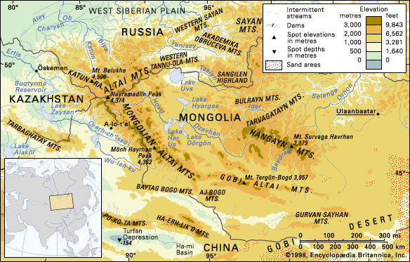
The Altai Mountains are a complex, 1,200-mile-long mountain system in Central Asia, spanning Russia, China, Mongolia, and Kazakhstan. The name derives from the Turkic-Mongolian word altan, meaning “golden.”9
Geological Features
The range was formed by ancient orogenic upthrusts and later shaped by Quaternary Period glaciation, which carved rugged, U-shaped valleys. The system remains tectonically active, with frequent earthquakes along fault zones. The landscape features high, steep peaks—such as Mount Belukha at 14,783 feet—alongside structural hollows filled with steppe landscapes. The region is rich in mineral resources, including gold, mercury, iron, and tungsten.10
Vegetation Zones
The mountains exhibit four distinct ecological zones:11
- Mountain subdesert: Found in the Mongolian and Gobi Altai, characterized by drought- and salt-tolerant plants.11
- Mountain steppe: Composed of meadows, sod grasses, and shrubs.11
- Mountain forest: Dominant in the Altai proper, featuring coniferous forests like larch, fir, and pine.11
- Alpine regions: High-altitude areas consisting of subalpine shrubs, meadows, mosses, and bare rock.11
How do rivers like the Abakan contribute to the geography of the Minusinsk Basin?
The Abakan River plays a significant role in the geography of the Minusinsk Basin by serving as a major tributary that influences the physical characteristics of the Yenisey River.
As the Yenisey flows out of the mountains at Oznachennoye and enters the Minusinsk Basin, it broadens its valley significantly. The confluence of the Abakan is a key point in this transition; just below where the Abakan joins the Yenisey, the river valley expands to more than 3 miles (5 km) in width. The riverbed itself, measuring about 500 yards (460 meters) across, becomes studded with islands, and the flow velocity is notably reduced to approximately 6 feet (2 meters) per second as the river enters the Krasnoyarsk Reservoir area.1
Fed primarily by rainwater and melting snow, the Abakan and other regional tributaries contribute to the seasonal hydrological cycle of the basin, experiencing high water levels in late April followed by summer rain floods.1
Sources
- Abakan River — Encyclopædia Britannica
- Yenisey River - Physiography — Encyclopædia Britannica
- Abakan — Encyclopædia Britannica
- Yenisey River - Hydrology of the Yenisey River — Encyclopædia Britannica
- Yenisey River - Climate — Encyclopædia Britannica
- Yenisey River - Economy — Encyclopædia Britannica
- Yenisey River - Physical features — Encyclopædia Britannica
- Yenisey River — Encyclopædia Britannica
- Altai Mountains — Encyclopædia Britannica
- Altai Mountains - Geology — Encyclopædia Britannica
- Altai Mountains - Plant life — Encyclopædia Britannica
- Russia - The mountains of the south and east — Encyclopædia Britannica
Published on · 3 min read