Amatique Bay
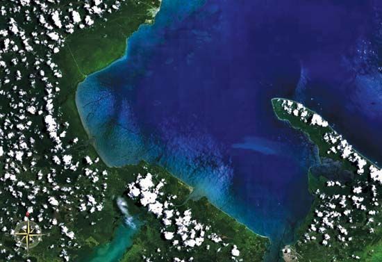
Amatique Bay is an inlet of the Gulf of Honduras located in the Caribbean Sea. It indents the coastlines of eastern Guatemala and southeastern Belize.
What is Amatique Bay?
Amatique Bay is an inlet of the Gulf of Honduras located in the Caribbean Sea. It indents the coastlines of eastern Guatemala and southeastern Belize.1
The bay stretches approximately 40 miles (64 km) northwest from Santo Tomás de Castilla and measures about 15 miles (24 km) across from northeast to southwest. It serves as a vital hydrological outlet, receiving water from three primary rivers: the Dulce River (which drains Izabal Lake), the Sarstoon River (marking the border between Belize and Guatemala), and the Moho River.1
The region is significant for its maritime commerce, hosting several key ports, including Puerto Barrios, Santo Tomás de Castilla, and Livingston in Guatemala, as well as Punta Gorda in Belize.12
What is the importance of the Gulf of Honduras?
The Gulf of Honduras is a vital maritime inlet of the Caribbean Sea that serves as a critical hub for regional trade and economic activity. Stretching between Belize and Honduras, the gulf facilitates international commerce through several major ports, most notably Puerto Cortés in Honduras and Santo Tomás de Castilla and Puerto Barrios in Guatemala.34
The importance of the gulf is defined by:
- Trade and Logistics: Puerto Cortés features one of the most advanced container facilities in Central America, handling a significant portion of Honduran exports, including coffee, bananas, and various industrial goods.4
- Economic Connectivity: The gulf acts as a gateway for the Sula Valley and other industrial centers, linking them to global markets via rail and highway networks.4
- Ecological and Resource Value: The region supports diverse ecosystems, including mangroves and reefs, and sustains a developing fishing industry, particularly for shrimp and lobster, which are key exports to the United States.56
How do the rivers flowing into Amatique Bay affect the local environment?
The rivers flowing into Amatique Bay—the Dulce, Sarstoon, and Moho—act as primary conduits for water, sediments, and potential pollutants entering the coastal environment. While specific localized data for these rivers is limited, the general impact of riverine discharge into coastal ecosystems is well-documented.19
Rivers often transport runoff from inland areas, which can include fertilizers and pesticides used in agriculture. When these nutrient-rich waters reach the bay, they can trigger excessive growth of phytoplankton. As these organisms die and decompose, they consume dissolved oxygen, potentially creating “dead zones” that threaten bottom-dwelling marine life such as shrimp and crabs. Furthermore, pollution from industrial or agricultural sources can degrade the water quality of estuaries, which are critical habitats for diverse marine species. Such nutrient enrichment and chemical contamination are known to contribute to the decline of coral reefs and the proliferation of harmful algal blooms in the broader Caribbean Sea region.9
What role do the ports of Puerto Barrios and Santo Tomás de Castilla play in Guatemala’s economy?
The ports of Santo Tomás de Castilla and Puerto Barrios are essential components of Guatemala’s economic infrastructure, serving as the nation’s primary gateways for maritime trade on the Caribbean coast.
- Santo Tomás de Castilla: Developed by the Guatemalan government to reduce reliance on foreign-controlled facilities, this deepwater port is currently the busiest in the country. It serves as the primary hub for handling general cargo and features a free trade and industrial zone established in 1975. It is also the headquarters of the Guatemalan navy and is well-connected to Guatemala City via rail, highway, and air.10211
- Puerto Barrios: Historically the principal port for shipping agricultural commodities, particularly bananas, this town remains specialized in the export of agricultural produce. While its dominance was challenged by the development of the nearby Santo Tomás facility, it remains a vital link in the country’s transportation network, connected to the capital by a primary north-south highway.10211
Together, these ports facilitate the majority of Guatemala’s foreign trade, supporting the movement of key exports like coffee, sugar, and bananas to international markets.1112
Sources
- Amatique Bay — Encyclopædia Britannica
- Puerto Barrios — Encyclopædia Britannica
- Gulf of Honduras — Encyclopædia Britannica
- Puerto Cortés — Encyclopædia Britannica
- Honduras - Agriculture, forestry, and fishing — Encyclopædia Britannica
- Gulf of Fonseca — Encyclopædia Britannica
- Honduras — Encyclopædia Britannica
- Honduras - Plant and animal life — Encyclopædia Britannica
- conservation - Pollution — Encyclopædia Britannica
- Santo Tomás de Castilla — Encyclopædia Britannica
- Guatemala - Transportation and telecommunications — Encyclopædia Britannica
- Guatemala - Trade — Encyclopædia Britannica
Published on · 3 min read