Anegada Passage
The Anegada Passage is a 40-mile (65 km) wide channel located in the West Indies that serves as a vital connection between the Atlantic Ocean and the…
What is Anegada Passage?
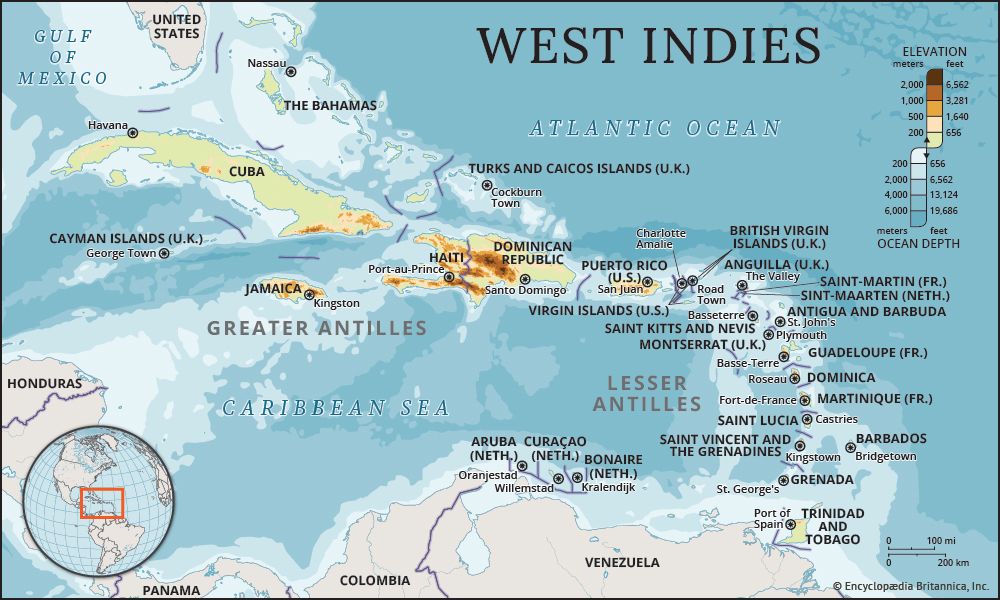
The Anegada Passage is a 40-mile (65 km) wide channel located in the West Indies that serves as a vital connection between the Atlantic Ocean and the Caribbean Sea.1
Situated between the British Virgin Islands to the west and the Leeward Islands to the southeast, it holds the distinction of being the deepest channel in the eastern Caribbean, with depths exceeding 7,550 feet (2,300 m).1
Beyond its geography, the passage is oceanographically significant as one of two primary routes—alongside the Windward Passage—through which subsurface water enters the Caribbean basin. Its sill depth, which regulates this water exchange, ranges between 6,400 and 7,700 feet (1,950 and 2,350 meters).12
What is the Windward Passage?
The Windward Passage is a 50-mile (80 km) wide strait in the West Indies that connects the Atlantic Ocean to the Caribbean Sea. It separates Cuba to the west from Hispaniola to the southeast, with the Jamaica Channel serving as its southwestern extension.3
This passage is a critical maritime corridor, forming part of the direct shipping route between the east coast of the United States and the Panama Canal.3
From an oceanographic perspective, the Windward Passage is one of two primary gateways—alongside the Anegada Passage—through which subsurface water enters the Caribbean basin. It features a threshold depth of approximately 5,500 feet (1,700 m), with a specific sill depth ranging between 5,250 and 5,350 feet (1,600 and 1,630 meters). North Atlantic deep water, noted for its high oxygen content, enters the Caribbean through this passage to fill the Yucatán, Cayman, and Colombian basins.234
How do ocean currents affect the Caribbean Sea?
Ocean currents play a fundamental role in the hydrology and physical characteristics of the Caribbean Sea, influencing everything from water temperature to the global circulation of the Atlantic Ocean.
Surface Circulation
The powerful Caribbean Current is a primary surface feature, formed by the junction of the North Equatorial and Guiana currents. Driven by trade winds, these surface waters enter through the southern Antilles and are forced westward before exiting through the Yucatán Channel into the Gulf of Mexico. This accumulation of water creates a hydrostatic head that serves as a major driving force for the Gulf Stream.452
Deep-Water Exchange
The Caribbean’s deep basins are regulated by subsurface currents entering through specific passages:
- Windward Passage: Allows high-oxygen North Atlantic deep water to enter and fill the Yucatán, Cayman, and Colombian basins.46
- Anegada Passage: Facilitates the entry of Subantarctic intermediate water at shallower depths.46
Because the shallow sills of the Antillean arc block colder Antarctic bottom water, the Caribbean’s bottom temperature remains relatively warm at approximately 39 °F (4 °C), compared to the much colder Atlantic depths.4
What are the Leeward Islands?
The term Leeward Islands most commonly refers to the northern arc of the Lesser Antilles in the West Indies, located at the northeastern end of the Caribbean Sea. The name reflects the region’s position relative to the prevailing easterly trade winds, which reach these islands after passing the Windward Islands to the south.89
The major islands in this chain include:
- United States Virgin Islands and British Virgin Islands
- Anguilla
- Saint Martin
- Saint-Barthélemy
- Saba
- Sint Eustatius
- Saint Kitts and Nevis
- Antigua and Barbuda
- Montserrat
- Guadeloupe8
It is important to note that the name “Leeward Islands” is also used for other geographical locations, including an island chain in the central Pacific and the western group of the Society Islands in the South Pacific9.
Sources
- Anegada Passage — Encyclopædia Britannica
- Caribbean Sea - Physiography — Encyclopædia Britannica
- Windward Passage — Encyclopædia Britannica
- Caribbean Sea - Hydrology — Encyclopædia Britannica
- Caribbean Current — Encyclopædia Britannica
- Caribbean Sea - Study and exploration — Encyclopædia Britannica
- Atlantic Ocean - The North Atlantic — Encyclopædia Britannica
- Leeward Islands — Encyclopædia Britannica
- Leeward Islands — Merriam-Webster
- Lesser Antilles — Encyclopædia Britannica
- Windward Islands — Encyclopædia Britannica
Published on · 3 min read