Belait River
The Belait River is a short stream located on the island of Borneo within the nation of Brunei. Situated near the country's southwestern border with the…
What is Belait River?
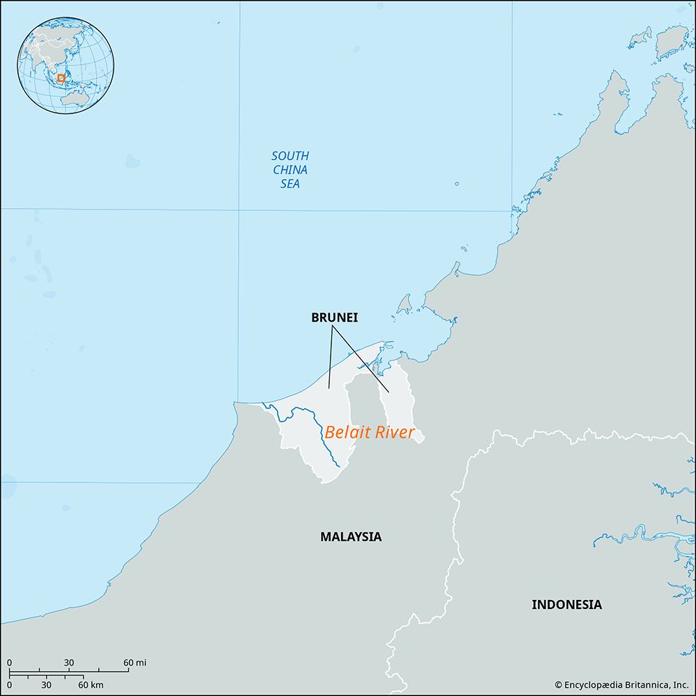
The Belait River is a short stream located on the island of Borneo within the nation of Brunei. Situated near the country’s southwestern border with the Malaysian state of Sarawak, the river flows for approximately 20 miles (32 km) through swampy terrain before discharging into the South China Sea.1
At the river’s mouth lies Kuala Belait, which serves as a significant town for Brunei and functions as the hub for a nearby offshore oilfield.1
What is the geography of Brunei like?
Brunei’s geography is defined by a transition from a narrow northern coastal plain to rugged, forested hills in the south. The country’s highest point is Pagon Peak, reaching 6,070 feet (1,850 meters) in the southeast.2
Drainage and Soils
The landscape is drained by several rivers that flow northward into the South China Sea, including the Belait, Tutong, and Brunei rivers in the west, and the Pandaruan and Temburong rivers in the east. The Belait is the country’s largest river. While most of Brunei’s soils are deeply weathered and infertile, richer alluvial soils are found along riverbanks and coastal floodplains, providing the best potential for agriculture.2
Climate
Brunei experiences an equatorial climate influenced by monsoon winds. Temperatures remain warm year-round, typically ranging from the mid-70s F (about 23 °C) to 90 °F (32 °C). Annual rainfall is significant, averaging 115 inches (2,900 mm) in coastal areas and exceeding 150 inches (3,800 mm) inland.3
How does the oil industry impact Brunei’s economy?
The petroleum industry is the cornerstone of Brunei’s economy, generating more than half of the nation’s GDP. This reliance on petroleum and natural gas has provided citizens with one of the highest per capita incomes in Asia.53
Key impacts include:
- Export Dominance: Nearly all produced oil and gas are exported, with liquefied natural gas (LNG) serving as a primary source of export earnings.5
- Economic Vulnerability: Because the economy is almost entirely dependent on a single commodity, it remains highly susceptible to global market fluctuations.3
- Import Dependency: Due to this focus, the country relies heavily on imports for most food and manufactured goods.3
- Labor Dynamics: While the industry drives the economy, it employs only a small fraction of the labour force5.
To ensure long-term stability, the government has actively sought to diversify into sectors like agriculture, fisheries, tourism, and financial services.3
What are the major rivers on the island of Borneo?
The island of Borneo is characterized by a dense network of rivers that serve as essential lifelines for trade, commerce, and transportation between coastal areas and the forested interior.78
Major Rivers of Kalimantan (Indonesia)
- Kapuas River: The chief waterway of western Borneo, it flows 710 miles (1,143 km) through West Kalimantan to the South China Sea.97
- Mahakam River: A primary river located in the eastern part of the island.7
- North Kalimantan Rivers: The region features several rivers, including the Sebuku, Sembakung, Sesayap, Kayan, and Bahau, which flow eastward into the Celebes Sea.10
Major Rivers of East Malaysia
- Rajang River: Located in Sarawak, this is the longest river in the state, stretching approximately 350 miles (563 km) to the South China Sea.811
- Kinabatangan River: The longest river in Sabah, it flows 350 miles (563 km) northeastward to the Sulu Sea.128
- Baram River: A significant river in northwestern Borneo that flows 250 miles (400 km) through primary rainforest to the South China Sea.13
Sources
- Belait River — Encyclopædia Britannica
- Brunei - Relief, drainage, and soils — Encyclopædia Britannica
- Brunei - Economy of Brunei — Encyclopædia Britannica
- Brunei - Climate — Encyclopædia Britannica
- Brunei - Resources and power — Encyclopædia Britannica
- Brunei - Settlement patterns — Encyclopædia Britannica
- Kapuas River — Encyclopædia Britannica
- Borneo - Land — Encyclopædia Britannica
- North Kalimantan — Encyclopædia Britannica
- Kinabatangan River — Encyclopædia Britannica
- Baram River — Encyclopædia Britannica
- Malaysia - Drainage — Encyclopædia Britannica
- Sarawak — Encyclopædia Britannica
- Rajang River — Encyclopædia Britannica
Published on · 3 min read