Baram River
The Baram River is a significant waterway located in northwestern Borneo. It originates in the Iran Mountains and travels 250 miles (400 km) in a west and…
What is Baram River?
The Baram River is a significant waterway located in northwestern Borneo. It originates in the Iran Mountains and travels 250 miles (400 km) in a west and northwest direction, primarily winding through rain forest before emptying into the South China Sea at Baram Point.1
As the second longest river in Sarawak, its course is characterized by gorges and rapids that hinder navigation for the majority of its length, excluding the lowest 100 miles. Its primary tributaries include the Patah, Palutan, Apoh, and Bakong rivers.1
What is the significance of the Iran Mountains in Borneo?
The Iran Mountains in Borneo serve as a critical geographical and hydrological feature of the island. They form part of the mountainous backbone that acts as a divide between East Malaysia (Sarawak and Sabah) and the Indonesian territory of Kalimantan.23
The significance of the Iran Mountains includes:
- Hydrological Source: The range serves as the headwaters for major river systems in the region. For instance, the Rajang River, which is vital for transport and agriculture in Sarawak, rises in these mountains before flowing toward the South China Sea.2
- Topographic Barrier: The mountains are part of an eroded, complex landscape of plateaus, gorges, and ravines that define the interior of Borneo. This rugged terrain creates natural boundaries and contributes to the isolation of certain interior regions, such as the areas inhabited by the Iban people, where access is often limited to riverine transport.32
It is important to note that these mountains in Borneo are distinct from the mountain ranges located in the country of Iran, such as the Alborz Mountains or the Zagros Mountains, which are separate geological features entirely.456
How do rain forests impact the flow of rivers?
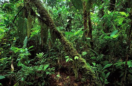
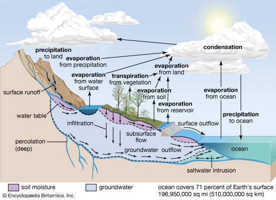
Rain forests play a vital role in regulating the hydrologic cycle and managing the flow of rivers. By acting as both filters and sponges, forests and their associated soil and litter layers ensure that water yields are gradual, reliable, and uniform, which helps prevent the rapid, high-volume flows characteristic of sparsely vegetated land.9
Key impacts include:
- Flow Regulation: Forests intercept precipitation through their canopy and foliage, reducing the amount of water that reaches the ground immediately. This process, along with soil infiltration and transpiration, helps moderate streamflow and lessens the risk of floods.910
- Water Quality: Forested watersheds act as natural filters, producing water that is relatively pure, high in oxygen, and low in temperature. Conversely, the removal of forest cover can lead to increased turbidity and sediment runoff, which degrades water quality.9
- Soil Stabilization: Trees and their root systems stabilize soil and protect stream banks from erosion, preventing washouts that would otherwise alter river channels and increase suspended solids in the water.910
What are the main economic activities in Sarawak?
The economy of Sarawak is diverse, balancing traditional agricultural practices with significant industrial and resource-based activities.
Agriculture and Forestry
Agriculture remains a cornerstone of the state’s economy. In the coastal zones, production focuses on cash crops such as rubber, pepper, and sago, while the interior is characterized by subsistence and shifting agriculture, alongside widespread rice cultivation.14
Forestry is also a major economic driver. Sarawak, along with Sabah, accounts for the majority of Malaysia’s timber production, primarily sourced from lowland evergreen tropical rain forests. Efforts are currently focused on transitioning from raw log exports toward value-added wood-based industries, such as the manufacturing of plywood and furniture.15
Energy and Industry
Sarawak is a significant contributor to Malaysia’s energy sector. Offshore areas off the northeast coast are rich in petroleum and natural gas, which are among the state’s primary exports. Additionally, the state has invested in large-scale hydroelectric projects, such as the dam on the Balui River, to harness the potential of its interior highlands.16
Manufacturing industries in the region include sawmilling, the processing of agricultural products (sago, copra, and pepper), and the production of textiles, metal containers, soap, tiles, and small boats.14
Sources
- Baram River — Encyclopædia Britannica
- Main Range — Encyclopædia Britannica
- Rajang River — Encyclopædia Britannica
- Iran - Flora — Encyclopædia Britannica
- Alborz Mountains — Encyclopædia Britannica
- Iran - Relief of Iran — Encyclopædia Britannica
- Malaysia - Relief — Encyclopædia Britannica
- Zagros Mountains — Encyclopædia Britannica
- forestry - Watershed management and erosion control — Encyclopædia Britannica
- Tree - The importance of trees — Encyclopædia Britannica
- river - Principles governing distribution and flow — Encyclopædia Britannica
- Tropical rainforest - Environment — Encyclopædia Britannica
- Status of the world’s tropical forests - Global implications of deforestation — Encyclopædia Britannica
- Malaysia - Resources and power — Encyclopædia Britannica
- Sarawak — Encyclopædia Britannica
- Malaysia - Agriculture, forestry, and fishing — Encyclopædia Britannica
Published on · 3 min read