Cader Idris
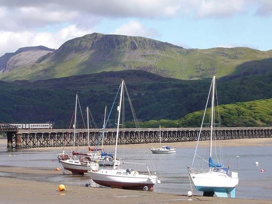
Cader Idris is a prominent mountain ridge located in the county of Gwynedd, Wales. Situated south of the town of Dolgellau and the Mawddach Estuary, it…
What is Cader Idris?
Cader Idris is a prominent mountain ridge located in the county of Gwynedd, Wales. Situated south of the town of Dolgellau and the Mawddach Estuary, it reaches an elevation of 2,927 feet (892 metres).1
The mountain is composed of various volcanic rocks and is noted for its striking examples of glacial erosion. Due to its spectacular scenery, it serves as a popular tourist destination within the southern region of Snowdonia National Park.1
What is the legend of the giant Idris?
The name Cader Idris translates from Welsh to “Idris’s Chair” or “Idris’s Seat.” According to local folklore, the mountain is named after a legendary giant named Idris, who was said to be a warrior-poet or a prince. Legend suggests that the mountain served as his massive stone chair, from which he would sit and gaze at the stars to contemplate the heavens.
While the mountain is a real geological formation composed of volcanic rock and shaped by glacial erosion, the myth of the giant Idris remains a significant part of Welsh cultural heritage, adding a sense of wonder to the landscape of Snowdonia National Park.1
How do glaciers shape mountain landscapes?
Glaciers act as powerful agents of landscape transformation through two primary processes: abrasion and plucking (or quarrying). As ice moves under the influence of gravity, it incorporates rock debris into its base, functioning like a massive sheet of sandpaper that grinds, polishes, and striates the underlying bedrock. Simultaneously, plucking removes larger blocks of rock from the glacier bed, often facilitated by pressure changes and the refreezing of meltwater.234
These processes reshape mountain terrain into distinct landforms:
- Cirques: Amphitheatre-shaped hollows carved into mountainsides, often containing small lakes known as tarns.2
- U-shaped Valleys: Glaciers widen and deepen existing V-shaped stream valleys, creating characteristic parabolic profiles with steep sidewalls and flat bottoms.2
- Arêtes and Horns: As multiple cirques erode a mountain, they leave behind sharp, knife-edge ridges called arêtes. When these cirques form in a radial pattern, they isolate a sharp, pyramidal peak known as a horn.2
These dramatic features are prominent in regions like Snowdonia National Park, where intense glaciation during the Pleistocene Epoch sculpted the rugged mountain massifs.56
What other mountains are in Snowdonia National Park?
Snowdonia National Park, also known as Eryri National Park, is home to several significant mountain massifs beyond the central peaks of Snowdon.
The most prominent mountain outside of the Snowdon massif is Cader Idris, a long mountain ridge located further south in the park. Its highest point, Pen-y-Gader, reaches an elevation of 2,927 feet (892 meters) and overlooks the town of Dolgellau.5
While Snowdon itself is the highest point in Wales and England, it is composed of approximately five main peaks connected by sharp ridges, including its summit, Yr Wyddfa. The park’s landscape is defined by these rugged, volcanic rock formations and deep valleys, which were heavily sculpted by glaciers during the Ice Age.75
Sources
- Cader Idris — Encyclopædia Britannica
- glacial landform - Cirques , tarns, U-shaped valleys, arêtes, and horns — Encyclopædia Britannica
- glacial landform - Glacial erosion — Encyclopædia Britannica
- erosion — Encyclopædia Britannica
- Snowdon — Encyclopædia Britannica
- Wales - Relief — Encyclopædia Britannica
- Eryri National Park — Encyclopædia Britannica
Published on · 2 min read