Canvey Island
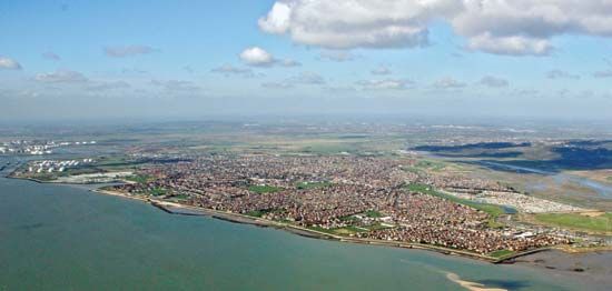
Canvey Island is a low-lying island situated on the north shore of the Thames estuary within the Castle Point borough of Essex, England. It is linked to the…
What is Canvey Island?
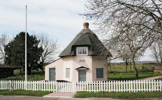
Canvey Island is a low-lying island situated on the north shore of the Thames estuary within the Castle Point borough of Essex, England. It is linked to the mainland via bridges at South Benfleet.1
The island has a long history of managing tidal flooding, with marine defenses originally built by a Dutch engineer in 1623. It remains particularly noted for the devastating floods of 1953, which led to significant improvements in its levee systems. Additionally, Canvey Island holds historical industrial significance as the site of the world’s first marine terminal for imported liquefied natural gas, established in 1959, with facilities later adapted for liquefied petroleum gas.1
How do sea walls and levees protect low-lying islands?
Sea walls and levees are critical engineering structures used to protect low-lying islands and coastal areas from inundation by rivers or the sea.
Levees and Embankments
A levee is a low ridge or earthen embankment built along the edges of a water channel to prevent flooding of adjacent land. These structures are typically constructed from dirt and designed with sufficient width to resist collapse or erosion when saturated. To maintain their integrity, they are often covered with matlike vegetation, such as grass, which helps minimize erosion. In some regions, levees are raised and reinforced over time to combat rising water levels or land subsidence.234
Sea Walls and Barriers
Sea walls and specialized barriers are designed to withstand the destructive power of storm surges and high tides. Modern approaches often involve:15
- Adjustable Barriers: Structures like the Thames Barrier or the Oosterscheldedam feature massive, movable gates that remain open during normal weather to allow tidal flow but can be closed during severe storms to block surges.14
- Dikes and Dams: These are used to close off estuaries or shorten vulnerable coastlines, effectively reducing the area exposed to the sea.15
- Reinforcement: Ongoing maintenance, such as building higher and wider dikes, is essential to adapt to long-term threats like sea-level rise caused by climate change.1
What caused the major North Sea flood of 1953?
The North Sea flood of January 31 to February 1, 1953, was caused by a powerful combination of meteorological and structural factors. Hurricane-force winds blowing over the North Sea generated a massive storm surge, which pushed a wall of water toward the coasts of the Netherlands and England.4
Several critical vulnerabilities exacerbated the disaster:
- Structural Weakness: In the Netherlands, many dikes were in urgent need of repair following damage sustained during World War II, leading to the collapse of over 50 dikes and more than 60 miles of seawalls.4
- Lack of Communication: Neither country possessed a central agency responsible for issuing flood warnings at the time. Furthermore, the rapid destruction of telephone lines prevented communities from being alerted to the storm’s severity.4
- Environmental Conditions: The North Sea’s shallow depths and strong tidal currents, combined with severe winter storms, created the ideal conditions for such a catastrophic surge.8
The tragedy prompted major infrastructure reforms, including the Delta Project in the Netherlands and the construction of the Thames Barrier in the United Kingdom.4
Why is the Thames estuary important for trade and energy?
The Thames estuary has historically served as a vital hub for trade, though its role has evolved significantly over time. For centuries, the River Thames was the principal center of British seaborne trade, with the London Docklands acting as the heart of the city’s economy. Its position as a major port was supported by the development of extensive dock systems and wharves that facilitated the movement of goods into the heart of London.910
Following the decline of traditional port operations in central London after World War II, commercial activity shifted downstream to Tilbury, which was better equipped to handle modern container ships and large tankers. While the provided search results detail the estuary’s long-standing importance as a site for harbors and commerce, they do not contain specific information regarding the estuary’s role in energy production.1110912
The estuary remains a significant geographic feature, with a drainage basin covering nearly 4,000 square miles, and it continues to be managed through complex infrastructure like the Thames Barrier to protect the region from tidal surges.1314
Sources
- Canvey Island — Encyclopædia Britannica
- levee — Encyclopædia Britannica
- Delta Works — Encyclopædia Britannica
- North Sea flood — Encyclopædia Britannica
- levees — Merriam-Webster
- London - Flood control — Encyclopædia Britannica
- levee — Merriam-Webster
- Why is the North Sea so dangerous? — Encyclopædia Britannica
- River Thames - Economic factors — Encyclopædia Britannica
- London Docklands — Encyclopædia Britannica
- estuary - Commercial importance — Encyclopædia Britannica
- United Kingdom - Drainage — Encyclopædia Britannica
- London - Shipping — Encyclopædia Britannica
- River Thames - Physical features — Encyclopædia Britannica
Published on · 3 min read