Chesil Beach
Chesil Beach is a prominent natural feature located in the county of Dorset, England. Stretching 18 miles (29 km) from Bridport to the Isle of Portland, this…
What is Chesil Beach?
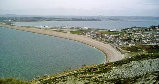
Chesil Beach is a prominent natural feature located in the county of Dorset, England. Stretching 18 miles (29 km) from Bridport to the Isle of Portland, this beach is composed almost entirely of shingle, specifically hard flint or chert rock.1
A defining characteristic of the beach is the lateral sorting of its pebbles. The size of the stones increases significantly along its length, ranging from pea-sized at the northwestern end to an average diameter of 2 inches (5 cm) near Portland. Additionally, for a 12-mile (19 km) stretch between Abbotsbury and Portland, the beach is separated from the mainland by a lagoon.1
How does longshore drift create shingle beaches?
Shingle beaches, which are composed of gravel or pebbles rather than sand, are formed through the process of sediment transport along the coast. This movement is primarily driven by longshore currents, which are generated when waves approach the shore at an acute angle rather than parallel to it.2
As waves break and surge up the foreshore, they pick up sediment—including shingle—from the bottom. The resulting longshore current then transports this material along the shoreline. When this sediment is carried along the coast, it can accumulate to form various depositional features, such as a spit. If a spit continues to grow, it may eventually develop into a bay-mouth barrier, which can enclose a lagoon behind it.234
The physical characteristics of these beaches, such as their slope, are influenced by the grain size of the material; generally, coarser sediment like shingle results in a steeper foreshore compared to sand beaches.3
What is the Fleet Lagoon and how was it formed?
The Fleet Lagoon (often referred to simply as The Fleet) is a brackish body of water located in Dorset, England. It is situated behind the 18-mile-long Chesil Beach, specifically separating the beach from the mainland for a 12-mile (19 km) stretch between Abbotsbury and the Isle of Portland.11
The formation of the Fleet is linked to the development of Chesil Beach as a barrier. In coastal geography, lagoons often form when material carried along the shore creates a spit that eventually extends into a bay-mouth barrier, effectively enclosing a body of water against the mainland. In the case of the Fleet, this barrier is composed of shingle (pebbles). As long as the barrier maintains its elevation above the sea, the lagoon persists, though such features are dynamic and can eventually be filled with sediment over time.1
Why are the pebbles on Chesil Beach sorted by size?
The lateral sorting of shingle on Chesil Beach is a remarkable natural phenomenon. While the provided search results confirm that the beach exhibits a distinct gradient—with pea-sized stones at the northwestern end and stones averaging 2 inches (5 cm) in diameter near the Isle of Portland—the specific physical mechanisms governing this precise size-sorting are not detailed in the available documentation.
We know that waves and longshore currents are the primary forces responsible for transporting sediment along the coast, with larger waves capable of moving larger rock material. However, the exact hydrodynamic processes that result in the consistent, progressive sorting observed at this specific location remain a subject of ongoing study in coastal geomorphology.14
Sources
- Chesil Beach — Encyclopædia Britannica
- shore drift — Merriam-Webster
- coastal landforms - Landforms of depositional coasts — Encyclopædia Britannica
- coastal landforms - Longshore currents — Encyclopædia Britannica
- lagoon - Waves , tides, and surf — Encyclopædia Britannica
- coastal landforms - Beaches — Encyclopædia Britannica
- coastal landforms - Waves — Encyclopædia Britannica
Published on · 2 min read