Coast Mountains
The Coast Mountains are a major segment of the Pacific mountain system in western North America. Extending approximately 1,000 miles (1,600 km) through…
What is Coast Mountains?
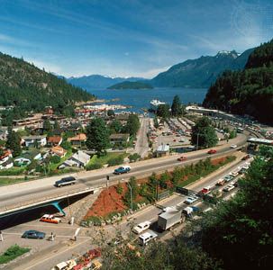
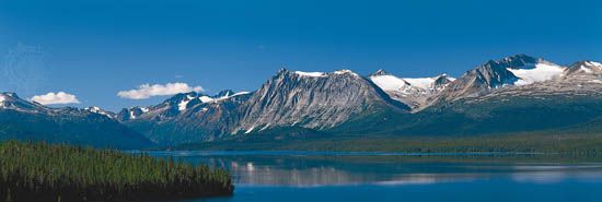
The Coast Mountains are a major segment of the Pacific mountain system in western North America. Extending approximately 1,000 miles (1,600 km) through western British Columbia, Canada, the range stretches from the Yukon border to the Fraser River.1
These mountains are characterized by rugged, glaciated terrain, with many peaks exceeding 11,000 feet (3,400 m). The highest point is Mount Waddington, which reaches 13,176 feet (4,016 m). Glacial activity has carved deep, canyonlike valleys, resulting in a spectacular fjorded coastline. The region experiences heavy precipitation, supporting dense coniferous forests.12
It is important to distinguish the Coast Mountains from the Coast Ranges, which are a separate series of mountains running parallel to the Pacific coast primarily within the United States. While both are part of the same larger mountain system, they are distinct geographical features.312
How do glaciers help create fjords?
Fjords are created through the powerful erosive force of glaciers acting upon coastal valleys. As massive, thick glaciers move through these valleys, they carve out deep, characteristic U-shaped valleys by grinding against the bedrock through abrasion and plucking.67
Because glaciers are heaviest and most active near their source, they are capable of eroding the valley floor to depths far below sea level. This intense glacial erosion creates the deep, narrow basins that define a fjord. Once the glaciers melt, the rising ocean waters inundate these deep, glaciated troughs, transforming them into the long, narrow arms of the sea known as fjords.678
These features often feature a shallow “threshold” or sill at their mouth, which is composed of glacial deposits left behind as the ice retreated. Because of their glacial origin, fjords typically possess steep, vertical walls and remain remarkably deep throughout much of their length.967
What is the difference between the Coast Mountains and the Cascade Range?
The Coast Mountains and the Cascade Range are distinct segments of the Pacific mountain system, forming the eastern side of its elongated, H-shaped arrangement.311
Structural and Geological Differences
- Composition: The Coast Mountains and the North Cascades are structurally similar, consisting of a dissected upland of late Paleozoic rock (approximately 300 million years old) that has been folded, metamorphosed, and intruded by granites. In contrast, the Middle Cascades are a younger, uplifted, and faulted region composed of Cenozoic volcanic layers, such as tuffs, breccias, and andesites.3
- Volcanism: The Cascade Range is defined by prominent volcanic peaks, including Mount Rainier and Mount Hood, which rise significantly above the general surface relief. While the North Cascades also feature volcanic cones like Mount Baker, the Coast Mountains are primarily characterized by their rugged, glaciated terrain and fjorded coastline rather than active volcanic peaks.3
Geography and Glaciation
- Location: The Coast Mountains are located in British Columbia, Canada, while the Cascade Range extends southward from Washington through Oregon and into northern California.311
- Glacial Impact: Both ranges were covered by a cordilleran ice sheet during the Pleistocene Epoch. In the Coast Mountains, this glacial action produced a spectacular fjorded coast. In the Cascades, glaciers deepened existing stream valleys, such as the valley containing Lake Chelan.3
How did the Pacific mountain system form?
The Pacific mountain system was primarily formed through the movement of tectonic plates, a process that has folded, faulted, and intruded the region’s crust with molten rock over millions of years.11
Tectonic Development
The system’s formation is tied to the westward drift of North America over the Pacific Ocean floor, which began approximately 180 million years ago. As this occurred, sedimentary and volcanic rocks were sheared off the subducting Pacific Plate and accreted to the continent’s western edge. Simultaneously, volcanic arcs developed inland along the continental margin.14
Regional Variations
- Subduction Zones: In areas like the Cascade Range, the Juan de Fuca Plate subducts beneath the North American Plate. This process generates molten mantle rock, which fuels the region’s explosive volcanoes.11
- Transform Faults: In regions such as California and parts of British Columbia, the tectonic movement is characterized by lateral, northerly sliding along transform faults, such as the San Andreas Fault and the Queen Charlotte Fault. In these areas, subduction is absent, and the landscape is shaped by significant seismic activity rather than volcanic arcs.1112
Sources
- Coast Mountains — Encyclopædia Britannica
- Coast Mountains — Merriam-Webster
- Pacific mountain system - Physiography — Encyclopædia Britannica
- Coast Ranges — Encyclopædia Britannica
- British Columbia - Plant and animal life — Encyclopædia Britannica
- fjord — Encyclopædia Britannica
- glacial landform - Erosional landforms of continental glaciers — Encyclopædia Britannica
- erosion — Encyclopædia Britannica
- estuary - Geology and geomorphology — Encyclopædia Britannica
- estuary - Fjords — Encyclopædia Britannica
- Pacific mountain system — Encyclopædia Britannica
- plate tectonics - Mountains by subduction — Encyclopædia Britannica
- Pacific mountain system - Geology — Encyclopædia Britannica
- North America - Mesozoic and Cenozoic orogenic belts — Encyclopædia Britannica
- mountain - Volcanoes and island arcs surrounding the northwest Pacific basin — Encyclopædia Britannica
Published on · 3 min read