Drainage Basin
Human activities significantly alter drainage basins and their geological features, primarily by disrupting natural sediment transport and water flow.
How do human activities impact drainage basins and their geological features?
Human activities significantly alter drainage basins and their geological features, primarily by disrupting natural sediment transport and water flow.
The construction of dams for flood control, power, and recreation traps sediment in reservoirs, preventing it from moving downstream. Similarly, upstream erosion-control measures and stock-water reservoirs retain both water and sediment in headwater areas. Water diversion for irrigation further reduces the volume of water available to transport sediment, often moving it out of streams and onto land.1
Urbanization and land-use changes, such as the removal of vegetation in humid regions, can drastically accelerate erosion, potentially increasing sediment yields to levels typically seen in semiarid environments. Furthermore, modern society impacts the hydrosphere through the discharge of toxic chemicals, industrial waste, and fertilizers, which interfere with the hydrologic cycle and degrade water quality. These interventions disrupt the steady-state conditions that drainage basins naturally strive to maintain.234
How do different types of rock and soil affect drainage patterns in a basin?
The composition of rock and soil acts as a primary control on the evolution and geometry of drainage patterns within a basin. These geological features dictate how water moves across the landscape, influencing both the path of streams and the efficiency of runoff.
Influence of Bedrock Structure
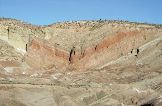
Drainage networks adjust to the underlying geology, with stream development occurring most rapidly on weaker, more permeable rocks. The resulting patterns often reflect the structural grain of the terrain:910
- Dendritic Patterns: These branching, tree-like networks form on flat-lying sedimentary rocks or uniform materials where there is no significant structural control.911
- Trellis Patterns: These develop in areas of tight, plunging folds. Trunk streams align with weak rocks along fold axes, while smaller feeder streams descend the sides of resistant ridges.911
- Rectangular and Angular Patterns: These emerge where drainage lines are constrained by intersecting faults and joints, often meeting at right angles.911
- Radial and Centripetal Patterns: Radial patterns typically form on volcanic cones or structural domes, while centripetal drainage converges toward a central outlet, such as a crater or desert depression.9
Influence of Soil and Permeability
Soil characteristics significantly impact how water is partitioned between surface runoff and subsurface flow.12
- Permeability and Runoff: Soils with high clay content often possess low permeability, which inhibits downward percolation. This forces water to flow laterally as subsurface runoff or accumulate on the surface, increasing the potential for erosion and flooding.12
- Subsurface Drainage: Soils rich in sand and silt are generally more porous, making them better suited for subsurface drainage because they transmit water more rapidly.13
- Structural Obstacles: A well-developed clay horizon (Bt) can act as a deep-seated barrier, causing water to saturate the upper soil profile and potentially triggering mass movements like landslides.12
Ultimately, while rivers may initially follow the slope of the land, they often become “superimposed” or “antecedent” as they cut through varying rock layers, creating complex features like transverse canyons that cut across existing structural trends.96
What are the different types of drainage patterns that can occur in a basin?
Drainage patterns are the distinctive arrangements that stream networks acquire as they adjust to the underlying geologic structure of a basin. These patterns reflect the resistance of rocks, the presence of faults, and the regional slope of the terrain.911
Common drainage patterns include:
- Dendritic: A branching, tree-like network that forms on flat-lying sedimentary rocks or uniform materials where structural control is minimal.911
- Trellis: A zigzag pattern resulting from adjustment to tight, plunging regional folds. Trunk streams align with weak rocks along fold axes, while feeder streams descend the sides of resistant ridges.9
- Rectangular: A pattern characterized by streams making frequent right-angle bends, typically where drainage is constrained by intersecting faults and joints.915
- Radial: A pattern where streams flow outward from a central high point, such as a volcanic cone or structural dome.911
- Centripetal: A pattern where drainage converges toward a single central outlet or sink, such as a crater or desert depression.9
- Deranged: A chaotic pattern featuring interrupted channels, lakes, and swamps, often found in areas recently shaped by continental glaciation.9
- Parallel: A pattern where trunk streams run subparallel to one another, typically occurring on surfaces with a broad regional tilt or slope.911
What role do drainage basins play in the water cycle?
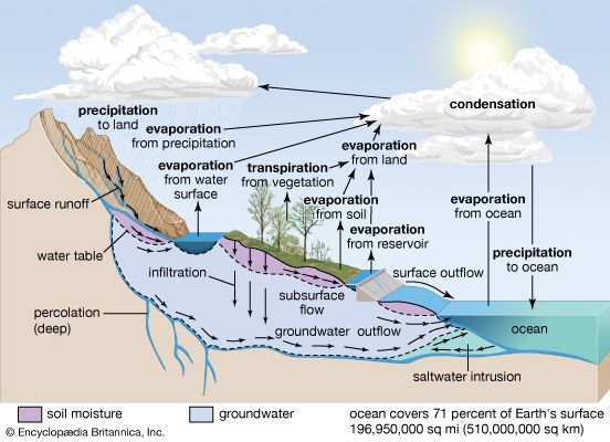
A drainage basin serves as a fundamental unit for understanding the hydrology of the water cycle. It is defined as the specific land area from which all precipitation—whether through surface runoff or subsurface flow—drains into a single stream or network of streams.4
Within this area, the drainage basin acts as a natural laboratory where scientists measure key components of the water cycle, including:
- Inputs and Outputs: Basins allow for the assessment of precipitation, evapotranspiration, and total water discharge.4
- Storage: Water is held within the basin in various forms, including groundwater tables, soil moisture, lakes, and stream channels. This storage helps regulate the timing and volume of water flow.16
- Runoff Processes: The basin facilitates the transition of rainfall into overland flow and subsurface flow. The efficiency of this process is dictated by the basin’s lithology, soil permeability, and vegetation cover.1617
By defining the boundaries of these systems via drainage divides, researchers can derive moisture and energy balances, which are essential for understanding how water moves through the landscape and shapes the earth’s surface.4
Sources
- river - Environments of deposition — Encyclopædia Britannica
- river - Drainage diversion by stream capture — Encyclopædia Britannica
- river - Effects of climatic change — Encyclopædia Britannica
- drainage basin — Encyclopædia Britannica
- hydrosphere - Impact of human activities on the hydrosphere — Encyclopædia Britannica
- river - Geomorphic variables — Encyclopædia Britannica
- dam - Construction techniques — Encyclopædia Britannica
- dam - Potential weakness — Encyclopædia Britannica
- river - Drainage patterns — Encyclopædia Britannica
- river - Formation of canyons and gorges — Encyclopædia Britannica
- valley - Drainage patterns — Encyclopædia Britannica
- soil - Water runoff — Encyclopædia Britannica
- valley - Influence of structure — Encyclopædia Britannica
- Drainage - Planning a drainage system — Encyclopædia Britannica
- rectangular drainage pattern — Merriam-Webster
- river - Determining factors — Encyclopædia Britannica
- Drainage — Encyclopædia Britannica
- valley - Runoff processes — Encyclopædia Britannica
- hydrologic sciences - Groundwater — Encyclopædia Britannica
Published on · 4 min read