Eucla Basin
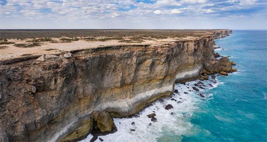
The Eucla Basin is an artesian depression located in Western Australia and South Australia, covering an area of approximately 69,500 square miles (180,000…
What is Eucla Basin?
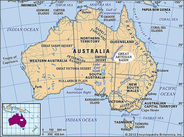
The Eucla Basin is an artesian depression located in Western Australia and South Australia, covering an area of approximately 69,500 square miles (180,000 square km). It slopes southward toward the Great Australian Bight and is approximately coincident with the Nullarbor Plain, a vast limestone region.12
The basin’s geological structure consists of two primary layers:
- Upper layer: A sequence of Neogene and Paleogene limestones (approximately 2.6 to 65 million years old).1
- Deeper layer: Sandstone of Cretaceous age (approximately 65 to 145 million years old).1
Surface water filtering through the limestone has formed extensive subterranean caves and tunnels, and limited groundwater can be accessed via bores. The name “Eucla” originates from Aboriginal words meaning “bright” and “fire”.1
What is a karst landscape and how does it form?
A karst landscape is a distinctive terrain characterized by barren, rocky ground, caves, sinkholes, and underground rivers, often with a notable absence of surface streams and lakes3. Approximately 15 percent of the Earth’s land surface is classified as karst.34
How Karst Landscapes Form
Karst topography is primarily formed through the chemical dissolution of soluble bedrock—most commonly limestone or dolomite—by circulating groundwater. The process typically involves:53
- Chemical Dissolution: Rainwater absorbs carbon dioxide from the atmosphere and soil, becoming slightly acidic. As this water percolates through cracks and joints in the rock, it dissolves the calcium carbonate and carries it away in solution.5
- Conduit Development: Over time, these cracks widen into complex underground drainage systems, including tunnels and cave networks, which facilitate the rapid movement of water underground.53
- Surface Features: As subsurface voids grow, the land surface may collapse, creating sinkholes. In some areas, surface streams may sink into these openings, leaving behind “dry valleys” where water once flowed.56
How do aquifers store and transport groundwater?
An aquifer is a subsurface rock layer that stores and transmits water in appreciable amounts. Its ability to function depends on the physical properties of the rock matrix.7
Storage
Aquifers store water within interconnected pore spaces or fractures in the rock. The capacity for storage is determined by the rock’s porosity—the volume of void space available to hold fluid. These formations are categorized based on their boundaries:78
- Unconfined aquifers: The upper surface, or water table, is open to the atmosphere through permeable material.7
- Confined aquifers: These are overlain by an impermeable rock layer, though they may still receive slow leakage from surrounding strata.7
Transport
Groundwater moves through the rock matrix when pore spaces are connected, a property known as permeability. The rate and direction of this flow are governed by pressure gradients, often described by Darcy’s law, which relates flow rate to the rock’s permeability, the cross-sectional area, and the difference in fluid heads. Groundwater is constantly in motion, typically moving toward lower pressure areas, such as streams, lakes, or the sea.78
What are some other major geological basins in Australia?
Australia features several significant geological basins that have played a crucial role in the continent’s economic and structural history. Beyond the Great Artesian Basin, which is vital for its extensive groundwater reservoirs, other major basins include:
- Cooper Basin: Located in northeastern South Australia, this basin is a major site for natural gas and oil production. It underlies the Eromanga Basin and has been a key energy source since the 1960s.1112
- Bowen Basin: Situated in central Queensland, this is one of Australia’s most important coal-producing regions. It contains rich seams of high-grade steaming and coking coals that support Australia’s position as a leading global coal exporter.1213
- Sydney Basin: Located in New South Wales, this basin is historically significant for its substantial deposits of black coal, which were deposited during the final stages of the Paleozoic Era.12
- Canning Basin: A notable Paleozoic sedimentary basin that contributes to the understanding of Australia’s structural framework.14
These basins are often characterized by their distinct sedimentary sequences, which reflect the complex tectonic and climatic history of the Australian continent.12
Sources
- Eucla Basin — Encyclopædia Britannica
- Australia - The Western Plateau — Encyclopædia Britannica
- karst — Encyclopædia Britannica
- cave — Encyclopædia Britannica
- cave - Fluviokarst — Encyclopædia Britannica
- cave - Geographic distribution of karst terrain — Encyclopædia Britannica
- aquifer — Encyclopædia Britannica
- hydrosphere - Groundwaters and river runoff — Encyclopædia Britannica
- mineral deposit - Groundwater — Encyclopædia Britannica
- hydrologic sciences - Concern over groundwater quantity and quality — Encyclopædia Britannica
- Great Artesian Basin — Encyclopædia Britannica
- Australia - Tectonic framework — Encyclopædia Britannica
- Cooper Basin — Encyclopædia Britannica
- Australia - Economic resources — Encyclopædia Britannica
- Australia - Principal regimes — Encyclopædia Britannica
- Queensland - Resources and power — Encyclopædia Britannica
Published on · 3 min read