Eyre Peninsula
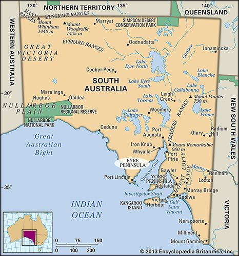
The Eyre Peninsula is a large, triangular-shaped promontory located in South Australia that projects into the Indian Ocean.
What is the geographical location and size of the Eyre Peninsula in South Australia?
The Eyre Peninsula is a large, triangular-shaped promontory located in South Australia that projects into the Indian Ocean.1
Regarding its size and geography, the peninsula features a broad-based formation measuring approximately 200 miles (320 km) on each side. It is situated between the Great Australian Bight to the west and the Spencer Gulf to the east, with its base extending along the Gawler Ranges1. The terrain is generally sandy and rocky, rising from an irregular coastline to a maximum elevation of 1,550 feet (472 m) at Nukey Bluff.1
What are some of the notable towns and cities located on the Eyre Peninsula?
The Eyre Peninsula is home to several significant towns and cities that serve as hubs for industry, agriculture, and tourism. Notable locations include:
- Whyalla: Located on the east coast, this city is a major industrial center. Originally established as a terminus for iron ore transport, it features steelworks and heavy engineering facilities. It is known for its historical role in shipbuilding and its reliance on water supplied via a long-distance pipeline from the Murray River.3
- Port Lincoln: Situated on the eastern shore, this city is a vital port and one of Australia’s largest fishing centers. It serves as the primary outlet for the peninsula’s agricultural products, including wheat, barley, and wool, and is well-known for its annual Tunarama Festival.1
- Ceduna: Positioned on the west-central coast along the Great Australian Bight, this town is a key port specializing in the fishing industry. It serves as a gateway to the Nullarbor Plain and is a significant stop on the Eyre Highway.4
- Iron Knob: Located in the northeastern part of the peninsula, this town is historically significant as the center for some of the richest iron ore deposits in the Southern Hemisphere.5
What are the major geological features of the Eyre Peninsula?
The Eyre Peninsula is a geologically stable part of the Australian continental shield, characterized by a diverse range of landforms shaped by ancient Precambrian rocks.17
Major Geological Features
- Rolling Plains and Sand Dunes: Much of the peninsula is occupied by rolling plains traversed by fixed sand dunes. These stabilized dune fields are a prominent feature of the landscape, reflecting the region’s environmental history.17
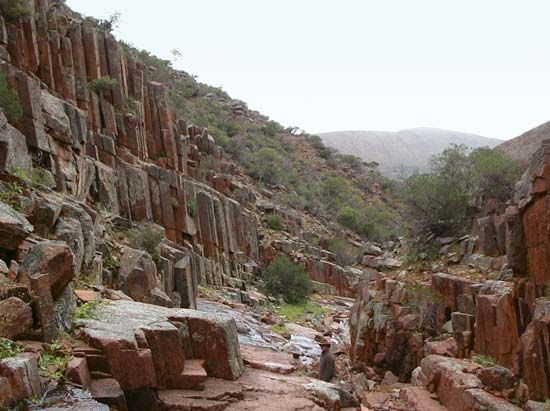
- Gawler Ranges: Located in the northern part of the peninsula, these rounded ranges are composed of Precambrian volcanic rocks that are more than 541 million years old. They reach a maximum elevation of 1,550 feet (472 m) at Nukey Bluff.128
- Inselbergs: In the northwest, the landscape is punctuated by numerous low, isolated granite rocks known as inselbergs. These spectacular formations stand prominently above the surrounding plains.1
- Laterite Deposits: Remnants of laterite—a reddish, iron-rich product of weathered rock—are found in the southern part of the peninsula, indicating that the region once experienced a humid tropical climate during the Paleogene and Neogene periods.1
- Mineral Resources: The northeastern sector, specifically the Middleback Ranges, contains significant iron ore deposits.82
How does tourism contribute to the economy of the Eyre Peninsula?
Tourism plays a significant role in the economy of the Eyre Peninsula, supported by the presence of numerous resort and fishing towns located along its extensive coastline. While the region is primarily recognized for its agricultural output—including wheat, barley, and sheep—and its industrial mining operations in the Middleback Ranges, these coastal settlements provide essential infrastructure and services that attract visitors to the area.12
The peninsula’s geography, situated between the Great Australian Bight and the Spencer Gulf, offers diverse coastal environments that underpin the local tourism industry. Additionally, historical and natural sites, such as the Gawler Ranges with their unique porphyry columns and historic reserves, contribute to the region’s appeal for travelers.12
Sources
- Eyre Peninsula — Encyclopædia Britannica
- Gawler Ranges — Encyclopædia Britannica
- Port Lincoln — Encyclopædia Britannica
- Whyalla — Encyclopædia Britannica
- Ceduna — Encyclopædia Britannica
- Iron Knob — Encyclopædia Britannica
- Australia - The Western Plateau — Encyclopædia Britannica
- Eyre Peninsula — Merriam-Webster
- South Australia - Relief — Encyclopædia Britannica
Published on · 3 min read