Grande Cascade
The Grande Cascade is a set of cataracts located in the Pyrenees mountain range near the head of the Pau Stream in southern France. Situated within the…
What is Grande Cascade?
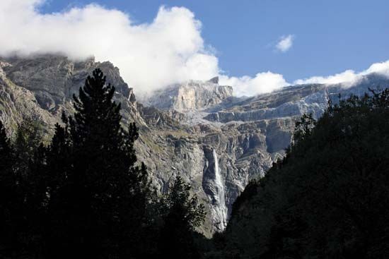
The Grande Cascade is a set of cataracts located in the Pyrenees mountain range near the head of the Pau Stream in southern France1. Situated within the Pyrénées Occidentales National Park, it reaches a height of 1,450 feet (442 meters), making it one of the highest waterfalls in the world.1
The waterfall is fed by melting snow and water from Lake Glacé in Spain. During the spring and early summer, when water volume is at its peak, its two primary falls merge into a single, powerful cascade.1
What are some other famous waterfalls in the Pyrenees?
The Pyrenees mountain range is characterized by numerous torrential rivers that descend from high peaks, often creating dramatic waterfalls as they navigate the steep, glacially eroded landscape.1
While the Grande Cascade is the most prominent waterfall in the region, it is situated within the Cirque de Gavarnie, a natural amphitheater that serves as a focal point for the area’s hydrology. The Cirque itself is renowned for its massive, precipitous rock walls that rise to approximately 5,000 feet (1,500 meters) and feature multiple terraces where snow and ice melt to feed various cascades.3
Beyond these specific features, the Pyrenees are defined by a series of parallel valleys that produce many short, high-velocity streams. While the Grande Cascade is the most famous individual waterfall in this specific sector, the entire range is dotted with smaller, unnamed cataracts formed by the rapid descent of mountain waters, particularly during the spring thaw.1
How do glaciers contribute to the formation of waterfalls?
Glaciers play a significant role in shaping landscapes and creating the conditions necessary for waterfalls through several erosional and constructional processes:
Erosional Features
- Hanging Valleys: As glaciers move, they erode main or trunk valleys much more deeply than the smaller tributary valleys that feed into them. Once the ice retreats, these tributary valleys are left “hanging” high above the main valley floor. Streams flowing from these tributaries must then drop over the steep valley walls, creating waterfalls.67
- Cirques: These bowl-shaped depressions at the head of glacial valleys are carved by the accumulation and erosive action of ice. Waterfalls frequently occur at the outlets of these cirques as water drains from the basin.6
- Glacial Steps: As ice moves over bedrock, it can create a “glacial stairway” consisting of alternating treads and risers. After the ice melts, runoff follows this path, resulting in a series of waterfalls or cascades at each riser.6
- Glacial Potholes: The plastic flow of ice can gouge semicylindrical holes into bedrock. These depressions are later deepened by meltwater runoff laden with gravel, often becoming the sites of modern cascades.6
Constructional Processes
- Moraines and Ice Dams: Glaciers can deposit ridgelike sediments known as moraines or create temporary ice dams that block drainage. These barriers can pond water, leading to the formation of waterfalls. While moraine-dammed falls are often ephemeral as the water cuts through the unconsolidated material, ice dams can cause massive outburst floods that carve deep canyons and create significant, long-lasting waterfalls.8
What are the main geographical features of the Pyrenees mountain range?
The Pyrenees is a mountain chain in southwestern Europe stretching approximately 270 miles (430 km) between the Mediterranean Sea and the Bay of Biscay. Its primary geographical features include:4
- Axial Zone: The spine of the range consists of ancient rocks, including slates, schists, limestones, and granites. This zone rises and widens from west to east, reaching its highest point at Aneto Peak (11,169 feet).411
- Pre-Pyrenean Ridges: Parallel to the axial zone are two strips of folded sedimentary rock—one French and one Spanish—which form great spurs of the main chain.1211
- Drainage Systems: The range is characterized by parallel valleys running north–south, which host short, torrential rivers. These rivers flow into broad depressions, such as the Aquitaine and Languedoc to the north and the Ebro to the south.45
- Glacial Features: Past glaciation has left behind deep valleys, cirques, and high-altitude lakes.5
- Geological Diversity: The range features hot springs, particularly in fractured axial areas, and distinct climatic zones influenced by the Atlantic Ocean and the Mediterranean.513
Sources
- Grande Cascade — Encyclopædia Britannica
- Palace of Versailles - The gardens — Encyclopædia Britannica
- Gavarnie-Gèdre — Encyclopædia Britannica
- Pyrenees — Encyclopædia Britannica
- Pyrenees - Drainage — Encyclopædia Britannica
- river - Falls attributable to discordance of river profile — Encyclopædia Britannica
- glacial landform - Hanging valleys — Encyclopædia Britannica
- river - Falls attributable to constructional processes — Encyclopædia Britannica
- glacial landform - Cirques , tarns, U-shaped valleys, arêtes, and horns — Encyclopædia Britannica
- glacier - Glacier hydrology — Encyclopædia Britannica
- Pyrenees - Physiography — Encyclopædia Britannica
- Pyrenees - Geology — Encyclopædia Britannica
- Pyrenees - Climate of Pyrenees — Encyclopædia Britannica
Published on · 3 min read