Jialing River
The Jialing River is a major river in central China and a significant tributary of the Yangtze River. It possesses the largest drainage area within the…
What is Jialing River?
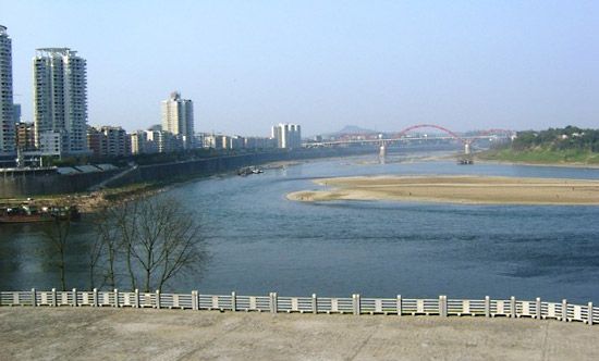
The Jialing River is a major river in central China and a significant tributary of the Yangtze River. It possesses the largest drainage area within the Yangtze basin.1
Rising in the western outliers of the Qin Mountains in southern Gansu province, the river flows through Shaanxi and cuts through the Daba Mountains. It then enters the Sichuan Basin via an extremely braided course, eventually joining the Yangtze at Chongqing after traveling approximately 740 miles (1,190 km).1
Historically and economically, the river’s upper valley serves as a vital communications artery, connecting the Wei River basin to the cities of the Sichuan Basin. Additionally, the lower course of the river is navigable by junks.1
How does the Yangtze River impact the geography of China?
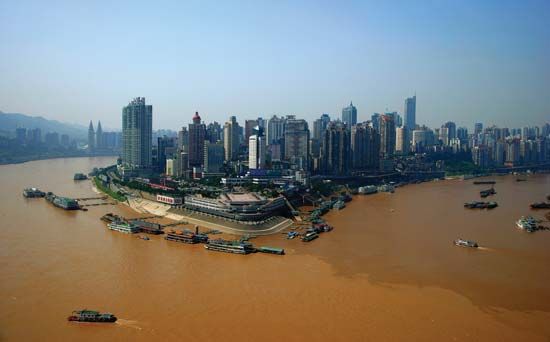
The Yangtze River is the most important river in China, profoundly shaping the nation’s geography, economy, and culture. As the longest river in Asia, its vast basin drains nearly 700,000 square miles, serving as a critical geographic backbone that traverses or borders ten provinces and regions.2
Physical and Environmental Impact
The river’s geography is defined by its diverse terrain, with over three-fourths of its course flowing through mountainous regions before reaching the extensive lowland plains of east-central China. The river system acts as a complex natural regulator; its middle course features a vast network of lakes and marshes that manage water volume, while the Yangtze delta at the East China Sea is a dynamic landscape of alluvium, sandbars, and tidal channels. Human intervention, particularly the Three Gorges Dam, has significantly altered this environment, impacting local ecosystems and forcing large-scale relocations.2345
Economic and Cultural Significance
Historically, the basin has been China’s great granary, providing the agricultural foundation for successive dynasties. The region remains the country’s most important rice-producing area and a hub for industrial centers like Wuhan and Shanghai3. Furthermore, the river has served as both a political and cultural boundary, demarcating South China and facilitating trade through infrastructure like the Grand Canal3.263
What are the major mountain ranges found in China?
China’s topography is defined by its vast and varied mountain chains, which cover approximately one-third of the country’s total area and have profoundly influenced its political, economic, and cultural development. These ranges are largely the result of the northward movement of the Indian tectonic plate, which has thrust up the towering highlands of the southwest.7
Key mountain ranges in China include:
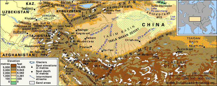
- Kunlun Mountains: A massive system in southern Central Asia that serves as a northern rampart for the Plateau of Tibet, separating it from the Tarim Basin.89
- Tien Shan: Known as the “Celestial Mountains,” this range occupies nearly one-fourth of the Xinjiang region and features peaks exceeding 24,000 feet.8
- Qin Mountains: An eastern extension of the Kunlun range that acts as a critical climatic and topographic divide between northern and southern China.10
- Daxue Mountains: Located in western Sichuan, this rugged range includes Mount Gongga, which reaches 24,790 feet.11
- Altai Mountains: Situated along the Mongolian border in the north, these mountains are characterized by rolling, dome-shaped hills.8
- Qilian Mountains: These mountains are vital to the Gansu Corridor, as their melting snow provides the water necessary for oasis farming in the region.78
How have rivers historically served as communication arteries?
Throughout history, rivers have served as the primary arteries for communication, exploration, and trade, providing the easiest and often the only means of circulation for settlers, conquerors, and merchants. By functioning as natural highways, they directed the lines of expansion and conquest in regions such as North America and northern Asia.13
Strategic Importance
- Unification and Control: Riverine cities commanded ready means of communication, allowing for the political unification of territories, such as the Nile’s role in connecting Upper and Lower Egypt. In medieval Europe, following the decline of Roman roads, rivers became essential for movement, and control over river crossing points led to the rise of strongholds and bridge towns.13
- Engineering and Connectivity: To enhance these natural routes, civilizations constructed artificial waterways. The Grand Canal in China, for example, was built to transport grain from the Yangtze and Huai valleys to northern capitals, effectively linking disparate regions. Similarly, the Romans utilized canals for military transport across Europe, including connecting the Rhine and Meuse to bypass dangerous sea passages.1415
- Modern Logistics: Today, advances in river engineering and the use of powerful towboats continue to maintain the economic viability of water transport for bulk commodities, proving that rivers remain vital infrastructure for global commerce.1617
Sources
- Jialing River — Encyclopædia Britannica
- Yangtze River — Encyclopædia Britannica
- Yangtze River - History of the Yangtze River — Encyclopædia Britannica
- Yangtze River - The Yangtze delta — Encyclopædia Britannica
- Yangtze River - The lower course — Encyclopædia Britannica
- Yangtze River - Human impact on the environment — Encyclopædia Britannica
- China - Relief of China — Encyclopædia Britannica
- Qin Mountains — Encyclopædia Britannica
- Xinjiang - Relief — Encyclopædia Britannica
- Daxue Mountains — Encyclopædia Britannica
- Kunlun Mountains — Encyclopædia Britannica
- Kunlun Mountains - Drainage and glaciation — Encyclopædia Britannica
- river - Significance in early human settlements — Encyclopædia Britannica
- Grand Canal — Encyclopædia Britannica
- river - Significance to trade , agriculture, and industry — Encyclopædia Britannica
- canals and inland waterways - Economic significance — Encyclopædia Britannica
- canals and inland waterways - Ancient works — Encyclopædia Britannica
Published on · 4 min read