Lena River
The Lena River features a diverse range of geological formations shaped by its long journey through Siberia:
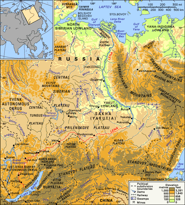
What unique geological features can be found along the Lena River’s course?
The Lena River features a diverse range of geological formations shaped by its long journey through Siberia:
- Rocky Ravines: In its upper course, the river flows through deep-cut valleys with steep, rocky slopes. A notable example is the Pyany Byk (“Drunken Bull”) ravine.
- Limestone Formations: Between Olyokminsk and Pokrovsk, the river passes through a narrow valley characterized by sheer, broken slopes. These massive limestone formations often resemble castle ruins, columns, or figures of animals and people.
- Permafrost Features: The region’s extreme cold leads to the formation of pingos and ice blisters, which are created by groundwater accumulating between layers of permafrost.
- Riverine Landscapes: The river creates extensive floodplains, particularly in the middle and lower sections, which are marked by scattered lakes, marshy terrain, and complex island-and-branch systems.
- Deltaic Structure: The river terminates in a large, rectangular delta that juts into the Laptev Sea, consisting of low-lying islands and peat bogs formed by numerous crisscrossing channels.
How do people navigate and transport goods along the Lena River?
Navigation and the transport of goods along the Lena River are dictated by the region’s harsh climate and the river’s seasonal hydrology. Because the river is only ice-free for three to six months of the year, it serves as a vital but time-limited transportation artery.12
Navigation and Transport
- Vessel Types: The river is navigable by small boats in its upper reaches below Kachug, while larger vessels operate below Ust-Kut.1
- Key Ports: Major hubs for cargo and transit include Bulun, Zhigansk, Yakutsk, Vitim, Kirensk, Osetrovo, Zhigalovo, and Kachug.1
- Cargo: The river is a primary route for moving timber, furs, gold, mica, industrial products, and food.1
- Connectivity: In the vast, remote landscape of the Sakha republic, the river acts as one of the few major transportation routes, alongside air travel and winter sled trails.2
- Arctic Integration: The river connects to the Northeast Passage (Northern Sea Route) at its delta, with the port of Tiksi serving as a significant point for regional and international shipping.3
Due to the extreme cold, the river often freezes to the bottom in winter, halting all waterborne traffic until the spring thaw.1
What are the major cities and settlements along the Lena River?
The Lena River basin is sparsely populated, with settlements primarily concentrated along the riverbanks and its tributaries. These communities often serve as vital industrial, cultural, or transportation hubs.
Major Cities and Settlements
The following locations are recognized as key ports and centers along the river’s course:
- Yakutsk: The capital of the Sakha (Yakutia) republic, this city is the most significant urban center on the Lena. Founded as a fort in 1632, it serves as a major administrative hub and river port.45
- Ust-Kut: Established in 1631, this settlement is historically significant as one of the earliest Russian outposts on the river and remains a key point for navigation.5
- Other Key Ports: Several other settlements facilitate the movement of goods and regional transit, including:
- Bulun
- Zhigansk
- Vitim
- Kirensk
- Osetrovo
- Zhigalovo
- Kachug5
While the main stem of the Lena hosts these primary ports, its tributaries also support important settlements. For instance, the Vilyuy River basin includes communities such as Vilyuysk, Verkhnevilyuysk, and Suntar, as well as industrial sites like Mirny, which became a center for diamond mining in the mid-20th century.1
What are the main tributaries of the Lena River, and how do they contribute to its flow?
The Lena River relies on a vast network of tributaries to supply its water, as more than 95 percent of its flow is derived from melting snow and rain. These tributaries significantly increase the river’s volume and width as it progresses toward the Arctic.
Major Tributaries
The river’s flow is bolstered by several large tributaries, categorized by the bank on which they join the main stem:
- Right Bank: The Vitim River, Olyokma River, Aldan River, and the Great Chuya River.
- Left Bank: The Vilyuy River, Kirenga River, and Nyuya River.
Contribution to Flow
The tributaries are essential to the river’s hydrology in several ways:
- Volume Increase: The river becomes a large, deep waterway particularly after its junction with the Olyokma. The water supply increases substantially following the confluence with major tributaries like the Vitim and Aldan.
- Seasonal Hydrology: Because the Lena basin experiences high summer floods and very little winter flow, these tributaries act as the primary conduits for the massive influx of water during the spring thaw and summer rains.
- Navigation: Several of these tributaries, including the Kirenga, Vilyuy, Vitim, Olyokma, and Aldan, are considered major navigable routes that support regional transport and economic activity.
Sources
- Lena River — Encyclopædia Britannica
- Sakha — Encyclopædia Britannica
- Northeast Passage — Encyclopædia Britannica
- Vilyuy River — Encyclopædia Britannica
- Yakutsk — Encyclopædia Britannica
Published on · 4 min read