Loess Plateau
The Loess Plateau is a highland region located in north-central China. It encompasses a significant portion of Shanxi, Shaanxi, and Gansu provinces, as well…
What is the geographical location and extent of the Loess Plateau in China?
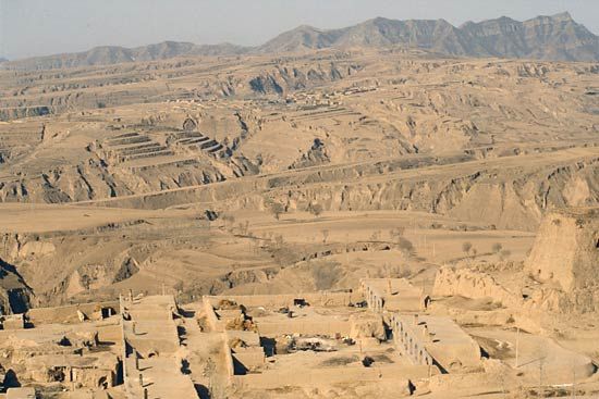
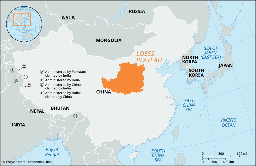
The Loess Plateau is a highland region located in north-central China. It encompasses a significant portion of Shanxi, Shaanxi, and Gansu provinces, as well as northern Henan, and is situated within the middle basin of the Huang He (Yellow River).1
As the world’s largest loess plateau, it covers approximately 154,000 square miles (400,000 square km) and maintains an average elevation of about 4,000 feet (1,200 meters). The area is characterized by a thick mantle of wind-deposited, yellowish alluvium that typically ranges from 165 to 260 feet (50 to 80 meters) in depth, masking the underlying terrain. Due to its susceptibility to erosion, the region has been the focus of extensive government-led conservation efforts, including terracing and afforestation, to support agricultural productivity.1
How does the climate of the Loess Plateau affect agriculture in the region?
The climate of the Loess Plateau significantly shapes agricultural practices, primarily by dictating water availability and the length of the growing season. As one moves north and west across the plateau, the climate becomes progressively colder and drier, with some areas receiving as little as 10 inches (250 mm) of annual precipitation.1
Because most rainfall occurs in late summer and autumn—often when evaporation rates are at their peak—agriculture in the region is frequently challenged by water scarcity. Farmers must employ specialized techniques to minimize evaporation and conserve soil moisture to sustain crops. Furthermore, the region is prone to severe and prolonged droughts, which can make agricultural conditions precarious, particularly near the northern frontier.1
The plateau’s vulnerability to soil erosion is also climate-driven; heavy summer rains, combined with sparse vegetation, wash away topsoil and carve deep gullies into the landscape. To mitigate these effects and improve land productivity, the government has implemented extensive programs for afforestation and terracing, which help stabilize the soil and retain water for grain production.23
What are some of the major rivers that originate from or flow through the Loess Plateau?
The Loess Plateau is defined by its complex drainage system, dominated by the Huang He (Yellow River) and its major tributaries. Because the plateau consists of loose, wind-deposited soil, these rivers have carved deep valleys and gorges, carrying massive quantities of silt downstream.16
Major Rivers of the Loess Plateau
- Huang He (Yellow River): The most significant river in the region, the middle course of the Yellow River flows directly through the Loess Plateau. It forms the border between Shaanxi and Shanxi provinces, cutting through narrow, steep-sided gorges.167
- Wei River: As the longest tributary of the Yellow River, the Wei River flows through the southern portion of the plateau in Gansu and Shaanxi provinces. Its basin is heavily dissected by the loess landscape, and it has historically been a vital center for irrigation and agriculture.8
- Fen River: The Fen River is another major tributary of the Yellow River. It flows through a series of loess-filled basins in Shanxi province, creating a chain of valleys that cross the plateau from the northeast to the southwest.67
- Jing and Luo Rivers: These are significant tributaries of the Wei River located in Shaanxi province, further contributing to the drainage network of the plateau’s heavily eroded terrain.8
How does the Loess Plateau compare to other loess deposits found around the world?
The Loess Plateau in China is distinguished as the world’s largest loess-covered region, covering approximately 154,000 square miles (400,000 square km). While loess deposits are found across Asia, Europe, and North America, the Chinese plateau is unique in both its scale and the extreme thickness of its deposits, which average 165–260 feet (50–80 meters).14
Key comparisons include:
- Elevation and Relief: While loess typically occurs on plains or river valley slopes, the Loess Plateau reaches elevations up to 4,000 meters, significantly higher than the 400–600 meter maximums often seen in European deposits.5
- Structural Integrity: The plateau is famous for its ability to retain vertical or overhanging walls, with some bluffs standing 150 meters high. This structural property is so pronounced that local inhabitants have historically excavated cellarlike dwellings directly into the loess.4
- Formation Processes: Loess worldwide is generally formed by wind-deposited silt, but the specific source of that dust varies. In North America and Europe, much of the loess is associated with glacial activity (the “glacial loess” theory), whereas the Loess Plateau’s deposits are largely linked to continental desert sources in Inner Asia.510
- Agricultural Utility: Globally, loess is prized for its fertile soil, which is highly conducive to intensive agriculture. However, the Loess Plateau faces unique challenges due to its sparse vegetation and heavy summer rains, which necessitate extensive terracing and afforestation to combat severe erosion.41
Sources
- Loess Plateau — Encyclopædia Britannica
- Shaanxi - Climate of the Shaanxi — Encyclopædia Britannica
- China - Soils of China — Encyclopædia Britannica
- loess — Encyclopædia Britannica
- loess - Distribution and classification. — Encyclopædia Britannica
- Yellow River - The middle course — Encyclopædia Britannica
- Yellow River - Hydrology of the Yellow River — Encyclopædia Britannica
- Wei River — Encyclopædia Britannica
- Shanxi - Relief — Encyclopædia Britannica
- loess - Origin and age. — Encyclopædia Britannica
Published on · 4 min read