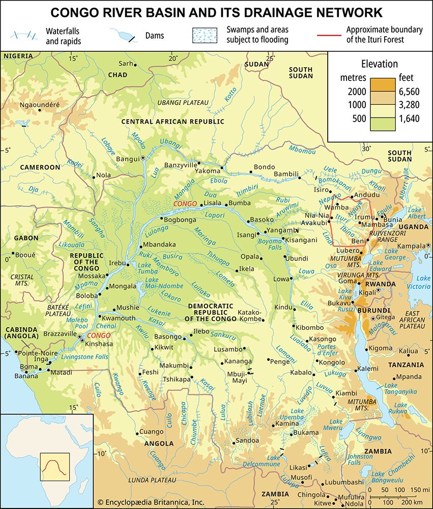
Lualaba River
The Lualaba River is the primary headstream of the Congo River and serves as a vital component of the Democratic Republic of the Congo’s geography and…
How has the Lualaba River influenced the history and development of the Democratic Republic of Congo?
The Lualaba River is the primary headstream of the Congo River and serves as a vital component of the Democratic Republic of the Congo’s geography and economy. By carrying the greatest volume of water, it functions as the river’s true main stream.12
Its influence on development is primarily defined by two factors:
- Hydroelectric Power: The river’s significant descent from the Katanga plateau is harnessed for energy production, such as at the Nzilo Dam. Similarly, its tributaries, like the Luvua River and Lufira River, provide essential power for the nation’s critical mining and smelting industries in the copper-rich Katanga region.134
- Transportation and Infrastructure: While the Lualaba is navigable in certain stretches, its course is frequently interrupted by rapids and gorges, necessitating a mix of river and rail transport to move minerals like copper to the coast. The river also acts as a physical barrier to land travel, requiring the construction of strategic bridges, such as the one at Kongolo, to connect inland regions.15
How do local communities utilize the Lualaba River for transportation and economic activities?
Local communities utilize the Lualaba River as a vital artery for transportation and economic activity, though its utility is dictated by the river’s varied geography.
Transportation
The river serves as a crucial navigational link in regions where road infrastructure is limited or nonexistent. It is navigable for a 400-mile stretch through the Kamolondo Trough, as well as shorter segments between Kasongo and Kibombo, and again toward Boyoma Falls. Because the river is frequently interrupted by rapids and gorges—such as the impassable Portes d’Enfer—communities often rely on a combination of river and rail transport to move goods. Strategic infrastructure, such as the rail-and-road bridge at Kongolo, is essential for connecting these inland areas.15
Economic Activities
- Energy Production: The river’s descent is harnessed for hydroelectric power, notably at the Nzilo Dam. This energy is critical for supporting the nation’s mining and smelting industries.163
- Resource Management: In the marshy lakes of the Kamolondo Trough, the river environment supports local ecosystems that are periodically flooded. Additionally, the river system facilitates the transport of agricultural produce and minerals, which remain essential for regional economic development.15
Are there any significant hydroelectric projects or dams along the Lualaba River?
Yes, there are several significant hydroelectric projects and dams associated with the Lualaba River and its major tributaries, which are essential for powering the region’s mining and smelting industries.51
Key hydroelectric developments include:
- Nzilo Dam: Located on the Lualaba River near the Nzilo Falls (formerly Delcommune Falls), this dam harnesses the river’s steep descent from the Katanga plateau to generate hydroelectric power.1
- Lufira River Dam: The Lufira River, a tributary of the Lualaba, was dammed near Likasi to create a large reservoir. This facility provides critical power for the smelting industry in Likasi and the copper-mining zone between Kambove and Lubumbashi.5
- Piana Mwanga: Located on the Luvua River, another Lualaba tributary, the falls at Piana Mwanga have been harnessed to supply electricity to the mines at Manono and Kitotolo.7
These projects are vital to the Democratic Republic of the Congo, as the country relies heavily on its vast hydroelectric resources to support industrial development across its mineral-rich regions.3
What is the geographical location and course of the Lualaba River?
The Lualaba River is the headstream of the Congo River and lies entirely within the Democratic Republic of the Congo. Spanning 1,100 miles (1,800 km), it originates on the Katanga (Shaba) plateau near Musofi at an elevation of approximately 4,600 feet (1,400 m).1
The river’s course is characterized by significant topographical shifts:
- Upper Course: It descends to the Manika Plateau, featuring numerous falls and rapids. A steep drop into the Kamolondo Trough is utilized for hydroelectric power generation at the Nzilo Dam.1
- Navigable Sections: Within the Kamolondo Trough, the river becomes navigable for 400 miles (644 km), expanding into marshy lakes such as Upemba and Kisale. Further downstream, navigation is intermittent due to gorges like the Portes d’Enfer and various rapids, though sections between Kasongo and Kibombo, and toward Boyoma Falls, remain navigable.1
- Termination: The river’s course concludes at the seven cataracts of Boyoma Falls, where it officially becomes the Congo River.1
While the Chambeshi River is considered the Congo’s longest source, the Lualaba carries the greatest water volume.4
Sources
- Lualaba River — Encyclopædia Britannica
- Lualaba — Merriam-Webster
- Luvua River — Encyclopædia Britannica
- Congo River — Encyclopædia Britannica
- Lufira River — Encyclopædia Britannica
- Congo River - Transportation — Encyclopædia Britannica
- Copperbelt — Encyclopædia Britannica
- Democratic Republic of the Congo - Resources and power — Encyclopædia Britannica
Published on · 3 min read