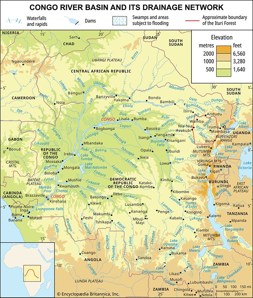
Luvua River
The Luvua River is a tributary of the Lualaba River located in southeastern Congo (Kinshasa). It originates at the northern end of Lake Mweru, situated on…
What is Luvua River?
The Luvua River is a tributary of the Lualaba River located in southeastern Congo (Kinshasa). It originates at the northern end of Lake Mweru, situated on the border between Congo and Zambia, and flows approximately 220 miles (350 km) northwest.1
The river passes by the town of Kiambi, after which its lower 100-mile (160 km) stretch is navigable by shallow-draft boats. Its middle course is characterized by rapids, and at Piana Mwanga, the river’s falls are utilized to generate electricity for the mines at Manono and Kitotolo. As a tributary of the Lualaba, the Luvua contributes to the broader river system that eventually forms the Congo River.12
What is the relationship between the Luvua and the Congo River?
The Luvua River serves as a significant tributary within the vast Congo River system. Its relationship to the Congo is defined by its role as a feeder stream for the Lualaba River, which acts as the primary headstream of the Congo River proper.12
The connection functions as follows:
- Hydrological Link: The Luvua originates at the northern end of Lake Mweru and flows northwest to join the Lualaba River opposite the town of Ankoro.1
- System Integration: The Lualaba River, which receives the waters of the Luvua, flows northward until it reaches Boyoma Falls. These cataracts mark the transition where the Lualaba ends and the Congo River begins.2
- Basin Context: As part of the broader Congo basin, the Luvua is integrated into a complex, fan-shaped network of tributaries that sustain the flow of the main river channel as it traverses central Africa toward the Atlantic Ocean.3
How is hydroelectric power generated from rivers like the Luvua?
Hydroelectric power is generated by converting the potential energy of falling or fast-flowing water into mechanical energy and then into electricity.4
In the case of the Luvua River, this process is harnessed at Piana Mwanga, where the river’s natural falls are utilized to provide power for local mining operations. The general mechanism for such generation typically involves the following components:5
- Water Collection: Water is collected or stored at a higher elevation, often using a dam to create a significant difference in elevation known as the head.4
- Conveyance: The water is directed downward through large pipes or tunnels, called penstocks, toward a lower elevation.4
- Turbines and Generators: As the water exits the penstocks, its force causes turbines to rotate. These turbines are connected to generators, which convert the mechanical rotation into electrical energy.4
- Transmission: Transformers then adjust the voltage of the generated electricity to a level suitable for long-distance transmission.4
While this process provides a renewable energy source, it can also lead to environmental challenges, such as the disruption of fish migration and the displacement of human or ecological communities due to reservoir creation.64
What are the unique characteristics of Lake Mweru?
Lake Mweru is a significant body of water located in central Africa, straddling the border between Zambia and the Democratic Republic of the Congo. Its name is derived from a Bantu word simply meaning “lake.”8
Key characteristics of the lake include:
- Geography and Dimensions: Situated approximately 3,010 feet (917 m) above sea level, the lake spans about 1,900 square miles (4,920 square km). It stretches 76 miles (122 km) in length with an average width of 31 miles (50 km).8
- Topography: The lake’s margins are predominantly flat, with the notable exception of its rocky western coastline. It contains two islands in its southern region: Kilwa and Sokwe.8
- Hydrological Role: As part of the Congo River system, it acts as a major link in the regional watershed. The Luapula River feeds into the lake from the south, while the Luvua River exits from the north near the town of Pweto.81
- Surroundings: The area is characterized by the extensive Bangweulu Swamps, which adjoin the lake to the east and south.8
Sources
- Luvua River — Encyclopædia Britannica
- Lualaba River — Encyclopædia Britannica
- Congo River - Physiography — Encyclopædia Britannica
- dam - Rise of environmental and economic concerns — Encyclopædia Britannica
- Did you know? — Merriam-Webster
- hydroelectric power — Encyclopædia Britannica
- waterfall — Encyclopædia Britannica
- Lake Mweru — Encyclopædia Britannica
- Mweru — Merriam-Webster
Published on · 3 min read