Maiko National Park
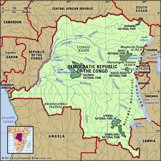
Maiko National Park is a 4,180-square-mile (10,830-square-kilometre) reserve located in the eastern Democratic Republic of the Congo. Situated between the…
What is Maiko National Park?
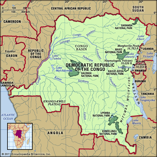
Maiko National Park is a 4,180-square-mile (10,830-square-kilometre) reserve located in the eastern Democratic Republic of the Congo. Situated between the Western Rift Valley and the Congo River, the park is characterized by dense equatorial forest.1
The reserve serves as a critical habitat for various wildlife, including elephants, leopards, gorillas, and the okapi, a forest-dwelling relative of the giraffe. Despite its ecological significance, the park has not been developed for tourism. Conservation efforts have been severely hampered by civil strife that began in the late 1990s and has persisted into the 21st century, leading to threats such as poaching and habitat destruction.12
What is an okapi and why is it unique?
The okapi (Okapia johnstoni) is a cud-chewing mammal belonging to the family Giraffidae, making it the only living relative of the giraffe. Found in the rainforests of the Democratic Republic of the Congo, this elusive species serves as a flagship for the Ituri Forest.3
The okapi is unique for several reasons:
- Distinctive Appearance: Despite its relation to the giraffe, it has a much shorter neck and legs. Its coat is deep brown, almost purple, while its buttocks and legs feature striking horizontal black-and-white stripes, resembling a zebra.34
- Physical Adaptations: It possesses a long, prehensile tongue used to strip leaves from branches. Males have short, skin-covered horns.3
- Elusive History: The species remained unknown to Western science until 1901, despite reports from explorers in the late 19th century.3
- Conservation Status: Listed as an endangered species, the okapi is threatened by habitat loss and hunting.3
We could dive deeper into the specific conservation challenges facing the Ituri Forest or compare the evolutionary traits of the Giraffidae family.
How does the Western Rift Valley influence the geography of the Congo?
The Western Rift Valley, which forms the eastern border of the Democratic Republic of the Congo, is a primary influence on the nation’s geography and topography. Its formation has significantly shaped the region in the following ways:5
- Topographical Elevation: The rift zone is the highest and most rugged part of the country, characterized by striking mountain chains. This includes the Mitumba Mountains, which rise to 9,800 feet, and the Ruwenzori Range, which contains Margherita Peak, the country’s highest point at 16,763 feet.56
- Tectonic Influence on the Basin: The formation of the rift has contributed to the uplifting of the eastern edge of the central Congo basin, contrasting with the basin’s persistent tendency toward subsidence.78
- Hydrological Features: The valley contains a series of major lakes, including Albert, Edward, Kivu, and Tanganyika. These lakes and their associated rivers, such as the Lukuga River, create complex drainage connections that link the rift system to the broader Congo River network.5910
- Volcanic Activity: The Virunga Mountains, a chain of volcanoes stretching across the rift, act as a divide between the Nile and Congo river drainage systems.1110
What are the main challenges to wildlife conservation in the Democratic Republic of the Congo?
Wildlife conservation in the Democratic Republic of the Congo faces severe challenges that threaten the nation’s rich biodiversity. The primary obstacles include:
- Civil Strife and Warfare: Long-standing conflict and political instability, beginning in the late 1990s and continuing into the 21st century, have severely disrupted conservation efforts. This instability has led to the murder of park rangers, the kidnapping of tourists, and the general inability to enforce protection within national parks.1213
- Poaching: Illegal hunting for commercial profit and subsistence remains a major existential threat. Species such as elephants, gorillas, and okapi are frequently targeted, leading to critical population declines.21413
- Human Encroachment and Deforestation: The growth of permanent settlements within protected areas and the influx of refugees fleeing regional conflicts have led to widespread deforestation. This habitat destruction, combined with agricultural expansion, has disrupted natural animal migration patterns and reduced available living space for wildlife.1513
Sources
- Maiko National Park — Encyclopædia Britannica
- Ituri Forest - Plant and animal life — Encyclopædia Britannica
- okapi — Encyclopædia Britannica
- okapi — Merriam-Webster
- Democratic Republic of the Congo - Relief — Encyclopædia Britannica
- Congo River - Physiography — Encyclopædia Britannica
- Democratic Republic of the Congo - Drainage and soils — Encyclopædia Britannica
- Congo basin — Encyclopædia Britannica
- tectonic basins and rift valleys - Rift valleys — Encyclopædia Britannica
- Semliki River — Encyclopædia Britannica
- East African mountains - Geology — Encyclopædia Britannica
- East African lakes - Physiography — Encyclopædia Britannica
- list of World Heritage sites - Democratic Republic of the Congo — Encyclopædia Britannica
- Africa - Conservation of Africa — Encyclopædia Britannica
- poaching — Encyclopædia Britannica
- Virunga National Park — Encyclopædia Britannica
- Democratic Republic of the Congo - Plant and animal life — Encyclopædia Britannica
Published on · 3 min read