Mentawai Islands
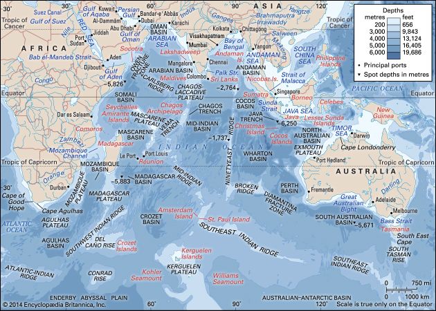
The Mentawai Islands are an archipelago of approximately 70 islands situated in the Indian Ocean, located off the western coast of Sumatra, Indonesia.
Where are the Mentawai Islands located, and what is their geographical significance?
The Mentawai Islands are an archipelago of approximately 70 islands situated in the Indian Ocean, located off the western coast of Sumatra, Indonesia.1
The islands hold significant geographical and geological importance:
- Topography and Hazards: The archipelago is characterized by steep, rocky western coasts and frequent earthquakes. The region’s tectonic activity is notable; for instance, a 7.7-magnitude earthquake in 2010 triggered a tsunami that caused significant devastation to coastal communities.1
- Environment: Most of the islands are covered in dense forest, with Siberut Island—the largest of the group—featuring a warm, humid climate, mangrove swamps, and low-lying marshy coastlines.12
- Accessibility: The islands are separated from the Sumatran mainland by the Mentawai Strait. Navigation is challenging due to heavy surf and surrounding coral reefs, which make maritime approaches dangerous.12
What role do the Mentawai Islands play in Indonesia’s economy and national identity?
The Mentawai Islands contribute to the local economy primarily through agriculture and small-scale production, though they play a limited role in the broader national economy of Indonesia.21
Economic Contributions
The islands’ economy is largely subsistence-based and localized. Key economic activities include:
- Agriculture: Residents cultivate crops such as sago, sugar, tobacco, cassava, sweet potatoes, and various fruits. Taro and yams are also staple crops.21
- Exports: Copra (dried coconut meat) serves as the primary export for the archipelago.1
- Cottage Industries: Local production includes basketry, weaving, and wood carving.2
- Fishing and Gathering: Deep-sea fishing and the gathering of forest products supplement the agricultural output.21
National Identity
Regarding national identity, the Mentawai Islands are recognized as part of the West Sumatra (Sumatera Barat) province. The indigenous Mentawai people are noted for their distinct cultural heritage, including traditional social structures based on patrilineal clan groups and unique architectural styles, such as houses built on stilts along riverbanks.21
How do the Mentawai Islands compare to other Indonesian island chains in terms of development and infrastructure?
Compared to more developed or densely populated regions of Indonesia, the Mentawai Islands remain characterized by limited infrastructure and a largely subsistence-based economy.21
While major Indonesian hubs benefit from extensive transportation networks and urban integration, the Mentawai archipelago faces significant geographical and logistical barriers:
- Transportation: There are very few roads across the islands. While the principal settlement of Muarasiberut is linked by road to locations like Sigep, Simansih, and Taileleo, connectivity remains highly localized.12
- Maritime Access: Access to the islands is difficult due to steep, rocky western coasts, dangerous coral reefs, and heavy surf. Communication and trade with the mainland rely on the port of Telukbayur near Padang, Sumatra, which serves as a vital link across the Mentawai Strait.12
- Developmental Constraints: The region’s development is frequently interrupted by natural hazards, such as frequent earthquakes and tsunamis, which have historically caused significant displacement and destruction of infrastructure.21
In contrast to the rapid modernization seen in other parts of the country, the Mentawai Islands maintain a traditional focus on agriculture, fishing, and cottage industries.21
How do earthquakes and tsunamis shape the geology of the Mentawai Islands?
The Mentawai Islands are located in a highly active seismic zone off the western coast of Sumatra, which frequently subjects the archipelago to earthquakes and tsunamis.1
While these events are primarily recognized for their devastating impact on human settlements and infrastructure—such as the 2010 magnitude 7.7 earthquake that triggered a 10-foot tsunami—they are also a consequence of the region’s dynamic geological setting. The islands’ western coasts are characterized by steep, rocky terrain, and the surrounding waters are marked by dangerous coral reefs, features often associated with the tectonic activity of the Indian Ocean floor.1
The persistent seismic activity serves as a constant environmental force, shaping the coastal landscape and influencing the vulnerability of the islands’ low-lying areas. Because the islands are generally low in elevation, rarely exceeding 1,500 feet (450 meters), they remain particularly susceptible to the physical changes and destruction wrought by these powerful geological events.12
Sources
- Mentawai Islands — Encyclopædia Britannica
- Siberut Island — Encyclopædia Britannica
Published on · 3 min read