Moray Firth
The Moray Firth is a triangular-shaped inlet of the North Sea located in northeastern Scotland. It spans a maximum width of 16 miles (29 km) between Tarbat…
What is Moray Firth?
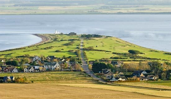
The Moray Firth is a triangular-shaped inlet of the North Sea located in northeastern Scotland. It spans a maximum width of 16 miles (29 km) between Tarbat Ness to the north and Burghead to the south.1
The inlet features two smaller extensions, the Cromarty Firth and the Beauly Firth, which reach further inland. The city of Inverness is situated at the head of the firth, while the southern shore is bordered by the town of Nairn and the Moray council area. The coastal landscape of the region is characterized by beaches and sand dunes, with rivers such as the River Spey and the Findhorn flowing across fertile plains to empty into the firth.12
What kind of marine life lives in the Moray Firth?
How did the Picts influence the history of this region?
The Picts played a foundational role in the history of northeastern Scotland, including the region surrounding the Moray Firth. Occupying these lands until the 9th century, the Picts established a distinct culture characterized by their unique carved memorial stones and defensive structures, such as the round stone towers known as brochs.34
The Picts were a significant political force, notably checking the northward expansion of the Angles at the Battle of Nechtansmere in 685. By the 7th century, they had formed a united “Pict-land,” which was eventually integrated into the broader Scottish state. In 843, Kenneth I (Kenneth MacAlpin) united the Picts with the Scots, creating the kingdom of Alba. Following this union, the Pictish lands became known as Moray, which served as one of the seven traditional provinces of ancient Scotland and produced notable monarchs such as Macbeth.435
What role does the North Sea play in Scotland’s economy?
The North Sea has been a cornerstone of Scotland’s economy since the 1970s, primarily through the development of petroleum and natural gas reserves located beneath the seafloor.89
Energy and Industry
- Petroleum and Gas: Although the British government retains ownership of the resources, the extraction industry has created tens of thousands of jobs in Scotland, ranging from platform construction to operational servicing. Aberdeen serves as the primary hub for this industry, and the economy of the Shetland Islands has also seen significant benefits.8
- Infrastructure: Increased traffic from oil production necessitated upgrades to the Scottish road and bridge network, including spans over the Cromarty and Moray firths.10
- Renewables: Scotland has leveraged its maritime position to become a global leader in the development of deep-sea offshore wind farms and research into wave and tidal energy.8
Fishing
The North Sea remains one of Europe’s most productive fisheries. The seafood industry is vital to the Scottish economy, with Scottish ports handling approximately two-thirds of the total British fish and shellfish catch.911
Sources
- Moray Firth — Encyclopædia Britannica
- Moray — Encyclopædia Britannica
- Pict — Encyclopædia Britannica
- Scotland - The unification of the kingdom — Encyclopædia Britannica
- Pictish language — Encyclopædia Britannica
- Pict — Merriam-Webster
- Scotland - Roman penetration — Encyclopædia Britannica
- Scotland - Resources and power — Encyclopædia Britannica
- Scotland - Fishing — Encyclopædia Britannica
- Scotland - Economy of Scotland — Encyclopædia Britannica
- Scotland - Transportation — Encyclopædia Britannica
- North Sea — Encyclopædia Britannica
Published on · 2 min read