Mount Jacques Cartier
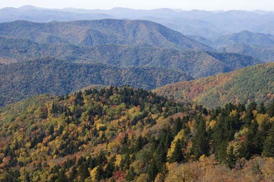
Mount Jacques Cartier is a mountain located on the Gaspé Peninsula within Gaspesian Provincial Park in eastern Quebec, Canada.
What is Mount Jacques Cartier?
Mount Jacques Cartier is a mountain located on the Gaspé Peninsula within Gaspesian Provincial Park in eastern Quebec, Canada.12
Standing at an elevation of 4,160 feet (1,268 meters), it serves as the highest peak of the Monts Chic-Choc (Shickshock Mountains), which are an extension of the Appalachian Mountains. The mountain is also known for its flat summit, which is reflected in the name “Tabletop”.12
What are the Chic-Choc Mountains?
The Chic-Choc Mountains (also known as the Monts Chic-Choc or Shickshock Mountains) are a prominent mountain range located in eastern Quebec, Canada. They serve as an extension of the Notre Dame Mountains and form the rugged backbone of the Gaspé Peninsula.34
Key features of the range include:
- Geological Context: They are an outcrop of the northern Appalachian Mountains.34
- Geography: The range follows the south shore of the St. Lawrence River for approximately 100 miles (160 km).3
- Elevation: The mountains reach their maximum height of 4,160 feet (1,268 meters) at Mount Jacques Cartier, which is situated within Gaspesian Provincial Park.34
Why is Gaspesian Provincial Park important for caribou?
Gaspesian Provincial Park was established in 1937 specifically to protect the fast-diminishing herds of caribou native to the region. By providing a protected habitat within the Gaspé Peninsula, the park serves as a vital sanctuary for these animals, helping to ensure their survival against the threats that had previously caused their populations to decline.2
We could dive deeper into the unique alpine environment of the park or explore other conservation efforts in Quebec.
How do the Appalachian Mountains extend into Canada?
The Appalachian Mountains extend into Canada as a vast highland system that reaches from the United States border to the island of Newfoundland. This region, known as the Appalachian region of Canada, consists of ancient folded rock formations that have been eroded into mountains, plateaus, and valleys.673
The range enters Canada through the eastern townships of Quebec, south of the St. Lawrence River valley, and continues northeastward. Key segments include:3
- Quebec: The Notre Dame Mountains and their extension, the Chic-Choc Mountains, form the rugged backbone of the Gaspé Peninsula.85
- Maritime Provinces: The highlands continue through New Brunswick and Nova Scotia as dissected plateaus.3
- Newfoundland: The system terminates in Newfoundland, where the Long Range Mountains rise along the west coast.3
This northern portion of the Appalachian orogenic belt was shaped by complex tectonic collisions over hundreds of millions of years.7
Sources
- Mount Jacques Cartier — Encyclopædia Britannica
- Gaspesian Provincial Park — Encyclopædia Britannica
- Notre Dame Mountains — Encyclopædia Britannica
- Argentina - The Gran Chaco — Encyclopædia Britannica
- Gaspé Peninsula — Encyclopædia Britannica
- Canada - The Appalachian region — Encyclopædia Britannica
- Appalachian Mountains — Encyclopædia Britannica
- Avalonian orogeny — Encyclopædia Britannica
- Appalachian orogenic belt — Encyclopædia Britannica
Published on · 2 min read