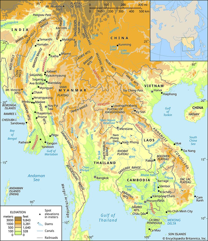
Nmai Hka
The Nmai Hka is a river located in northern Myanmar (Burma). Stretching approximately 300 miles (480 km) in length, it originates in the Languela glacier…
What is Nmai Hka?
The Nmai Hka is a river located in northern Myanmar (Burma). Stretching approximately 300 miles (480 km) in length, it originates in the Languela glacier near the border with Tibet.12
The river flows in a generally southward direction and serves as the eastern branch of the Irrawaddy River. It eventually joins the Mali River to form the main stem of the Irrawaddy1. Although the Nmai Hka carries a greater volume of water than the Mali, it is considered virtually unnavigable due to its strong current.12
How does the Mali River differ from the Nmai Hka?
The Mali and Nmai Hka rivers are the two primary branches that converge to form the Irrawaddy River in northern Myanmar. While they share a common origin in the glaciers of the remote northern mountains, they differ significantly in their physical characteristics:
- Branch Orientation: The Nmai Hka serves as the eastern branch, while the Mali River serves as the western branch.1
- Water Volume: The Nmai Hka carries a greater volume of water than the Mali River.1
- Navigability: The Nmai Hka is considered virtually unnavigable due to its strong current. In contrast, the Mali River has a gentler gradient and, despite being interrupted by rapids, contains sections that are partially navigable.213
- Length: The Nmai Hka is approximately 300 miles (480 km) long, whereas the Mali River is shorter, measuring about 200 miles (320 km) in length.23
What is the significance of the Irrawaddy River to Myanmar?
The Irrawaddy River is the principal waterway of Myanmar, serving as the country’s historical, cultural, and economic heartland. Running 1,350 miles through the center of the nation, the river has shaped settlement patterns and development for centuries.45
Economic Significance
- Transportation: It is Myanmar’s most important commercial waterway. Despite the growth of rail and road networks, the river remains vital for moving passengers and goods, including petroleum, cotton, and foodstuffs.42
- Agriculture: The river’s delta is one of the world’s major rice-growing regions, providing fertile alluvium that supports continuous cultivation. Irrigation projects, such as those in the Mu River valley, have supported dry-season crops since the 9th century.627
- Trade: The river has historically facilitated trade routes between India and China and remains a key artery for exporting commodities like teak and rice.25
Historical Significance The river served as the primary axis for the old Myanmar kingdom, enabling the Burmese to expand their power and establish flourishing civilizations, such as at Pagan.5
How are river deltas formed by sediment?
A delta is a depositional landform created when a river enters a body of standing water, such as an ocean or lake, and deposits its sediment load faster than marine processes can remove it. The formation process is a dynamic interaction between the river’s sediment supply and the energy of the receiving water body.89
The Process of Formation
As a river flows toward its mouth, its velocity—and thus its ability to transport material—gradually decreases. Upon reaching the standing water, the river’s current slows significantly, causing it to lose its transporting power. This results in the deposition of sediment, which builds up over time to form the delta.10118
The sediment is organized into a specific stratigraphic sequence:9
- Topset beds: Horizontal layers deposited on the subaerial delta plain.9
- Foreset beds: Inclined layers that accumulate at the delta front, where coarser materials settle first.9
- Bottomset beds: Fine-grained clays that are carried beyond the delta front and deposited in deeper water.9
The shape and growth of a delta depend on factors like the volume of sediment, river discharge, tidal range, and wave energy. Over time, these systems are highly dynamic; as a delta lobe extends seaward, the river may eventually shift its course to a shorter, more efficient path, abandoning the old lobe to erosion while initiating a new one elsewhere.81112
Sources
- Nmai Hka — Encyclopædia Britannica
- Irrawaddy River - Physiography — Encyclopædia Britannica
- Mali River — Encyclopædia Britannica
- Irrawaddy River — Encyclopædia Britannica
- Irrawaddy River - Irrigation — Encyclopædia Britannica
- Irrawaddy River - Navigation — Encyclopædia Britannica
- Irrawaddy River - History — Encyclopædia Britannica
- river - Deltas — Encyclopædia Britannica
- fluvial process — Encyclopædia Britannica
- river - Deposits and stratigraphy — Encyclopædia Britannica
- river - Morphology of deltas — Encyclopædia Britannica
- river - Deltas and time — Encyclopædia Britannica
- river - Environments of deposition — Encyclopædia Britannica
- river - Sedimentation in estuaries — Encyclopædia Britannica
Published on · 3 min read