Mali River
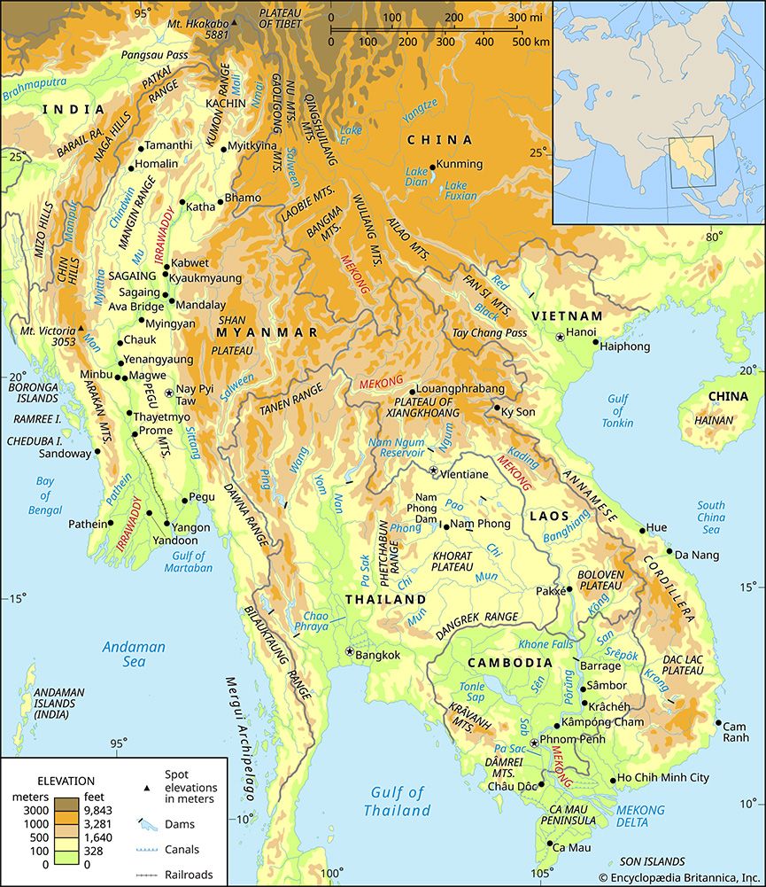
The Mali River is a waterway in northern Myanmar that serves as the western headstream of the Irrawaddy River. Rising in the remote, mountainous region near…
What is Mali River?
The Mali River is a waterway in northern Myanmar that serves as the western headstream of the Irrawaddy River. Rising in the remote, mountainous region near the northern border, the river flows southward for approximately 200 miles (320 km).12
It eventually unites with the Nmai River—the eastern branch—to form the Irrawaddy. While the Nmai River carries a greater volume of water, it is largely unnavigable due to its powerful current. In contrast, the Mali River features a gentler gradient and, despite being interrupted by some rapids, contains sections that are partially navigable.132
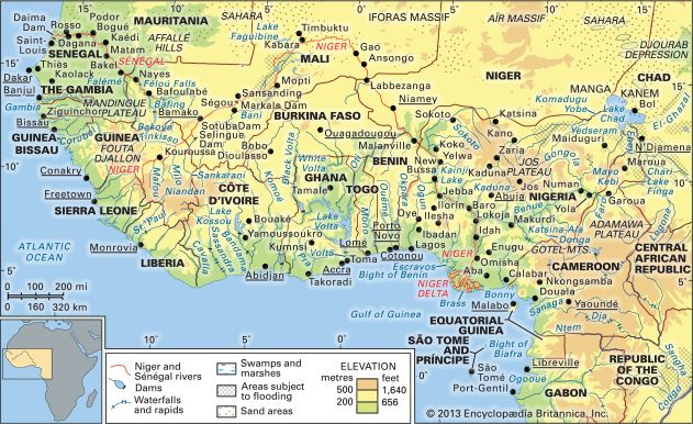
It is important to note that the Mali River in Myanmar is distinct from the drainage systems of the country of Mali, which are primarily defined by the Niger and Sénégal rivers3.
How does the Nmai River differ from the Mali River?
The Nmai River and the Mali River are the two primary headstreams that converge to form the Irrawaddy River in northern Myanmar. While they share a common origin in the glaciers of the remote northern mountains, they differ significantly in their physical characteristics:
- Navigation: The Mali River, which serves as the western branch, features a gentler gradient and contains sections that are partially navigable, despite the presence of some rapids. In contrast, the Nmai River (the eastern branch) is virtually unnavigable due to its powerful current.142
- Volume: The Nmai River carries a greater volume of water than the Mali River.4
- Length: The Nmai River is longer, measuring approximately 300 miles (480 km), whereas the Mali River flows for about 200 miles (320 km).12
Both rivers are essential to the hydrology of the region, ultimately shaping the flow of the Irrawaddy as it moves southward toward the Andaman Sea.4
What is the importance of the Irrawaddy River to Myanmar?
The Irrawaddy River is the principal waterway of Myanmar, serving as the nation’s historical, cultural, and economic heartland. Its importance is defined by several key roles:5
- Economic Arterial: The river is a vital commercial route for transporting goods, including teak, petroleum, cotton, and foodstuffs. The Irrawaddy delta is one of the world’s major rice-growing regions, and the river facilitates the movement of this rice to Yangon for export.6
- Transportation: Despite the development of rail and road networks, the river remains essential for passenger and goods traffic. It provides over 2,000 miles of navigable waterways in the delta and serves as a primary transport link for regions like the Chindwin River valley, which lacks railroads.6
- Historical Significance: As the axis of ancient kingdoms, the river shaped the country’s settlement patterns and political power. Historically, it enabled the rise of civilizations like Pagan by supporting rice cultivation through irrigation and serving as a trade route between India and China.7
- Agriculture: The river and its tributaries, such as the Mu River, are critical for irrigation, supporting dry-season cropping and providing the fertile alluvium necessary for the delta’s agricultural productivity.82
What are river defiles and how are they formed?
A river defile is a narrow passage, gorge, or ravine through which a river flows. These features are essentially a type of canyon or gorge, often characterized by steep, vertical cliffs and a restricted channel width.2910
Formation of Defiles
Defiles and similar narrow valleys are primarily formed through the process of river erosion, specifically accelerated entrenchment. This process typically occurs in the following ways:1110
- Tectonic Uplift and Rejuvenation: When a region undergoes vertical tectonic uplift, it increases the gradient of existing rivers. This “rejuvenation” reinvigorates the river’s erosive power, allowing it to cut deeply into the underlying bedrock rather than widening its valley.10
- Transverse Erosion: Defiles often develop where a river cuts across resistant rock ridges or macrostructures. This can happen through:
- Antecedence: The river was already established in its course before the tectonic features (like folds or faults) rose across its path. If the river’s rate of downcutting keeps pace with the rate of uplift, it maintains its course, carving a deep, narrow passage through the rising structure.10
- Superimposition: A river develops on a layer of younger, softer sediment that buries older, complex rock structures. As the river erodes downward, it is “let down” onto the resistant rocks beneath, forcing it to cut a gorge through them regardless of their orientation.10
- Fault-Guided Erosion: Rivers may preferentially follow existing fault zones that cut across resistant ridges, allowing them to expand through the rock and create a narrow passage.10
Sources
- Mali River — Encyclopædia Britannica
- Irrawaddy River - Physiography — Encyclopædia Britannica
- Mali - Drainage and soils — Encyclopædia Britannica
- Nmai Hka — Encyclopædia Britannica
- Irrawaddy River — Encyclopædia Britannica
- Irrawaddy River - Navigation — Encyclopædia Britannica
- Irrawaddy River - History — Encyclopædia Britannica
- Irrawaddy River - Irrigation — Encyclopædia Britannica
- river - Valleys and canyons — Encyclopædia Britannica
- river - Formation of canyons and gorges — Encyclopædia Britannica
- defiles — Merriam-Webster
- defile — Merriam-Webster
Published on · 3 min read