Tatar Strait
The Tatar Strait is a narrow body of water in the northwest Pacific Ocean that connects the Sea of Japan to the Sea of Okhotsk. It is situated between the…
What is Tatar Strait?
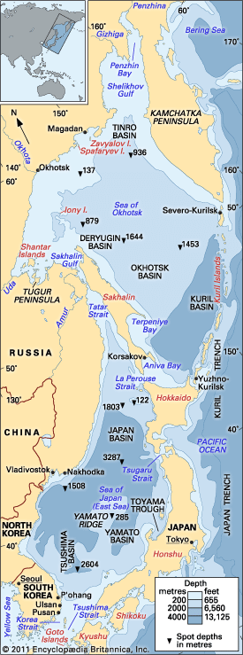
The Tatar Strait is a narrow body of water in the northwest Pacific Ocean that connects the Sea of Japan to the Sea of Okhotsk. It is situated between the Asian mainland and Sakhalin Island.12
Measuring approximately 393 miles (632 km) in length, the strait varies in width from 4.5 to 213 miles (7 to 342 km) and is relatively shallow, with depths generally remaining under 700 feet (210 m). The northern portion of the strait receives the flow of the Amur River. Several Russian ports are located along its shores, including Sovetskaya Gavan and Aleksandrovsk-Sakhalinsky; however, maritime operations in the region are significantly hampered by ice from mid-November through mid-May.1
What is the significance of the Amur River to the region?
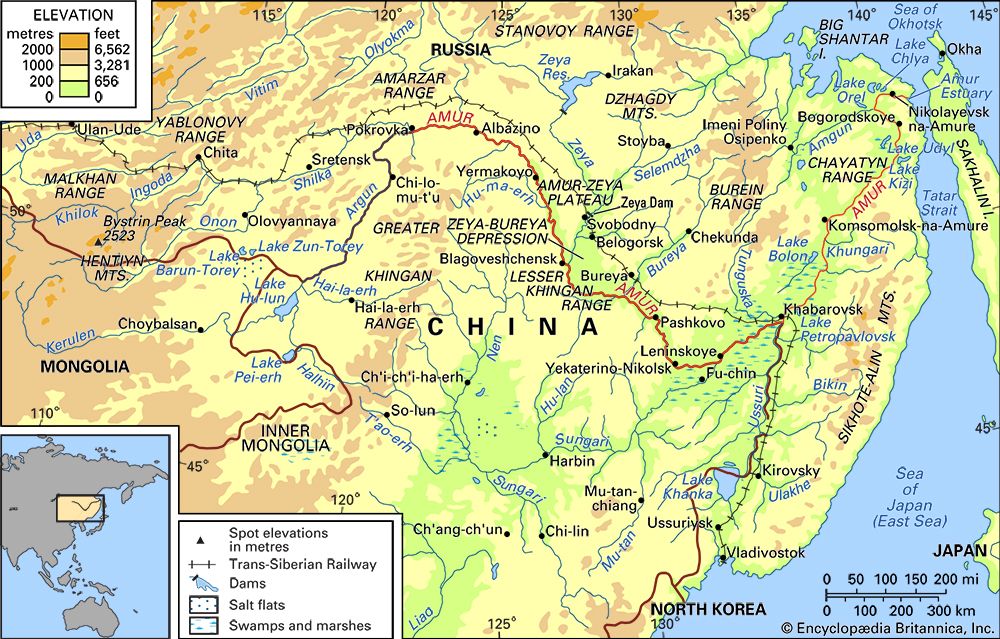
The Amur River is a vital geographic and economic artery in East Asia, serving as the longest river in the Russian Far East and forming a significant portion of the border between China and Russia.3
Its significance to the region is defined by several key factors:
- Economic Navigation: The river and its tributaries serve as essential waterways for trade and transport, connecting numerous Russian and Chinese ports. While its utility fluctuated during periods of geopolitical tension, cooperation between Russia and China has revitalized its role in navigation and regional development.4
- Biological Wealth: The Amur is exceptionally rich in biodiversity, supporting approximately 100 fish species in its lower reaches. With about 25 to 30 species of commercial value, including Siberian salmon and various carp, the river remains a cornerstone of the regional fishing industry.5
- Energy Potential: The basin is increasingly important for its hydroelectric potential, with significant projects like the Zeya and Bureya dams contributing to the region’s power infrastructure.1
- Agricultural Support: The river supports agricultural reclamation efforts in the surrounding marshlands and plains, facilitating cultivation in the fertile lowlands.41
How does the climate affect navigation in the Sea of Okhotsk?
The climate of the Sea of Okhotsk significantly impacts navigation, creating challenging conditions for maritime operations throughout the year.
- Winter Ice: The region experiences a severe continental climate in its northern and western areas, leading to extensive ice cover. Ice begins to form at the end of October and reaches its maximum extent in March. During the winter months, ice floes act as a major impediment to navigation, and in some areas, such as the Sakhalin gulfs and near Shantar Island, ice can persist into July or even August.8
- Summer Fog: While the summer months bring warmer temperatures, navigation remains difficult due to the prevalence of dense fog, which serves as a persistent hindrance to vessels.8
- Navigational Hazards: Beyond climate-driven factors like ice and fog, the sea presents other perils to navigation, including strong currents and submerged rocks, which require careful management for vessels connecting the ports of eastern Russia.8
What is the history of Sakhalin Island?
Sakhalin Island has a complex history defined by shifting control between Russia and Japan. Initially settled by Japanese fishermen in the south, the island saw its first Russian arrivals in the north in 1853. By 1855, the two nations shared control, but in 1875, Russia acquired the entire island in exchange for the Kuril Islands. During this period, the island became notorious as a Russian penal colony.
Following the Russo-Japanese War, the 1905 Treaty of Portsmouth ceded the southern half of the island to Japan, which renamed the territory Karafuto. After the Russian Revolution, Japan occupied the entire island until 1924, and Soviet forces subsequently secured the north. In 1945, at the end of World War II, the Soviet Union regained the southern half, leading to the repatriation of the Japanese population. Today, the island is part of the Sakhalin oblast, established in 1947.91011
Sources
- Tatar Strait — Encyclopædia Britannica
- Tatar Strait — Merriam-Webster
- Amur River — Encyclopædia Britannica
- Amur River - Economy — Encyclopædia Britannica
- Amur River - Animal life — Encyclopædia Britannica
- Amur River - Climate of the Amur River — Encyclopædia Britannica
- Amur — Encyclopædia Britannica
- Sea of Okhotsk — Encyclopædia Britannica
- Sakhalin Island — Encyclopædia Britannica
- Russo-Japanese War - The Treaty of Portsmouth — Encyclopædia Britannica
- Sakhalin — Encyclopædia Britannica
Published on · 3 min read