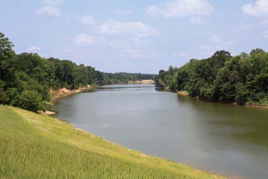
Aksu River
The Aksu River is a significant waterway located in the Xinjiang Uygur Autonomous Region of China. It originates from headstreams in the Tien Shan ("Heavenly…
What is Aksu River?
The Aksu River is a significant waterway located in the Xinjiang Uygur Autonomous Region of China. It originates from headstreams in the Tien Shan (“Heavenly Mountains”) near the town of Aksu and flows approximately 60 miles (100 km) southeastward.1
The river serves as a vital tributary to the Tarim River, which is the primary river system of the Tarim Basin. Notably, the Aksu is the only river in the Tarim system that flows throughout the entire year, making it the most important tributary; it supplies between 70 and 80 percent of the Tarim River’s total water volume.12
What makes the Tarim River unique compared to other major rivers?
The Tarim River is distinguished by several unique hydrographic and environmental characteristics:
- Active Migration: A defining feature of the river is its active migration, meaning its beds and banks frequently shift, often leaving the river with an unformed or poorly defined course.3
- Desert Integration: The term tarim itself designates a river that flows into a lake or becomes indistinguishable from desert sands, a common occurrence for rivers traversing the Takla Makan Desert.3
- Internal Drainage: As the primary river of an internal-drainage basin, the Tarim does not reach the sea. Instead, its waters are subject to intense evaporation and diversion for irrigation, which has historically caused its lower reaches to dry up and transformed its terminus, Lop Nur, into a salt-encrusted lake bed.312
- Dependency on Tributaries: The river is formed by the confluence of several streams, yet it relies heavily on the Aksu River—the only tributary that flows year-round—to provide 70–80 percent of its total water volume.3
How does the Takla Makan Desert influence the region’s climate?
The Takla Makan Desert does not create the region’s climate; rather, its extreme conditions are a result of the surrounding geography. The Tarim Basin, where the desert is located, is enclosed by massive mountain ranges—the Tien Shan, Pamirs, and Kunlun Mountains—which block moist air from the sea, resulting in an extremely dry, continental climate with annual rainfall as low as 0.4 inches (10 mm) in the east.36
The desert itself influences local atmospheric conditions through its physical properties:
- Dust Storms: In spring, warming surface sands trigger ascending air currents and strong northeasterly winds. These generate hurricane-force dust storms that can propel dust up to 13,000 feet (4,000 metres) into the atmosphere.7
- Atmospheric Shroud: Winds from various directions frequently lift dust into the air, covering the desert in a shroud for nearly the entire year.7
- Temperature Extremes: The desert’s landscape contributes to a markedly continental climate with a maximum annual temperature range of 70 °F (39 °C), featuring hot summers and cold winters.7
What are the Tien Shan mountains and why are they important to the region’s water supply?
The Tien Shan, meaning “Celestial Mountains,” is a massive mountain system in Central Asia stretching approximately 1,500 miles (2,500 km) across the borders of China, Kyrgyzstan, and Kazakhstan.9
These mountains are vital to the region’s water supply due to their extensive glaciation. The range contains roughly 3,900 square miles of glaciers, including the massive Engil’chek Glacier. These glaciers and the seasonal snowpack act as a critical water reservoir for the surrounding arid regions.23
The importance of the Tien Shan to the regional water supply includes:
- River Feeding: The melting snow and ice from the Tien Shan feed numerous major rivers, including the Aksu River, which is the primary water source for the Tarim River, providing 70–80 percent of its total volume.32
- Seasonal Regulation: The high-water period for rivers in the Tarim Basin occurs from May through September, directly driven by the melting snows of the Tien Shan and Kunlun Mountains.3
- Agricultural Support: The runoff from these mountains supports extensive irrigation schemes in the foothill valleys, which are essential for agriculture in an otherwise extremely dry environment.310
Sources
- Aksu River — Encyclopædia Britannica
- Tarim River — Encyclopædia Britannica
- Tarim Basin — Encyclopædia Britannica
- Takla Makan Desert - Drainage — Encyclopædia Britannica
- Xinjiang - Drainage — Encyclopædia Britannica
- Takla Makan Desert - Climate — Encyclopædia Britannica
- Takla Makan Desert — Encyclopædia Britannica
- Takla Makan Desert - Physical features — Encyclopædia Britannica
- Tien Shan — Encyclopædia Britannica
- Tien Shan - Glaciation — Encyclopædia Britannica
- Tien Shan - Drainage — Encyclopædia Britannica
Published on · 3 min read