Apurímac River
The Apurímac River is a significant river in southern Peru that serves as the farthest source of the Amazon River. It originates at approximately 17,000 feet…
What is Apurímac River?
The Apurímac River is a significant river in southern Peru that serves as the farthest source of the Amazon River. It originates at approximately 17,000 feet (5,200 meters) from the snowmelts of Mount Mismi in the Arequipa region.1
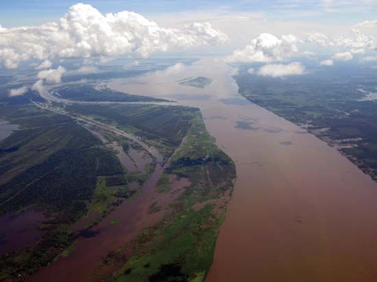
Flowing northwest through the Andes, the river spans about 430 miles (700 kilometers), characterized by narrow canyons and a torrential course marked by frequent rapids and falls. As it progresses, its name changes: it is known as the Apurímac until it meets the Mantaro River, then as the Ene, and finally as the Tambo before joining the Urubamba River. The confluence of the Apurímac and Urubamba rivers forms the Ucayali River, a major headwater of the Amazon.12
How does the Amazon River form?
The Amazon River is formed through a complex system of headwaters originating in the Andes Mountains of Peru. Its formation can be understood through the following progression:23
- Farthest Source: The Apurímac River, which rises from snowmelts on Mount Mismi, is considered the farthest source of the Amazon system.4
- Confluence of Headwaters: The Apurímac joins the Urubamba River to form the Ucayali River.145
- The Main Stream: The Ucayali flows northward until it meets the Marañón River. This confluence is widely considered to mark the head of the Amazon.16
- Tributary Contributions: Throughout its course, the river is fed by more than 1,000 tributaries, including major systems like the Negro and Madeira rivers, which significantly increase its volume as it flows eastward across the continent to the Atlantic Ocean.62
What are the major mountain ranges in Peru?
The Andes Mountains form the primary mountain system in Peru, characterized by high, rugged terrain and significant tectonic activity. While often described as three distinct backbones—the Cordillera Occidental, Cordillera Central, and Cordillera Oriental—these specific designations are not used within Peru itself. Instead, the mountains are organized into complex chains and “knots” (nudos) where ranges converge.89
Key features of the Peruvian Andes include:
- Cordillera Blanca: Located in central Peru, this range is famous for its snowcapped peaks, including Mount Huascarán, the country’s highest point at 22,205 feet (6,768 meters).89
- Cordillera Negra: Situated west of the Cordillera Blanca, it is lower in elevation and lacks permanent snow cover.9
- Southern Ranges: In southern Peru, the landscape transitions into the Puna, a high plateau region. This area features a volcanic chain that includes peaks such as Misti.8
- Vilcanota and Vilcabamba Ranges: These chains emerge from the Vilcanota Knot in the south, contributing to the rugged topography near Cuzco.9
How do rivers change as they flow from mountains to lowlands?
As rivers flow from mountains toward lowlands, they undergo significant geomorphic changes driven by their adjustment to a baselevel, which is typically sea level.11
Valley Evolution
In their initial stages within mountainous regions, rivers primarily expend energy on vertical entrenchment. This creates narrow, deep valleys and canyons, often characterized by steep gradients and features like waterfalls or knickpoints. As rivers continue to erode the landscape, they gradually smooth out their longitudinal profiles, eventually eliminating most waterfalls. As they approach their baselevel, rivers shift their energy from vertical downcutting to lateral erosion, which progressively broadens the valley floor.12
Channel Dynamics
The physical characteristics of a river also evolve downstream:
- Slope and Efficiency: While there is a marked downstream decrease in channel slope, this does not necessarily result in slower flow. Instead, the reduction in slope is offset by increased channel efficiency, often due to a larger channel size.13
- Floodplain Development: In lowland areas, rivers often develop floodplains through lateral migration and overbank flow. The total thickness of sediment in these areas is largely controlled by the rate at which a river migrates across its valley.14
- Equilibrium: Rivers are often viewed as quasi-equilibrium systems, constantly adjusting variables such as width, depth, and sediment transport in relation to discharge.13
Sources
- Apurímac River — Encyclopædia Britannica
- Ucayali River — Encyclopædia Britannica
- Amazon River - Physiography of the river course — Encyclopædia Britannica
- Amazon River — Encyclopædia Britannica
- Urubamba River — Encyclopædia Britannica
- Amazon River - Hydrology of the Amazon River — Encyclopædia Britannica
- Amazon River: Top Questions — Encyclopædia Britannica
- Peru - The Sierra, or Andean, region — Encyclopædia Britannica
- Andes Mountains - Physiography of the Central Andes — Encyclopædia Britannica
- Andes Mountains - Climate — Encyclopædia Britannica
- valley - Geomorphic characteristics — Encyclopædia Britannica
- river - Hydraulic geometry — Encyclopædia Britannica
- river - Valley evolution — Encyclopædia Britannica
- river - Straight channels — Encyclopædia Britannica
- river - Time and the floodplain system — Encyclopædia Britannica
Published on · 3 min read