Azuero Peninsula
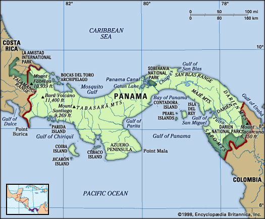
The Azuero Peninsula is a physical region located in southwestern Panama. It extends southward into the Pacific Ocean, situated between the Gulf of Panama to…
What is Azuero Peninsula?
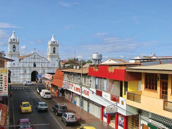
The Azuero Peninsula is a physical region located in southwestern Panama. It extends southward into the Pacific Ocean, situated between the Gulf of Panama to the east and the Gulf of Montijo to the west.1
The peninsula spans approximately 60 miles (100 km) from east to west and 55 miles (90 km) from north to south. Its highest point is Mount Canajagua, which reaches an elevation of 3,068 feet (935 m) southwest of Las Tablas. The region’s primary urban centers, Chitré and Las Tablas, maintain connectivity to the rest of the country via the Pan-American Highway.1
What is the climate like on the Azuero Peninsula?
The Azuero Peninsula is located on the Pacific side of Panama, which dictates its specific climatic patterns. As part of the Pacific region, the peninsula experiences a tropical climate characterized by seasonal variation in rainfall, distinct from the year-round precipitation found on the Caribbean coast.2
The Pacific region typically receives between 45 and 90 inches (1,140–2,290 mm) of rain annually, with a pronounced dry season that generally lasts from January through April. Due to its tropical location, temperatures remain consistently warm, with the mean temperature of the coldest month rarely dropping below 78 °F (26 °C).2
Topography also influences the local climate; while most of the peninsula consists of a hot, low-lying zone below 2,300 feet (700 meters), higher elevations such as Mount Canajagua reach into a temperate zone, which can alter local temperature and vegetation patterns. The seasonally dry conditions of the region are particularly conducive to the presence of savannas, or tropical grasslands.21
What are some traditional cultural festivals held in this region?
The Azuero Peninsula is a significant center for the preservation of Panamanian traditions, with several municipalities hosting festivals that celebrate the country’s rural heritage and religious customs.3
Key cultural festivals in the region include:
- Mejorana Festival: Held in the town of Guararé, this event is dedicated to the folklife of Panama’s rural provinces, showcasing traditional music and customs.3
- Semana Santa (Holy Week): Several municipalities across the region sponsor these religious festivals, with the small town of Villa de los Santos being particularly notable for its observances.3
- Carnival: Like much of Panama, the region participates in this boisterous pre-Lenten celebration, which is characterized by music, dancing, and festivities.3
While these events highlight the cultural vibrancy of the peninsula, the government also actively promotes the preservation of folk music and folk dances throughout the nation to maintain these historical practices.3
How does the geography of Panama influence its biodiversity?
Panama’s exceptional biodiversity is primarily a result of its unique geography as an ancient land bridge connecting North and South America. This position has allowed for a rich intermixture of species from both continents, resulting in a diverse array of wildlife that includes South American mammals like sloths, anteaters, and armadillos, alongside North American species such as jaguars, tapirs, and deer.4
The country’s varied topography further enhances this biological richness. A central spine of mountain ranges divides the nation into Atlantic- and Pacific-facing slopes, creating a wide range of habitats including tropical rainforests, savannas, cool montane forests, mangrove swamps, and coral reefs. These mountain slopes also create distinct climatic zones—ranging from hot lowlands to temperate and cold zones—each supporting characteristic plant growth and specialized ecosystems.425
Additionally, the region’s diverse landscapes are protected by an extensive system of national parks, which cover about one-sixth of the country’s land area. These protected zones, such as the Darién National Park, serve as critical refuges for a vast array of flora and fauna.46
Sources
- Azuero Peninsula — Encyclopædia Britannica
- Panama - Climate of Panama — Encyclopædia Britannica
- Panama - Sports and recreation — Encyclopædia Britannica
- Panama - Plant and animal life — Encyclopædia Britannica
- Panama - Relief — Encyclopædia Britannica
- Darién — Encyclopædia Britannica
Published on · 3 min read