Barbados Ridge
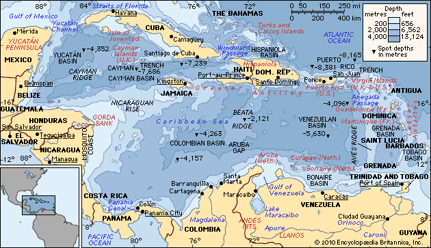
The Barbados Ridge is a submarine ridge located in the Caribbean Sea. It rises from the southern end of the axis of the Puerto Rico Trench.
What is Barbados Ridge?
The Barbados Ridge is a submarine ridge located in the Caribbean Sea. It rises from the southern end of the axis of the Puerto Rico Trench.1
The ridge is characterized by a shallow trough running parallel on either side. It is structurally linked to the Puerto Rico Trench, as evidenced by the extension of negative gravity anomalies—which indicate a mass deficiency deep within the Earth—across both features. It is important to distinguish this geological formation from the terrestrial topography of the island of Barbados, such as the Christ Church Ridge, which is formed by different geological processes.12
What is an accretionary complex?
An accretionary complex is a geological feature formed at a convergent plate boundary where an oceanic plate is being subducted beneath another plate. As the oceanic plate descends, sediments and fragments of oceanic crust are scraped off the top of the subducting slab and accumulated against the edge of the overriding plate.
This process creates a chaotic, deformed wedge of material known as an accretionary prism or complex. Over time, this material is compressed, folded, and faulted, often rising to form submarine ridges or even island arcs. The Barbados Ridge serves as a prominent example of such a feature, representing a massive accumulation of sediments scraped from the Atlantic floor as it subducts beneath the Caribbean Plate.
How do tectonic plates interact to form underwater ridges?
Underwater ridges are primarily formed at divergent plate boundaries, where tectonic plates move away from each other in a process known as seafloor spreading.334
The formation process involves several key mechanisms:
- Magma Upwelling: As plates diverge, the gap between them is filled by molten rock (magma) rising from the mantle. This material solidifies to create new oceanic crust.34
- Thermal Expansion: The new crust and the underlying mantle at these spreading centers are extremely hot. This heat causes the lithosphere to expand, creating elevated topography that rises 2 to 3 km above the surrounding seafloor.34
- Gravitational Forces: The elevated ridge creates a feedback scenario where gravitational forces help push the plates apart, further facilitating the upwelling of magma and sustaining the ridge’s height.3
- Cooling and Contraction: As the oceanic plates move away from the spreading center, they gradually cool and contract. This thermal contraction causes the seafloor to deepen over time, which is why the depth of the ocean floor is proportional to the square root of the crust’s age.5
While most ridges are formed by this spreading process, other submarine features, such as seamounts and certain aseismic ridges, are produced by volcanic activity.4
What are gravity anomalies and why do they occur?
A gravity anomaly is the difference between the locally observed value of gravity and the theoretically calculated value for a specific location. These anomalies are essential tools in geophysical prospecting because they reflect local variations in the density of underlying rocks.78
Gravity anomalies occur primarily due to subsurface density contrasts. When denser rocks are brought closer to the surface—such as through geological uplifts or faulting—they create positive gravity anomalies. Conversely, features composed of less dense material, such as salt domes or subterranean cavities, typically produce negative anomalies.8
To isolate these geological signals, scientists use gravimeters to measure minute differences in gravitational acceleration, often as small as 0.01 milligal. Because observed readings are influenced by external factors, data must be corrected for variations in elevation, latitude, and other environmental conditions to accurately map the density of the Earth’s crust. These measurements are vital for locating natural resources like oil and minerals, as well as identifying hidden geological structures.8
Sources
- Barbados Ridge — Encyclopædia Britannica
- Barbados - Relief, drainage, and soils — Encyclopædia Britannica
- oceanic ridge - Principal characteristics — Encyclopædia Britannica
- plate tectonics - Seafloor spreading — Encyclopædia Britannica
- ocean basin - General features — Encyclopædia Britannica
- Indian Ocean - Seamounts of the Indian Ocean — Encyclopædia Britannica
- gravity anomaly — Merriam-Webster
- Earth exploration - Gravity methods — Encyclopædia Britannica
Published on · 3 min read