Bay of Bengal
Several major rivers flow into the Bay of Bengal, significantly shaping its hydrology and ecosystem. On the northern coast, the Ganges and Brahmaputra rivers…
What major rivers flow into the Bay of Bengal, and how do they affect its ecosystem?
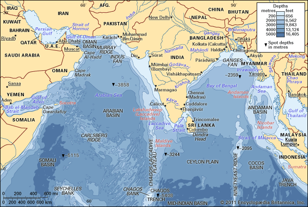
Several major rivers flow into the Bay of Bengal, significantly shaping its hydrology and ecosystem. On the northern coast, the Ganges and Brahmaputra rivers deliver a massive volume of fresh water and the world’s highest annual suspended sediment load, totaling approximately 1.84 billion tons. Other major rivers, including the Mahanadi, Godavari, Krishna, and Kaveri, drain into the western side of the bay.123
Ecosystem Impact
The influx of fresh water from these rivers creates a distinct tropical marine ecosystem in the northern bay. This drainage, combined with extensive wetlands, marshes, and mangrove forests, enhances the productivity of nearshore fish species. However, this fresh water runoff also lowers surface salinity to less than 32 parts per thousand, which restricts certain oceanic species, such as tuna, to the deeper, southern sectors of the bay.45
While these rivers support biodiversity, they also carry environmental risks. Runoff containing agricultural fertilizers can lead to eutrophication, causing algal blooms that deplete oxygen and threaten aquatic life. Furthermore, industrial waste and untreated sewage discharged into these waterways can introduce toxic pollutants that accumulate in the food chain.67
What are the geographical boundaries and size of the Bay of Bengal?
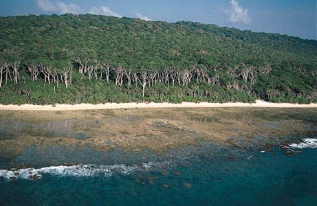
The Bay of Bengal is a large embayment of the northeastern Indian Ocean covering an area of approximately 839,000 square miles (2,173,000 square km). It is situated roughly between latitudes 5° and 22° N and longitudes 80° and 90° E.2
Geographical Boundaries
The bay is defined by the following borders:
- West: India and Sri Lanka.
- North: Bangladesh.
- East: Myanmar and the northern part of the Malay Peninsula.
- South: According to the International Hydrographic Bureau, the southern boundary stretches from Dondra Head at the southern tip of Sri Lanka to the northern tip of the Indonesian island of Sumatra.2
The bay spans about 1,000 miles (1,600 km) in width and is separated from the Andaman Sea by the Andaman and Nicobar island groups.2
What role did the Bay of Bengal play in ancient maritime trade routes?
The Bay of Bengal served as a vital maritime corridor for ancient trade, connecting the Indian subcontinent with Southeast Asia and beyond. By the 1st century CE, the Periplus Maris Erythraei—a Greek sailing manual—documented routes from the Red Sea to the eastern coast of India and the Ganges delta. By the 2nd century CE, Ptolemy described voyages crossing the bay toward the Strait of Malacca, suggesting that Indian and Malayan navigators had long utilized these waters for commerce.8
These maritime networks facilitated more than just the exchange of goods; they were instrumental in the transmission of Buddhism and Hinduism to Southeast Asia. Trade also spurred colonization, with significant activity occurring between the 1st and 10th centuries CE. Ports such as Tamralipti in the Ganges delta acted as major hubs, linking internal Indian river routes to the broader Indian Ocean network. Later, during the Mughal dynasty, ports like Chittagong and Hooghly continued to supply textiles and food items to overseas markets.28910
What are some of the major port cities located along the Bay of Bengal?
Several major port cities are located along the coastline of the Bay of Bengal, serving as critical hubs for regional and international trade. These ports facilitate the movement of diverse cargoes, including raw materials, agricultural products, and manufactured goods.13
Principal Ports by Country
- India: Key ports include Kolkata, Haldia, Vishakhapatnam, Chennai, Cuddalore, and Paradeep. Haldia, Vishakhapatnam, and Paradeep are particularly notable for their development as iron ore terminals.1314
- Bangladesh: Chittagong serves as the country’s chief port and a vital gateway for foreign trade. Dhaka is also recognized as a noteworthy center for commerce.134
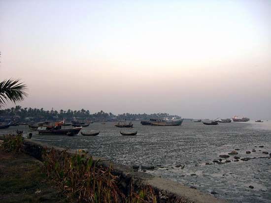
- Myanmar: Sittwe (formerly Akyab) is the country’s chief port on the bay. Additionally, Pathein functions as a deepwater port, and Mawlamyine remains an important port for the export of goods like teak and rice.131516
- Sri Lanka: The ports of Colombo and Trincomalee are of significant importance to maritime transportation in the region.13
Sources
- Ganges River - Physiography — Encyclopædia Britannica
- Bay of Bengal — Encyclopædia Britannica
- Brahmaputra River - Physiography — Encyclopædia Britannica
- Bay of Bengal - Resource exploitation — Encyclopædia Britannica
- river - Environmental problems attendant on river use — Encyclopædia Britannica
- Barak River — Encyclopædia Britannica
- Indian Ocean - Surface salinity — Encyclopædia Britannica
- Bay of Bengal - Study and exploration — Encyclopædia Britannica
- Buddhism - Southeast Asia — Encyclopædia Britannica
- Mughal dynasty - Economy and trade — Encyclopædia Britannica
- Monsoon Current — Encyclopædia Britannica
- India - Contacts with the West — Encyclopædia Britannica
- Bay of Bengal - Transportation — Encyclopædia Britannica
- Chittagong — Encyclopædia Britannica
- Pathein — Encyclopædia Britannica
- Mawlamyine — Encyclopædia Britannica
- Ganges River - Navigation — Encyclopædia Britannica
Published on · 3 min read