Bruny Island
Bruny Island is a 35-mile-long island located off the southeastern coast of Tasmania, Australia. It is a popular holiday destination characterized by its…
What are the main attractions and natural features of Bruny Island?
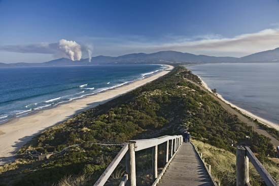
Bruny Island is a 35-mile-long island located off the southeastern coast of Tasmania, Australia. It is a popular holiday destination characterized by its rugged natural beauty and unique geography.
Natural Features
- Geography: The island is divided into northern and southern sections connected by a narrow isthmus. It features a rugged east coast and is deeply indented by several bays, including Adventure, Cloudy, and Great Taylor bays.
- Topography: The landscape is generally wooded and mountainous in the south, with Mt. Bruny reaching an elevation of 1,659 feet (506 meters).
- Coastal Landmarks: The D’Entrecasteaux Channel lies to the west, Storm Bay to the northeast, and the Friars Rocks are situated just offshore to the south.
Attractions
Today, the island serves primarily as a tourist destination. Visitors typically travel from Hobart via a ferry from Kettering to explore the island’s settlements, which include Adventure Bay, Alonnah, and Lunawanna, connected by a road running from Dennes Point to Cape Bruny.1
How did Bruny Island get its name, and what is its history?
Bruny Island was named after the French explorer Bruni d’Entrecasteaux, who navigated the island’s coastal waters in 1792. While the island was first sighted by the Dutch navigator Abel Tasman in 1642, it was d’Entrecasteaux who later surveyed the area and identified the D’Entrecasteaux Channel as a channel rather than a bay.12
Following European settlement, the island initially functioned as a whaling base. Throughout the 20th century, the island experienced a population decline, shifting its economic focus away from its early industrial roots. Today, the island has transitioned into a popular holiday destination and tourist attraction, with visitors traveling from Hobart via a ferry from Kettering to explore its settlements and natural landscape.1
How do locals and tourists travel to and around Bruny Island?
Travel to and around Bruny Island relies on a combination of ferry services and a primary road network.
Accessing the Island
Visitors and locals typically reach the island by taking a passenger and vehicle ferry that operates from Kettering, located on the southeastern coast of Tasmania. This ferry service provides the essential link between the Tasmanian mainland and the island, facilitating both tourism and local transit.13
Traveling Around the Island
Once on the island, transportation is primarily facilitated by a single, main road that spans the length of the island. This road runs from Dennes Point in the north down to Cape Bruny in the south. It serves as the primary artery for navigation, connecting the island’s various settlements, including:
- Simpsons Bay
- Adventure Bay
- Alonnah
- Lunawanna1
This road network allows travelers to traverse the northern and southern sections of the island, which are joined by a narrow isthmus.1
We could dive deeper into the geography of the island’s isthmus or the history of the ferry service connecting it to the mainland.
How does the climate of Bruny Island differ from mainland Tasmania?
Sorry, the Britannica knowledge base does not contain information regarding how the climate of Bruny Island specifically differs from that of mainland Tasmania.
Sources
- Bruny Island — Encyclopædia Britannica
- D’Entrecasteaux Channel — Encyclopædia Britannica
- Tasmania - Transportation and telecommunications — Encyclopædia Britannica
- Tasmania — Encyclopædia Britannica
Published on · 2 min read