Cape Howe
Cape Howe is the southeastern point of mainland Australia, situated at the border between the states of Victoria and New South Wales, approximately 300 miles…
What is Cape Howe?
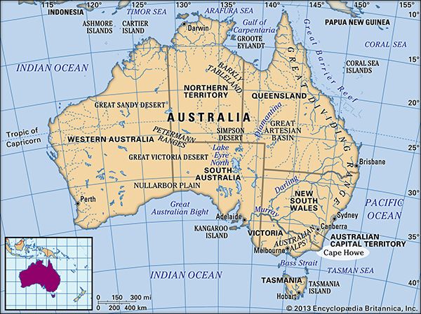
Cape Howe is the southeastern point of mainland Australia, situated at the border between the states of Victoria and New South Wales, approximately 300 miles (560 km) southwest of Sydney.1
It serves as the southern portal to Disaster Bay, an inlet of the Tasman Sea. The cape is characterized by the prominent landmark of Howe Hill, which rises to an elevation of 1,297 feet (395 m). The site was first sighted in 1770 by the British navigator Captain James Cook, who named the feature in honor of Richard, Lord Howe, the treasurer of the Royal Navy at that time.1
Who was Captain James Cook and what were his major voyages?
James Cook (1728–1779) was a renowned British naval captain, navigator, and explorer who fundamentally transformed global cartography through his three major expeditions to the Pacific Ocean.345
Major Voyages
- First Voyage (1768–1771): Commanding the HMS Endeavour, Cook was tasked with observing the transit of Venus in Tahiti and searching for the hypothetical southern continent. He circumnavigated New Zealand and charted the eastern coast of Australia, navigating the Great Barrier Reef.65
- Second Voyage (1772–1775): Aboard the Resolution and Adventure, Cook conducted the first west-east circumnavigation in high latitudes. He disproved the existence of a temperate southern continent, charted numerous islands including Tonga and New Caledonia, and reached the Antarctic ice fields.65
- Third Voyage (1776–1779): Seeking a Northwest Passage, Cook explored the North Pacific, locating the Hawaiian Islands. He was killed in 1779 during a conflict with indigenous Hawaiians at Kealakekua Bay.65
Cook is celebrated for his scientific rigor, his humane treatment of indigenous peoples, and his success in preventing scurvy among his crews.65
How do state borders in Australia typically get determined?
State borders in Australia were primarily determined through the administrative division of the original British colony of New South Wales as European settlement expanded during the 19th century.
Rather than following a single uniform process, the creation of new colonies—which later became states—was often driven by the demands of settlers for local autonomy, better representation, and control over their own regional revenues. For example, the Port Phillip District was separated from New South Wales and established as the colony of Victoria in 1851 via the Australian Colonies Government Act, a legislative action by the British House of Commons in response to settler grievances. Similarly, Queensland was formed in 1859 after calls for independence from the northern portions of New South Wales.
These colonial boundaries were eventually solidified when the colonies federated to form the Commonwealth of Australia in 1901, at which point the former colonies became states with defined constitutional powers.
What other landmarks did Captain Cook name during his travels?
During his extensive voyages, Captain James Cook charted and identified numerous landmarks and territories across the globe. While his primary mission was scientific exploration, his meticulous surveying significantly updated the world map.
Beyond his well-known charting of New Zealand and the eastern coast of Australia, Cook’s expeditions led to the discovery or detailed mapping of several other notable locations:
- Pacific Islands: During his second voyage, he charted lands including the Cook Islands, the Marquesas, Fiji, Niue, Tonga, New Caledonia, Vanuatu, and Norfolk Island.5
- Atlantic and Southern Regions: He discovered the South Sandwich Islands and South Georgia island in the Atlantic.6
- North Pacific: During his third voyage, he located Kiritimati Atoll (Christmas Island) and the Hawaiian Islands, which he referred to as the Sandwich Islands.56
Cook’s work was characterized by an exactitude previously unknown in maritime history, effectively filling in the remaining gaps of 18th-century oceanic exploration.56
Sources
- Cape Howe — Encyclopædia Britannica
- Australia - The Dutch — Encyclopædia Britannica
- James Cook: Top Questions — Encyclopædia Britannica
- James Cook — Encyclopædia Britannica
- Pacific Islands - The 18th century — Encyclopædia Britannica
- James Cook - Voyages and discoveries — Encyclopædia Britannica
- Australia - Settlement — Encyclopædia Britannica
- Colonization of Australia - Founding Victoria — Encyclopædia Britannica
- Victoria - European exploration and settlement — Encyclopædia Britannica
- Australia - Movement toward federation — Encyclopædia Britannica
- Australian Colonies Government Act — Encyclopædia Britannica
- Hawaii - The arrival of Europeans — Encyclopædia Britannica
Published on · 3 min read