Caspian Depression
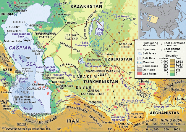
The Caspian Depression is a vast, flat lowland located at the northern end of the Caspian Sea, spanning across parts of Russia and Kazakhstan. Covering…
What is Caspian Depression?
The Caspian Depression is a vast, flat lowland located at the northern end of the Caspian Sea, spanning across parts of Russia and Kazakhstan. Covering approximately 77,220 square miles (200,000 square km), it is one of the largest such regions in Central Asia, with much of its territory situated below sea level.1
The landscape is characterized by an arid climate, with sparse annual rainfall ranging from 6 to 12 inches (150 to 300 mm). The Volga and Ural rivers traverse the depression before emptying into the sea. Due to the dry conditions, intensive cultivation is limited to isolated oases, and the region is primarily utilized for sheep grazing. Economically, the area is significant for its extraction of salt and the presence of the Zhem River oil fields.1
How do the Volga and Ural rivers impact the Caspian Sea?
The Volga and Ural rivers are critical to the Caspian Sea, as they, along with the Terek River, provide approximately 88 percent of the total river water entering the basin. Their impact is multifaceted:4
- Hydrology and Water Levels: These rivers are primary drivers of the sea’s water balance. Fluctuations in their inflow—influenced by climate change and human activity—directly affect the sea’s surface level. For instance, reservoir construction and water diversion on the Volga for irrigation and industry have historically reduced discharge, contributing to declines in the sea’s level. Conversely, periods of increased inflow from the Volga have helped raise the water level.567
- Shoreline Formation: The northern Caspian shores are characterized by low-lying terrain shaped by the massive accumulation of alluvial material deposited by these rivers, which have formed extensive deltas.4
- Water Chemistry: The influx of river water significantly influences the sea’s salinity. Near the Volga outlet, salinity is as low as 1 part per thousand, and the overall river inflow contributes to the sea’s lower chloride content compared to the ocean.5
- Ecology: The rivers serve as vital spawning grounds for anadromous fish species, such as the beluga sturgeon.6
What makes the Caspian Sea’s climate so diverse?
The Caspian Sea exhibits a remarkable diversity in climate due to its vast latitudinal span and the influence of varied surrounding geographical features. The region is divided into distinct climatic zones: the northern area experiences a moderately continental climate, while the middle and southern regions fall within a warm continental belt, with subtropical influences reaching the southwest and a desert climate dominating the eastern shore.2
This variety is driven by several atmospheric and topographical factors:
- Atmospheric Circulation: In winter, the region is dominated by cold, clear air from the Asiatic anticyclone. In summer, the area is influenced by the Azores high-pressure and South Asian low-pressure centers.2
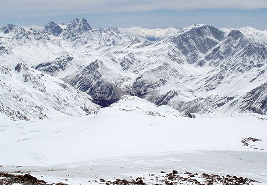
- Topographical Barriers: The Caucasus Mountains play a significant role by blocking cyclonic disturbances that arrive from the west, which complicates local weather patterns and contributes to the prevalence of strong northerly, northwesterly, and southeasterly winds.2
- Temperature and Precipitation Gradients: Average winter temperatures vary drastically, ranging from 14 °F (−10 °C) in the north to 50 °F (10 °C) in the south. Annual precipitation is similarly uneven, with the least occurring in the arid east and the highest levels recorded in the southwestern region.2
Why is the Caspian Depression important for the oil industry?
The Caspian Depression is a vital region for the oil industry due to its significant hydrocarbon reserves and the presence of major extraction sites. The area includes the important Zhem River oil fields, which have long contributed to the region’s economic output.1
Furthermore, the northeastern portion of the Caspian Sea and its adjacent shores are considered to hold some of the most promising petroleum and natural gas reserves in the region petroleum and natural gas reserves in the region. Notable developments in this area include:10
- Tengiz Field: Located on the northeast border of the Caspian Sea, this supergiant field contains up to 9 billion barrels of recoverable reserves. Its development is technically complex due to high well pressure and the presence of hydrogen sulfide gas.8
- Kashagan Field: Discovered in 2000 in the northern Caspian, this is one of the largest conventional fields found in recent decades, with estimated proven reserves of 30 billion barrels.8
Exploitation of these resources, which began in the 1920s, has expanded significantly, utilizing drilling platforms and artificial islands to access seabed deposits.9
Sources
- Caspian Depression — Encyclopædia Britannica
- Caspian Sea - Climate — Encyclopædia Britannica
- Caspian Sea - Submarine features — Encyclopædia Britannica
- Caspian Sea - Hydrology — Encyclopædia Britannica
- Caspian Sea - Shoreline features — Encyclopædia Britannica
- Volga River - Environmental changes — Encyclopædia Britannica
- Caspian Sea — Encyclopædia Britannica
- Caspian Sea - Geology of the Caspian Sea — Encyclopædia Britannica
- petroleum - Russia and the Caspian Sea region — Encyclopædia Britannica
- Caspian Sea - Resources — Encyclopædia Britannica
Published on · 3 min read