Cévennes
The Cévennes is a mountain range located in southern France that forms the southeastern rim of the Massif Central. Reaching elevations over 5,000 feet (1,525…
What is Cévennes?
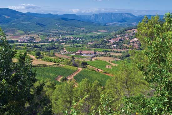
The Cévennes is a mountain range located in southern France that forms the southeastern rim of the Massif Central. Reaching elevations over 5,000 feet (1,525 m), the range overlooks the Rhône River valley and the Languedoc plain.12
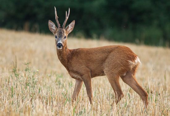
The region is characterized by deep valleys carved by torrents and is home to the Cévennes National Park, a protected area established in 1970 that spans the départements of Lozère and Gard. While the name Cévennes historically signifies “wooded slopes,” the area has faced significant deforestation, leading to ongoing state-led reforestation efforts. Economically, the region features agriculture in its valleys—including grapes and olives—and a declining coal industry centered in Alès. The national park itself is a diverse ecosystem featuring limestone plateaus, extensive forests, and a variety of wildlife, including roe deer and rare orchids like the lady’s slipper.13
What is the Massif Central?
The Massif Central is a vast upland region in south-central France, covering approximately one-sixth of the country’s total area (33,000 square miles). Conventionally defined by the 1,000-foot contour line, the region consists primarily of plateaus ranging from 2,000 to 3,000 feet in elevation, punctuated by significant peaks such as Puy de Sancy (6,184 feet) and the Plomb du Cantal.4
Geologically, the area is complex, featuring crystalline rocks formed during the Hercynian period, as well as extensive volcanic formations resulting from activity that began in the Pliocene Epoch. This volcanic history created the region’s distinctive cones and plateaus, which are deeply dissected by river valleys.4
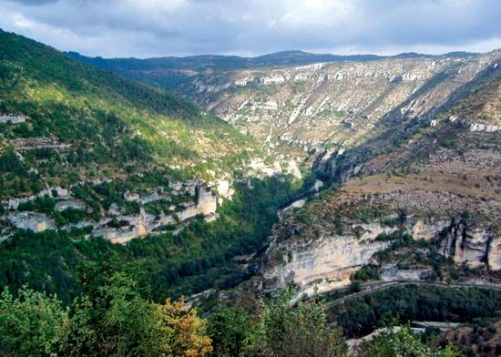
The Massif Central is divided into seven physiographic areas, including the Morvan, the Cévennes, and the Causses, a limestone region known for its dramatic gorges. While historically rural and agricultural, the region has seen demographic shifts and economic restructuring as traditional industries like coal mining have declined. Today, the economy relies on dairy farming, food processing, hydroelectric power, and an expanding tourism sector.4
What kind of wildlife lives in the Cvennes National Park?
The Cévennes National Park supports a diverse range of wildlife, benefiting from the protection of its varied landscape of limestone plateaus and extensive forests.2
Fauna
The park is home to a variety of mammals and birds, many of which have seen population stabilization following the park’s establishment in 1970:2
- Mammals: The region hosts populations of roe deer, moufflons, wild boars, otters, badgers, foxes, and martens.2
- Birds: Despite historical declines due to hunting, the park remains a habitat for several notable species, including golden eagles, peregrine falcons, eagle owls, hen harriers, Montague’s harriers, stone curlews, and little bustards.2
Flora
The park’s botanical diversity is significant, featuring approximately 1,700 species of flowering plants. Notable flora includes:2
- Orchids and Lilies: The lady’s slipper orchid, martagon lilies, and wild daffodils.2
- Forests and Grasses: The landscape is dominated by forests of chestnut, beech, birch, Scots pine, and various oak species, alongside grasses such as matgrass and hair grass.2
How do limestone plateaus shape the landscape of this region?
Limestone plateaus, known locally as Causses, profoundly shape the landscape of the Massif Central through unique geological and hydrological processes. These regions are characterized by a karst topography, where the dissolution of soluble bedrock creates a distinct, often barren, and stony environment.64
The landscape is defined by several key features:
- Gorges and Canyons: Rivers such as the Tarn and Aveyron have carved deep, imposing canyons into the limestone, creating dramatic vertical relief that contrasts with the flat, elevated surfaces of the plateaus.67
- Subsurface Drainage: Because limestone is permeable, surface water often disappears into the ground through joints and fractures. This process creates dry valleys where surface streams have been diverted into underground cave systems.78
- Karst Features: The surface is frequently pocked with sinkholes (locally called avens) and depressions formed by the collapse of cave roofs or bedrock dissolution. These openings often lead to extensive underground grottoes and cavern systems.69
- Settlement Patterns: Due to the lack of surface water and the rugged nature of the plateaus, human settlement is largely restricted to the more sheltered, fertile river valleys.6
Sources
- Cévennes — Encyclopædia Britannica
- Cévennes National Park — Encyclopædia Britannica
- Cévennes — Merriam-Webster
- Massif Central — Encyclopædia Britannica
- Massif Central — Merriam-Webster
- Causses — Encyclopædia Britannica
- France - The Massif Central — Encyclopædia Britannica
- cave - Doline karst — Encyclopædia Britannica
- cave - Fluviokarst — Encyclopædia Britannica
Published on · 3 min read