Cherangany Hills
The Cherangany Hills are a mountain range located in western Kenya, East Africa. Unlike many other formations in the region, they are nonvolcanic in origin…
What is Cherangany Hills?
The Cherangany Hills are a mountain range located in western Kenya, East Africa. Unlike many other formations in the region, they are nonvolcanic in origin, having been created by faulting within the Great Rift Valley.1
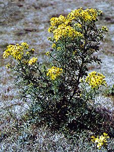
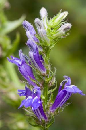
The range spans approximately 30 miles in length and 25 miles in width, with an average elevation of 9,000 feet and peaks exceeding 11,000 feet. The landscape is characterized by an eastern escarpment that drops significantly to the Rift floor, and many of its summits feature unique vegetation, such as groundsels and lobelias. Additionally, the area serves as a vital watershed, containing the headwaters of the Marun River near Kaibibich. The range extends northwestward as a broken chain reaching toward Mount Moroto in Uganda.1
How was the Great Rift Valley formed?
The Great Rift Valley, a primary component of the East African Rift System, has been forming for approximately 30 million years as the African and Arabian plates diverge.2
The formation process involves several geological mechanisms:
- Crustal Divergence: A rift valley typically forms when a block of the Earth’s crust drops down between two diverging lithospheric plates, similar to a keystone falling from an arch as its supports move apart.3
- Upwelling and Stretching: In the East African region, the process is often driven by the upwelling of hot material from the asthenosphere. This heat causes the overlying lithosphere to bulge upward, expand, and stretch, leading to the development of fractures and the eventual sinking of continental blocks.34
- Magmatism: As the crust thins and fractures, magma from the mantle rises to fill these gaps. This activity is frequently associated with extensive volcanism, which has helped shape the landscape and create massive features like Mount Kilimanjaro and Mount Kenya.234
What unique plants grow in high-altitude African mountains?
High-altitude African mountains, particularly those in East Africa, host a unique Afro-Alpine vegetation zone characterized by distinct altitudinal stratification and the phenomenon of giantism.67
Key plant life in these high-altitude regions includes:
- Giant Rosette Plants: A defining feature of these mountains is the presence of giant herbs that can reach heights of three meters or more. Notable examples include species of giant lobelia and tree groundsel (Dendrosenecio). These plants have evolved to survive freezing nightly temperatures by retaining dead leaf bases that insulate their water-containing stems.61
- Tussocky Grassland and Everlastings: Below the highest peaks, the ground is often covered in tussocky grasses and everlastings, which are composite plants known for retaining their color and form even after being dried.6
- Lady’s Mantle: Species of Alchemilla, or lady’s mantle, are commonly found across the Afro-Alpine zones of various East African mountains.6
- Mosses and Lichens: These hardy organisms can survive at extreme altitudes, reaching up to approximately 15,000 feet before giving way to bare rock and ice.6
This unique flora is largely composed of cold-loving plants that retreated to high elevations following post-Pleistocene temperature increases, leading to convergent evolution where similar traits emerged in unrelated species across different continents.61
Why are mountain forests important for water sources?
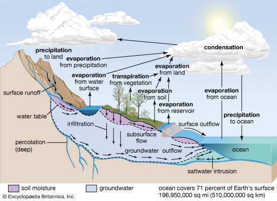
Mountain forests are essential for maintaining reliable water sources, particularly in steep terrain where their value often surpasses that of timber or recreation. They function as both filters and sponges, regulating the hydrologic cycle through several key mechanisms:9
- Water Regulation and Storage: Forest soils and litter layers act as sponges, absorbing precipitation and releasing it gradually. This ensures that streamflow remains uniform and reliable, preventing the rapid, destructive runoff characteristic of sparsely vegetated land.9
- Filtration and Quality: As water moves through the forest system, it is naturally filtered, resulting in high-quality water that is typically low in temperature and high in oxygen.9
- Erosion Control: By maintaining continuous cover, mountain forests stabilize soil and prevent the sedimentation that often degrades water quality. This protection is vital for downstream communities, which may depend entirely on the maintenance of forest cover on the foothills of peaks to secure their water supply.910
- Fog Interception: In specific regions, tree foliage captures water vapor from fog, which condenses and drips to the ground, providing a significant additional water yield.9
Sources
- Cherangany Hills — Encyclopædia Britannica
- East African Rift System — Encyclopædia Britannica
- tectonic basins and rift valleys - Rift valleys — Encyclopædia Britannica
- East African lakes - Geology, climate, and hydrology — Encyclopædia Britannica
- plate tectonics - Continental rifting — Encyclopædia Britannica
- East African mountains - Plant life — Encyclopædia Britannica
- Africa - Afromontane vegetation — Encyclopædia Britannica
- Mountain ecosystem - Flora — Encyclopædia Britannica
- forestry - Watershed management and erosion control — Encyclopædia Britannica
- Tree - The importance of trees — Encyclopædia Britannica
Published on · 3 min read