Chatham Strait
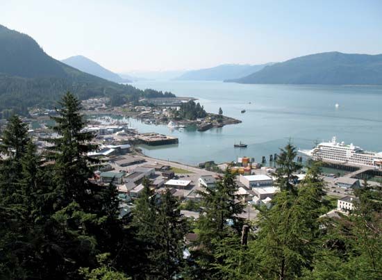
Chatham Strait is a narrow, deep, fault-formed passage located in the northern Alexander Archipelago of southeastern Alaska. Stretching 150 miles (240 km) in…
What is Chatham Strait?
Chatham Strait is a narrow, deep, fault-formed passage located in the northern Alexander Archipelago of southeastern Alaska. Stretching 150 miles (240 km) in length and ranging from 3 to 10 miles (5 to 16 km) in width, it serves as a vital navigable route within the Inside Passage1.1
The strait runs from the junction of Icy Strait and Lynn Canal southward to Coronation Island and the open sea. Geographically, it separates Chichagof and Baranof islands to the west from Admiralty and Kuiu islands to the east. The passage was named in 1794 by the British navigator George Vancouver in honor of Sir John Pitt, the 2nd Earl of Chatham.12
What is the Inside Passage?
The Inside Passage is a natural, sheltered sea route spanning more than 1,000 miles (1,600 km) from Seattle, Washington, to Skagway, Alaska.3
This route consists of a complex network of channels and straits situated between the mainland and a series of coastal islands, including Vancouver Island in British Columbia, Canada, and the Alexander Archipelago in Alaska. These landmasses provide essential protection from the turbulent storms of the Pacific Ocean, ensuring relatively smooth waters.3
Because the passage offers ample depth for vessels and numerous safe anchorages, it is the preferred route for coastal shipping to Alaska. Beyond its commercial utility, the passage is widely celebrated for its scenic beauty. Key towns located along this route include Victoria, Vancouver, and Prince Rupert in British Columbia, as well as Ketchikan, Wrangell, Petersburg, and Juneau in Alaska.3
How are fault-formed straits created?
Fault-formed straits, such as Chatham Strait, are created through the movement of the Earth’s crust along faults—fractures in rock where displacement has occurred.51
These features are often associated with normal faults, where the crust undergoes extension, causing a block of rock (the hanging wall) to slide downward relative to the block below (the footwall). When this process occurs on a large scale, it can create a graben, an elongate, depressed block of the crust bounded by steeply dipping normal faults.56
When these depressed blocks or rift valleys are located in coastal or marine environments, they can become submerged by the sea, forming deep, narrow channels or straits. The resulting topography is characterized by these lowered blocks, which provide the deep, navigable passages often found within larger archipelagos or coastal systems.561
What are the major islands of the Alexander Archipelago?
The Alexander Archipelago is a group of approximately 1,100 islands located off the coast of southeastern Alaska. These islands are essentially the peaks of a submerged section of the Coast Ranges.9
The major islands within the archipelago, listed from north to south, include:9
- Chichagof Island
- Admiralty Island
- Baranof Island (home to the city of Sitka)
- Kupreanof Island
- Kuiu Island
- Mitkof Island
- Wrangell Island
- Prince of Wales Island
- Revillagigedo Island (home to the city of Ketchikan)
These islands are largely contained within the Tongass National Forest and are historically significant as the ancestral home of the Tlingit and Haida peoples.9
Sources
- Chatham Strait — Encyclopædia Britannica
- Chatham Strait — Merriam-Webster
- Inside Passage — Encyclopædia Britannica
- Seattle - Early peoples and exploration — Encyclopædia Britannica
- normal fault — Encyclopædia Britannica
- horst and graben — Encyclopædia Britannica
- plate tectonics - Seafloor spreading — Encyclopædia Britannica
- plate tectonics - Back-arc basins — Encyclopædia Britannica
- Alexander Archipelago — Encyclopædia Britannica
- Alexander Archipelago — Merriam-Webster
Published on · 2 min read