Cunene River
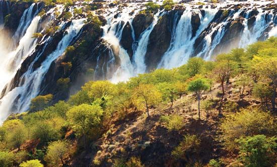
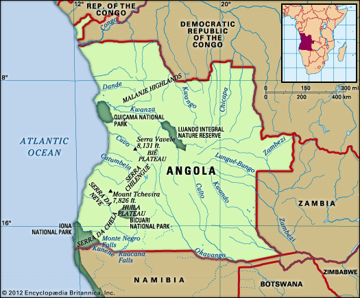
The Cunene River is located in southwestern Africa. It rises in the west-central highlands of Angola, northeast of Huambo.
Where is the Cunene River located, and what countries does it flow through?
The Cunene River is located in southwestern Africa. It rises in the west-central highlands of Angola, northeast of Huambo.1
The river flows through two countries:
- Angola: The river originates here and flows southward through the southwestern part of the country.12
- Namibia: After passing the Ruacana Falls, the river forms the international boundary between Angola and Namibia as it continues westward to the Atlantic Ocean.12
What are the major geographical features along the course of the Cunene River?
The Cunene River features a diverse landscape as it travels 587 miles from the Angolan highlands to the Atlantic Ocean. Key geographical features include:
- Granite Uplands and Plains: The river begins in the west-central highlands of Angola and flows through a steep granite bed before reaching the Kalahari Desert, where it floods the sands during the wet season.1
- Waterfalls and Rapids: Notable drops include the Ruacana Falls, which plunge 230 feet, and the Epupa (Montenegro) Falls, which exceed 100 feet in height.1
- Gorge Tract: After the Ruacana Falls, the river enters a dramatic gorge between the Zebra and Baynes mountains. The riverbed here lies approximately 4,000 feet below the mountain peaks.1
- Desert and Coastal Features: The river exits the gorge into the Namib Desert. Its mouth is lagoonlike and is frequently blocked by a sandbar during the dry season.1
Human-made structures, such as the Matala Dam and the Ruacana hydroelectric project, also significantly alter the river’s flow for irrigation and power generation.12
What is the significance of the Cunene River for the local ecosystems and wildlife?
The Cunene River serves as a vital lifeline for the arid regions it traverses, particularly because it is one of the few rivers in the Namib Desert that flows permanently on the surface.1
Its significance for local ecosystems and wildlife includes:
- Reliable Water Source: In an environment characterized by minimal rainfall and fragmentary drainage, the Cunene provides a consistent water supply where other streams are often seasonal or terminate in salt pans.1
- Seasonal Wetland Support: During the wet season, the river floods the sands of the northern Kalahari Desert, creating temporary habitats that support local flora and fauna.4
- Coastal Estuary: The river’s lagoonlike mouth at the Atlantic Ocean provides a unique interface between freshwater and marine environments, which is essential for various aquatic species, despite being periodically closed by a sandbar during the dry season.4
While the river is essential for biodiversity, its flow is also heavily managed for human needs, including irrigation and hydroelectric power at sites like the Ruacana dam.4
Are there any notable dams or hydroelectric projects on the Cunene River?
The Cunene River is a critical site for hydroelectric development and water management in southwestern Africa. Several major projects have been constructed to harness its power and support regional agriculture:
- Matala Dam: Located in Angola, this dam raises the river level by 26 feet, creating a head of approximately 68 feet used for hydroelectric generation.3
- Calueque Dam: Completed in 1976 and situated 25 miles upriver from the Ruacana Falls, this dam is designed to facilitate irrigation for southern Angola and the Owambo region of northern Namibia.1
- Ruacana Dam and Power Station: Situated at the border between Angola and Namibia, this site includes a diversion dam located directly above the Ruacana Falls. It serves as a primary source of electricity for most of Namibia and provides essential irrigation water for the surrounding regions.13
These projects have historically been subject to complex political and regional tensions, particularly during the late 20th century, but they remain central to the infrastructure of both Angola and Namibia.1
Sources
- Cunene River — Encyclopædia Britannica
- Angola - Drainage — Encyclopædia Britannica
- Ruacana — Encyclopædia Britannica
- Namib - Drainage — Encyclopædia Britannica
Published on · 3 min read