Dîmbovița River
The Dâmbovița River is a river located in south-central Romania. It originates in the Transylvanian Alps and flows for approximately 155 miles (250 km)…
What is Dîmbovița River?
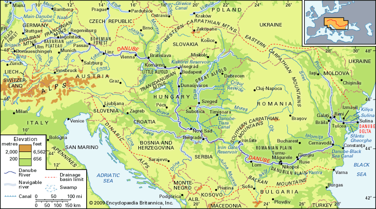
The Dâmbovița River is a river located in south-central Romania. It originates in the Transylvanian Alps and flows for approximately 155 miles (250 km) before emptying into the Argeș River.12
Notably, the river flows through Bucharest, the capital of Romania, on a course that runs parallel to the Argeș. The name Dâmbovița also refers to a county in southern Romania, which is drained by the Dâmbovița, Ialomița, and Argeș rivers.23
How does the Dâmbovița River influence the development of Bucharest?
The Dâmbovița River serves as the geographic foundation for Bucharest, the capital of Romania. Located in the middle of the Romanian plain, the city was established and grew along the banks of this northern tributary of the Danube.
Historically, the river provided the essential setting for the city’s emergence as a center of power. By the 15th century, Vlad III (the Impaler) utilized the strategic location of the settlement to construct a fortress intended to defend the Walachian state against external threats. As the city evolved into the economic and administrative hub of the region, the river remained a central feature of its urban landscape.
While the Dâmbovița is a relatively small river, its presence has been integral to the city’s identity for centuries, anchoring the development of the municipality from its early days as a fortified site to its modern status as a major European capital.
What are the main geographical features of the Transylvanian Alps?
The Transylvanian Alps, also known as the Southern Carpathians, are a mountainous region in south-central Romania that stretch approximately 155 miles (250 km) from the Prahova River valley in the east to the gap formed by the Timiș and Cerna rivers.6
Key geographical features include:
- Elevation and Relief: The region has an average elevation of 4,920–5,740 feet (1,500–1,750 meters). It is characterized by a higher, more continuous, and more impassable terrain than other Carpathian segments, featuring Alpine-type relief forms6.67
- Highest Peaks: The range contains the highest point in Romania, Mount Moldoveanu (8,346 feet/2,544 meters), located in the Făgăraș Mountains.67
- Geologic Composition: Unlike the Eastern Carpathians, which contain significant volcanic and flysch bands, the Transylvanian Alps consist primarily of metamorphic rocks.7
- Structure: The region is divided into three groups of ranges and is broken by only four passes. It also features one major intermontane depression, the Petroșani.6
What role do rivers play in the history of Romania?
Rivers have been fundamental to the history and development of Romania, serving as vital arteries for transportation, economic activity, and political identity.
Strategic and Political Significance
The Danube River has long acted as a major geographic and political boundary, shaping the nation’s frontiers and facilitating international commerce. Historically, rivers like the Prut and Dniester defined the borders of the historic principality of Moldavia, which eventually united with Walachia to form the modern Romanian state. These waterways were often sites of contention between regional powers, including the Ottoman Empire and Russia, influencing territorial shifts such as the loss and recovery of Bessarabia.4910
Economic and Urban Development
- Agriculture: Romanian rivers have historically supported the country’s agricultural backbone. The Danube floodplain and the Danube delta have been essential for fishing and, through extensive diking and drainage projects, for expanding grain production.1112
- Urban Centers: Major cities, including the capital, Bucharest, developed along riverbanks like the Dâmbovița, which provided the necessary setting for early settlements and administrative growth.13
- Energy and Industry: Since the 1940s, rivers have been harnessed for their hydroelectric potential, most notably at the Iron Gate on the Danube, a joint project that significantly improved navigation and power generation.412
Sources
- Dîmbovița River — Encyclopædia Britannica
- Dâmbovița — Encyclopædia Britannica
- Argeş River — Encyclopædia Britannica
- Romania - Drainage of Romania — Encyclopædia Britannica
- Bucharest — Encyclopædia Britannica
- Transylvanian Alps — Encyclopædia Britannica
- Carpathian Mountains - Physiography of the Carpathian Mountains — Encyclopædia Britannica
- Romania - Land of Romania — Encyclopædia Britannica
- Romania - Agriculture, forestry, and fishing — Encyclopædia Britannica
- Prut River — Encyclopædia Britannica
- Romania - Transportation and telecommunications — Encyclopædia Britannica
- Moldova - History of Moldova — Encyclopædia Britannica
- Romania - Relief — Encyclopædia Britannica
- Moldavia — Encyclopædia Britannica
Published on · 3 min read