Folda
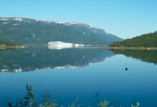
Folda is a fjord located in northern Norway. Situated approximately 75 miles north of the Arctic Circle, its mouth opens into the Vest Fjord of the Norwegian…
What is Folda?
Folda is a fjord located in northern Norway. Situated approximately 75 miles north of the Arctic Circle, its mouth opens into the Vest Fjord of the Norwegian Sea.1
The fjord extends inland through two primary branches:
These branches are characterized by small fishing villages where herring serves as the primary catch. Additionally, the heads of both branches are traversed by the North Cape Highway, which provides a vital transportation link between northern coastal counties and the southern, more densely populated regions of the country.1
Please note that “Folda” is a specific geographical location; it should not be confused with the term “foldable,” which refers to objects—such as certain electronic devices—designed to be folded for storage.2
How are fjords formed by glaciers?
Fjords are long, narrow arms of the sea formed through the marine inundation of glaciated valleys. Their creation is primarily attributed to the immense erosive power of thick glaciers that carved deep, U-shaped valleys into the landscape.345
These glaciers were often heavy enough to erode valley bottoms far below sea level before the ice began to float. As the glaciers moved, they were most active and vigorous near their source, which explains why many fjords are deeper in their middle and upper reaches than at their seaward ends. Following the retreat or melting of the ice, the rising ocean waters flooded these deep troughs, creating the modern fjord.36
While the glacial origin theory is widely accepted, some scientists suggest that tectonic activity may have also played a role, with glaciers serving to modify pre-existing large valleys. Today, these features are characterized by steep, vertical walls and shallow rock thresholds at their mouths.53
What is life like in a Norwegian fishing village?
Life in a Norwegian fishing village is deeply connected to the country’s rugged coastal environment and a long-standing maritime heritage. Historically, these settlements have served as the backbone of the coastal economy, where fishing plays a role equivalent to forestry in inland regions.7
Key aspects of life in these communities include:
- Economic Livelihood: Fishing remains a primary occupation, often supported by a large fish-processing industry. Many residents balance seasonal fishing with other work, such as farming or forestry, to supplement their income. While the number of registered fishing vessels has declined over the decades, the industry remains vital, with many boats still owned by the fishermen themselves.7
- Settlement Patterns: Unlike many other parts of Europe, Norway has historically lacked traditional agricultural villages. Instead, coastal populations are often distributed among hundreds of small villages nestled along the fjords, islands, and rugged coastlines.89
- Cultural Traditions: Daily life is enriched by strong traditions, including storytelling, folklore, and the wearing of the bunad (national costume) on festive occasions. The local diet is heavily influenced by the sea, featuring staples like salmon, cod, and various processed seafood products.107
- Transportation: Because of the challenging terrain, coastal ferries and ships serve as essential links for intercity travel, connecting these remote villages to larger trading centers and cities.8
What are the main characteristics of the Arctic Circle?
The Arctic Circle is a mathematical line of latitude located at approximately 66°30′ N. Because of Earth’s axial tilt of about 23 1/2° to the vertical, this parallel serves as the southern boundary of the region where the sun does not set for at least one full day each year (around June 21) or does not rise for at least one day (around December 21).1314
While the Arctic Circle is defined by this specific latitude, it is often considered less useful as a geographic boundary than the tree line, which better reflects the actual nature of the terrain and climate. Key characteristics of the region within and near the Arctic Circle include:14
- Extreme Seasonal Variation: The region experiences dramatic shifts in daylight, ranging from the “midnight sun” in summer to long periods of darkness in winter.1315
- Climate: The area is defined by extreme temperature fluctuations, permafrost, and the presence of permanent snow and ice in higher elevations.1416
- Ecosystems: Arctic ecosystems are characterized by relatively low species diversity and simplicity, with plant and animal life highly adapted to short growing seasons and harsh winter conditions.1718
- Environmental Sensitivity: The region is increasingly recognized as a bellwether for global climatic change, as it has been warming at a rate significantly faster than the rest of the world.14
Sources
- Folda — Encyclopædia Britannica
- foldable — Merriam-Webster
- fjord — Encyclopædia Britannica
- glacial landform - Erosional landforms of continental glaciers — Encyclopædia Britannica
- list of fjords — Encyclopædia Britannica
- estuary - Geology and geomorphology — Encyclopædia Britannica
- Norway - Agriculture, forestry, and fishing — Encyclopædia Britannica
- Norway - Daily life and social customs — Encyclopædia Britannica
- North Sea - Fisheries — Encyclopædia Britannica
- Norway - History — Encyclopædia Britannica
- Vestlandet — Encyclopædia Britannica
- Norway - Settlement patterns — Encyclopædia Britannica
- Arctic Circle — Encyclopædia Britannica
- Polar ecosystem - Development and structure of populations and communities — Encyclopædia Britannica
- Arctic — Encyclopædia Britannica
- Arctic - Climate of the Arctic — Encyclopædia Britannica
- Native American - The Arctic — Encyclopædia Britannica
- Arctic - The people of the Arctic — Encyclopædia Britannica
Published on · 3 min read