Forestier Peninsula
The Forestier Peninsula is a peninsula located in southeastern Tasmania, Australia. It measures approximately 12 by 9 miles (19 by 14 km) and is bounded by…
What is Forestier Peninsula?
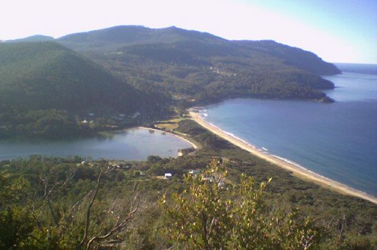
The Forestier Peninsula is a peninsula located in southeastern Tasmania, Australia. It measures approximately 12 by 9 miles (19 by 14 km) and is bounded by the Tasman Sea to the east and Norfolk Bay to the west.1
The peninsula is connected to the Tasmanian mainland by a short isthmus to the north and to the Tasman Peninsula to the south via Eaglehawk Neck, a narrow strip of land only 1/4-mile wide. Historically, this neck served as a critical barrier for the Port Arthur penal colony; guards used chained dogs across the isthmus to prevent prisoners from escaping. Today, the area is also known for its “tessellated pavement,” a unique geological formation that was designated a State Reserve in 1966.1
What is the history of the Port Arthur penal colony?
Established in 1830 by George Arthur, the Port Arthur penal colony served as the primary destination for transported convicts who had committed further offenses while in the colony of Van Diemen’s Land (modern-day Tasmania).23
Located on the Tasman Peninsula, the site was chosen for its isolation. The only land access was via Eaglehawk Neck, a narrow isthmus guarded by chained dogs to prevent escapes. Between 1835 and 1849, the complex also operated a model reformatory for boys at Point Puer.12
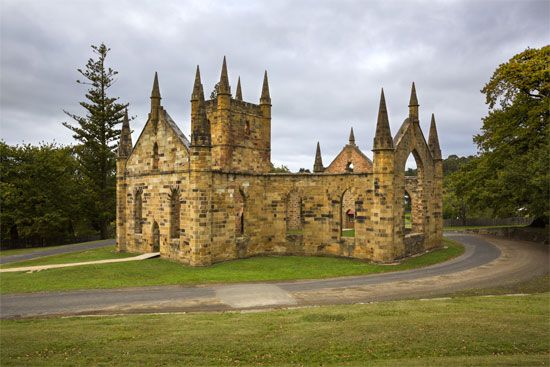
Although the transportation of convicts to the region officially ended in 1853, the facility remained in operation for another 24 years. Throughout its history, between 12,000 and 14,000 prisoners passed through the site. Today, the ruins—including a convict-built church and the “Isle of the Dead”—are preserved as a significant historical site and tourist attraction.2
How is a tessellated pavement formed?
The term “tessellated pavement” refers to two distinct concepts: a man-made architectural feature and a natural geological formation.
Architectural Tessellated Pavement
In art and architecture, a tessellated pavement is a floor covering constructed from small, regular shapes known as tesserae. These pieces—typically stone, glass, or ceramic—are fitted together into intricate geometric or pictorial designs and secured with mortar or grout. This technique gained widespread popularity during the Hellenistic Age and became a hallmark of Roman interior design for baths and public buildings.4
Geological Tessellated Pavement
In a natural context, such as the famous formation on the Forestier Peninsula, the term describes a rock surface that appears to be tiled. While the provided search results do not detail the specific formation process of the Tasmanian site, similar natural “pavement” structures, such as pavement karst, are created through weathering. These features often develop when bare bedrock is exposed—frequently by glacial activity—and subsequently shaped by differential solution from rainfall and meltwater, which widens joints and fractures in the stone.15
What are some other unique landforms found in Tasmania?
Tasmania features a diverse array of unique landforms shaped by its complex geological history and climate. Beyond its well-known coastal features, the island is defined by several distinct geographical structures:
- Glaciated Central Plateau: This dominant feature is a lake-studded highland area bounded by a 2,000-foot (610-metre) fault scarp. It slopes gently toward the southeast and serves as a primary example of glaciated terrain in the region.6
- Great Western Tiers: These basaltic mountains form the northern and eastern borders of the Central Plateau. They are characterized by dramatic fault-formed scarps that rise to 4,000 feet (1,200 m) in some areas.7
- Drowned Coastline: In the southeast, postglacial submergence has created one of the world’s finest examples of a drowned coastline, where rising sea levels have flooded river valleys and coastal depressions.6
- Coastal Erosion Features: The Tasman Peninsula is heavily embayed and eroded, featuring vertical sea cliffs, isolated rock stacks, and blowholes that create water fountains when waves rush into them.8
- Rugged Highland Ranges: The southwest is marked by parallel highland ranges separated by wide valleys, forming part of the expansive Tasmanian Wilderness World Heritage site.910
Sources
- Forestier Peninsula — Encyclopædia Britannica
- Port Arthur — Encyclopædia Britannica
- Tasmania - Prehistory and European exploration — Encyclopædia Britannica
- tessellated pavement — Encyclopædia Britannica
- cave - Pavement karst — Encyclopædia Britannica
- Tasmania - Relief — Encyclopædia Britannica
- Tasman Peninsula — Encyclopædia Britannica
- Tasman Geosyncline — Encyclopædia Britannica
- Great Western Tiers — Encyclopædia Britannica
- Southwest National Park — Encyclopædia Britannica
- Franklin-Gordon Wild Rivers National Park — Encyclopædia Britannica
- cave - Doline karst — Encyclopædia Britannica
Published on · 3 min read