Great Western Tiers
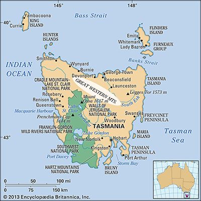
The Great Western Tiers are a range of mountains located in central Tasmania, Australia. These mountains serve as the northern and eastern boundary of the…
What is Great Western Tiers?
The Great Western Tiers are a range of mountains located in central Tasmania, Australia. These mountains serve as the northern and eastern boundary of the island’s Central Plateau.1
Geologically, the Tiers are basaltic in composition and feature fault-formed scarps that reach elevations of 4,000 feet (1,200 m) near the River Mersey. The highest point in the range is Mount Ironstone, which stands at 4,736 feet (1,444 m). From this peak, the terrain slopes gradually toward the south, while the eastern face provides a dramatic overlook of the Macquarie River valley.1
The region is significant for its role in renewable energy, as the steep drops created by streams flowing over the mountain edges are utilized for the Great Lake–South Esk and the Mersey–Forth hydroelectric projects. Additionally, the gentle slopes found at the base of the mountains support productive farmland.1
How are hydroelectric projects powered by mountain streams?
Hydroelectric projects in mountainous regions harness the potential energy of water by utilizing the elevation difference between a high-altitude source and a lower-elevation powerhouse, a distance known as the head.3
The process generally functions as follows:
- Collection: Dams are constructed to impound rivers or streams, creating a reservoir that stores water at a higher elevation.23
- Conveyance: The stored water is directed downward through large pipes or tunnels called penstocks.2
- Energy Conversion: As the water reaches the bottom of the penstocks, its pressure and flow cause turbines to rotate. These turbines are connected to generators, which convert the mechanical energy of the spinning turbines into electricity.2
- Transmission: Transformers then increase the voltage of the generated electricity to make it suitable for long-distance transmission to power grids.2
Because the power potential is directly proportional to the head, mountainous areas are highly effective for these installations, often requiring smaller volumes of water than low-head sites to produce equivalent amounts of power.2
What makes the Central Plateau of Tasmania unique?
The Central Plateau of Tasmania is a defining geographical feature of the island, distinguished by its unique glaciated, lake-studded landscape. Bounded on its northern and eastern edges by a 2,000-foot (610-metre) fault scarp, the plateau slopes gently toward the southeast, ranging in elevation from 3,500 to 2,000 feet (1,070 to 610 metres).6
Several factors contribute to its significance:
- Ecological Diversity: The region is part of the broader Tasmanian Wilderness, a World Heritage site known for its alpine vegetation and cool temperate flora, including endemic species like cushion plants and various mountain-adapted shrubs.78
- Recreational Value: The plateau is world-renowned for its extensive network of lakes, which constitute one of the finest trout fisheries globally.1
- Geological Character: It serves as a high-altitude interior region that contrasts sharply with the island’s western ridges and eastern lowlands. Its borders are defined by the Great Western Tiers, a mountain range that provides a dramatic transition from the plateau to the surrounding valleys.69
How do fault-formed scarps change a landscape?
Fault-formed scarps significantly alter landscapes by creating abrupt changes in elevation and influencing the development of drainage networks. These features are generally categorized into two types:
- Fault Scarps: These are cliffs or escarpments created directly by the vertical displacement of rock along a fault during tectonic activity. They often mark the boundaries of block-fault mountains or the edges of rift valleys, where one side of the crust has dropped significantly relative to the other.111213
- Fault-line Scarps: These features form through the process of erosion. They occur when differential erosion wears away softer rock that has been brought into contact with more resistant rock due to previous faulting, eventually exposing a cliff face.14
Beyond their physical presence, these scarps dictate the behavior of local rivers. Stream networks often adjust to these structural changes; for instance, drainage lines may become aligned with faults, or streams may be forced to cut across new structures, sometimes maintaining their original courses as “antecedent” streams. In areas where faults intersect at right angles, they can produce distinct rectangular drainage patterns.1516
Sources
- Great Western Tiers — Encyclopædia Britannica
- Did you know? — Merriam-Webster
- hydroelectric power — Encyclopædia Britannica
- reservoir — Encyclopædia Britannica
- dam - Rise of environmental and economic concerns — Encyclopædia Britannica
- Tasmania - Relief — Encyclopædia Britannica
- Tasmanian Wilderness — Encyclopædia Britannica
- Tasmania - Sports and recreation — Encyclopædia Britannica
- Tasmania - Plant and animal life — Encyclopædia Britannica
- Franklin-Gordon Wild Rivers National Park — Encyclopædia Britannica
- fault-line scarp — Merriam-Webster
- mountain - Geomorphic characteristics — Encyclopædia Britannica
- mountain - Alpine- (or Himalayan-)type belts — Encyclopædia Britannica
- fault scarp — Merriam-Webster
- river - Drainage patterns — Encyclopædia Britannica
- valley - Drainage patterns — Encyclopædia Britannica
- fault — Encyclopædia Britannica
Published on · 3 min read