Great Rye Island
Great Rye Island (known in Slovak as Žitný ostrov) is a riverine island located in the Západné Slovensko region of Slovakia. Situated southeast of…
What is Great Rye Island?
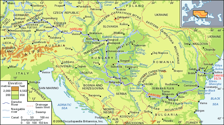
Great Rye Island (known in Slovak as Žitný ostrov) is a riverine island located in the Západné Slovensko region of Slovakia. Situated southeast of Bratislava, the island is bounded by the Danube to the south and the Little Danube and Váh rivers to the north.1
The island is formed by rich alluvial sediments deposited by the Danube within the Little Alföld, a plain shared between Slovakia and Hungary. Due to its fertile soil, the land is extensively cultivated for grain production, particularly wheat and rye. To support this agricultural activity, the eastern portion of the island, located northwest of Komárno, has been canalized. It is geographically similar to the Little Schütt Island (Szigetköz) located on the Hungarian side of the river.1
What is the Little Alföld plain?
The Little Alföld (also known as the Little Hungarian Plain or Kisalföld) is an extensive basin covering approximately 3,000 square miles (8,000 square km) in northwestern Hungary, extending into Austria and Slovakia, where it is referred to as the Podunajská Lowland.3
Geographically, the basin is bounded by the Danube River to the north, the foothills of the Austrian Alps to the west, and the highlands of Transdanubia—specifically the Bakony Mountains and Vértes—to the south and east. While its central and northern sections are true plains, the margins consist of low hills and alluvial fans.34
The region is an exceptionally fertile agricultural hub, producing wheat, corn, rye, barley, and various vegetables, alongside significant livestock breeding. The basin is drained primarily by the Danube and its tributaries, such as the Váh River and the Rába River.3 It is separated from the larger Great Alföld by a mountain system that forms the backbone of Hungary.34
How do rivers create alluvial sediments?
Rivers create alluvial sediments through the physical interaction of flowing water and the natural channels they traverse, a process known as fluvial process. As rivers transport rock detritus from higher to lower elevations, they act as agents of both erosion and deposition.56
The creation of these sediments involves several key mechanisms:
- Erosion and Transport: Rivers derive sediment from the disintegration of surface layers on hills and valley slopes, as well as from the erosion of the riverbed itself. The river’s ability to transport this material depends on its velocity, which is influenced by channel slope and roughness. Faster currents near a river’s source can carry large boulders, which are gradually ground down into smaller particles like gravel, sand, and silt as they move downstream.5
- Deposition: When a river’s transporting energy decreases—often due to a reduction in velocity—it can no longer carry its sediment load, leading to deposition. This occurs in various environments, such as:6
- Floodplains: During floods, rivers overflow their banks and deposit sediment across the valley surface. This includes vertical accretion (overbank deposition) and lateral accretion, where sediment is deposited on the inside of meander bends to form point bars.7
- Alluvial Fans: These are fan-shaped deposits that accumulate at the mouth of a mountain canyon when a stream’s sediment-carrying capacity suddenly diminishes as it exits into a flatter basin.8
- Deltas: When a river reaches a body of standing water, it may deposit its remaining sediment load to form a delta, with the specific shape and composition determined by the balance between fluvial action and marine energy.9
What are the Cinque Ports in England?
The Cinque Ports were a medieval confederation of ports in southeastern England established to provide ships and men for the king’s service. Originally consisting of five ports—Hastings, New Romney, Hythe, Dover, and Sandwich—the group later expanded to include the “ancient towns” of Winchelsea and Rye, along with over 30 other associated towns in Kent and Sussex.1314
Likely organized during the reign of Edward the Confessor, the ports gained significant privileges after the Norman Conquest in exchange for their naval contributions. They served as the nucleus of the royal fleet until the 14th century, after which their monopoly declined due to coastal changes and silting. Today, only Dover remains a major port, and the confederation’s historical jurisdiction has been largely abolished, save for Admiralty matters. The highest official is the lord warden, who resides at Walmer Castle.13
Sources
- Great Rye Island — Encyclopædia Britannica
- Rye — Encyclopædia Britannica
- Little Alfold — Encyclopædia Britannica
- Hungary - Relief — Encyclopædia Britannica
- river - Environments of deposition — Encyclopædia Britannica
- fluvial process — Encyclopædia Britannica
- river - Floodplain deposits, origins, and features — Encyclopædia Britannica
- river - Time and the floodplain system — Encyclopædia Britannica
- river - Peak discharge and flooding — Encyclopædia Britannica
- alluvial fan — Encyclopædia Britannica
- river - Rivers as agents of landscape evolution — Encyclopædia Britannica
- river - Classification of deltas — Encyclopædia Britannica
- Cinque Ports — Encyclopædia Britannica
- Cinque Ports — Merriam-Webster
Published on · 3 min read